| Pojuca River | |
|---|---|
 | |
| Location | |
| Country | Brazil |
| Physical characteristics | |
| Source | |
| • location | Bahia state |
The Pojuca River is a river of Bahia state in eastern Brazil.
| Pojuca River | |
|---|---|
| | |
| Location | |
| Country | Brazil |
| Physical characteristics | |
| Source | |
| • location | Bahia state |
The Pojuca River is a river of Bahia state in eastern Brazil.

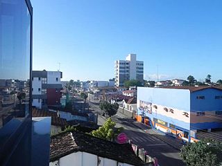
Feira de Santana is a city in Bahia, Brazil. It is the second-most populous city in the state, with a population of 619,609 according to IBGE's estimate in 2020. It is located 100 km northwest of Salvador, Bahia's capital city. These cities are connected by BR-324, a four-lane divided highway.
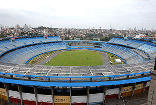
The Estádio Fonte Nova, also known as Estádio Octávio Mangabeira, was a football stadium inaugurated on January 28, 1951 in Salvador, Bahia, with a maximum capacity of 66,080 people. The stadium was owned by the Bahia government, and was the home stadium of Esporte Clube Bahia and Esporte Clube Vitória. Its formal name honors Octávio Cavalcanti Mangabeira (1886–1960), a civil engineer, journalist, and former Bahia state governor from 1947 to 1954.
Cedar City is a former incorporated city in southern Callaway County, Missouri, United States. It is located on the Missouri River floodplain across the river channel from Jefferson City and is near the interchange of U.S. Routes 54 and 63. It is part of the Jefferson City, Missouri Metropolitan Statistical Area.

Camaçari is a city in Bahia, Brazil. It is located at 12°41′51″S38°19′27″W. It is part of the Salvador Metropolitan Region, being the industrial city of the metropolis. Camaçari covers 784.658 km2 (302.958 sq mi), and had an estimated population of 304,302 in 2020, with a population density of 310 per square kilometer. The municipality consists of three districts: Camaçari, Abrantes, and Monte Gordo.
Alagoinhas is a city in the Brazilian state of Bahia. It is located at around 12°8′9″S38°25′8″W. It was founded in 1852. In 1974, the city was made the seat of the Roman Catholic Diocese of Alagoinhas.

Lauro de Freitas is a municipality in Bahia, Brazil. It covers 57.66 km2 (22.26 sq mi) and a population of 201,635. Lauro de Freitas has a population density of 3,376 inhabitants per square kilometer. It is located 15 km (9.3 mi) from the state capital of Bahia, Salvador.

Estádio Governador Roberto Santos, usually known as Estádio de Pituaçu, is a football stadium located in Salvador, Bahia state, Brazil. The stadium is owned by the Government of Bahia state and it was built in 1979. Its formal name honors Roberto Santos, who was a federal deputy, the governor of Bahia state from 1975 to 1979, a professor at the Universidade Federal da Bahia's Faculty of Medicine, and was the Minister of Health during José Sarney's government. The stadium became one of the most important stadiums in Bahia after the Fonte Nova stadium's demolition was announced, and it has a maximum capacity of 32,157 people, but it will be expanded to a maximum capacity of 34,000 people. It is Esporte Clube Bahia's home stadium during the building of the Arena Fonte Nova.

Derby is an unincorporated community along the Ohio River in far southern Union Township, Perry County, in the U.S. state of Indiana. It lies at the intersection of State Roads 66 and 70 above the city of Tell City, the county seat of Perry County. Its elevation is 453 feet (138 m), and it is located at 38°1′49″N86°31′38″W. Although Derby is unincorporated, it has a post office, with the ZIP code of 47525.

Candeias is a municipality in Brazil, in the state of Bahia. It is located 46 kilometres (29 mi) to the north of Salvador, the capital of Bahia. The town is near the BR-324 motorway. The town has a current population of 87,458.
The Juazeiro River is a river of Bahia state in eastern Brazil.
Terra Nova (Bahia) is a municipality in the state of Bahia in the North-East region of Brazil. It is located at a latitude 12 ° 23'30 "South and longitude 38 ° 37'30 "west. It has a population of 13,025 (2020 estimate).

Madre de Deus is a municipality in the state of Bahia in the North-East region of Brazil. The municipality is located on a small archipelago in the Bay of All Saints; it both the smallest municipality by land mass in Bahia and the Northeastern region of Brazil. Madre de Deus is spread across two islands, the Ilha de Madre de Deus and the much smaller Ilha de Maria Guarda. It sits in close proximity to two others islands, the Ilha do Bom Jesus dos Passos and Ilha dos Frades, both part of the city of Salvador. The Ilha de Madre de Deus is further subdivided into the neighborhoods of Centro, Suape, Cação, Marezinha, Mirim, Alto do Paraíso, Apicum, Nova Madre de Deus e Quitéria, Alto da Matriz, Alto do Santo Antônio, Alto da Boa Vista, Cururupeba, Malvinas, and Nova Brasília.

Simões Filho is a municipality in the state of Bahia in the North-East region of Brazil.

Jaguaripe is a municipality in the state of Bahia in the North-East region of Brazil. It covers 863.424 km2 (333.370 sq mi), and has a population of 18,981 with a population density of 18.32 inhabitants per square kilometer. Jaguaripe is located 130 km (81 mi) from the state capital of Bahia, Salvador. Jaguaripe shares a border with the municipalities of Aratuípe, Nazaré, Maragogipe, Laje, São Miguel das Matas, and Santo Antônio de Jesus. It was the first municipality created outside of Salvador, dating to 1693.

Saubara is a municipality in the state of Bahia in the North-East region of Brazil.
Aramari, Bahia is a municipality in the state of Bahia in the North-East region of Brazil.

The Bahia incident was a naval skirmish fought in late 1864 during the American Civil War. A Confederate navy warship was captured by a Union warship in the Port of Salvador, Bahia, Brazil. The engagement resulted in a United States victory, but also sparked an incident between the United States and Brazil, over the American violation of Brazil's neutrality by illegally attacking a vessel in a Brazilian harbor.

Chapada Diamantina is a region of Bahia state, in the Northeast of Brazil. This mountain range is known as “Serra do Espinhaço,” in Minas Gerais state, south of Bahia.

The Instituto Federal de Educação, Ciência e Tecnologia da Bahia (IFBA) is an institution that offers high and professional educations by having a pluricurricular form. It is a multicampi institution, especialized in offering professional and technological education in different areas of knowledge.

Bahia State University is a public university in the Brazilian state of Bahia.
Coordinates: 12°35′50″S38°01′49″W / 12.59722°S 38.03028°W