Related Research Articles
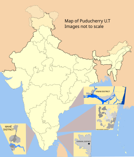
Karaikal district is one of the four districts of the Union Territory of Puducherry in India.

Sobiejuchy is a village in the administrative district of Gmina Żnin, within Żnin County, Kuyavian-Pomeranian Voivodeship, in north-central Poland. It lies approximately 6 kilometres (4 mi) north of Żnin and 31 km (19 mi) south-west of Bydgoszcz.
Falęcice-Parcela is a village in the administrative district of Gmina Promna, within Białobrzegi County, Masovian Voivodeship, in east-central Poland. It lies approximately 6 kilometres (4 mi) north-west of Promna, 9 km (6 mi) north-west of Białobrzegi, and 56 km (35 mi) south of Warsaw.
Żebry-Włosty is a village in the administrative district of Gmina Gzy, within Pułtusk County, Masovian Voivodeship, in east-central Poland. It lies approximately 13 kilometres (8 mi) west of Pułtusk and 56 km (35 mi) north of Warsaw.
Ługi Ujskie is a village in the administrative district of Gmina Ujście, within Piła County, Greater Poland Voivodeship, in west-central Poland. It lies approximately 4 kilometres (2 mi) north of Ujście, 6 km (4 mi) south of Piła, and 79 km (49 mi) north of the regional capital Poznań.
Kotary is a village in the administrative district of Gmina Panki, within Kłobuck County, Silesian Voivodeship, in southern Poland. It lies approximately 4 kilometres (2 mi) north-west of Panki, 16 km (10 mi) west of Kłobuck, and 75 km (47 mi) north of the regional capital Katowice.
Radówek is a village in the administrative district of Gmina Górzyca, within Słubice County, Lubusz Voivodeship, in western Poland, close to the German border. It lies approximately 7 kilometres (4 mi) south-east of Górzyca, 16 km (10 mi) north-east of Słubice, 48 km (30 mi) south-west of Gorzów Wielkopolski, and 79 km (49 mi) north-west of Zielona Góra.
ONGC Public School is located at Neravy in the Karaikal district of Puducherry union territory in India. It has classes from lower Kindergarten to 12. Good Shepherd, Kaveri & ONGC are the 3 schools under CBSE school which have up to 12th standard in Karaikal.
Tirumalarajanar River is a tributary of the Kodamurutti River which, itself, is a tributary of the river Kaveri. It branches off from the Kodamurutti near Papanasam and flows through the districts of Thanjavur, Tiruvarur and Nagapattinam in Tamil Nadu and the Niravi and Tirumalarajanpattinam communes of the Karaikal District of Puducherry before joining the Bay of Bengal near Tirumalarajanpattinam.

Tirumalarajanpattinam is a census town and commune in the Karaikal District of Puducherry, India. Tirumalarajanpattinam is situated at a distance of 6 kilometres to the south of Karaikal municipality.

Keezhaiyur is a revenue village in the Karaikal taluk of Karaikal District. It is situated at a distance of about 6 kilometres south-east of Karaikal town and 2 kilometres east of Tirumalarajanpattinam commune.
Varichikudy is a revenue village in the Karaikal taluk of Karaikal District in the union territory of Puducherry in India. It is situated at a distance of about 6 kilometres north of Karaikal town.
Agarakurumbagaram is a revenue village in the Thirunallar taluk of Karaikal District. It is situated to the north-west of Karaikal town.
Sellur is a revenue village in the Thirunallar taluk of Karaikal District. It is situated to the west of Thirunallar.
Vettar is a river flowing in Tiruvarur district, Thanjavur district and Nagapattinam district of the Indian state of Tamil Nadu.
The Peralam–Karaikal line is a branch line connects Peralam, Tamil Nadu with Karaikal, Puducherry in South India.
Arundavapuram is a large village located in Ammapettai block, Papanasam Taluk, Thanjavur District, India.

Peralam Junction railway station is a railway junction station serving the village of Peralam in Tamil Nadu, India.
Patchur, Karaikal is a small revenue village (hamlet) in Karaikal taluk, Karaikal district, Puducherry, India. This area is mostly famous for the Sri Dharmasasta Ayyapan Temple. This is the only Ayyapan temple in the Karaikal region.
References
- "Karaikal District - Revenue Administration". Karaikal District. Archived from the original on 2012-03-08.
Coordinates: 10°54′N79°43′E / 10.900°N 79.717°E

A geographic coordinate system is a coordinate system that enables every location on Earth to be specified by a set of numbers, letters or symbols. The coordinates are often chosen such that one of the numbers represents a vertical position and two or three of the numbers represent a horizontal position; alternatively, a geographic position may be expressed in a combined three-dimensional Cartesian vector. A common choice of coordinates is latitude, longitude and elevation. To specify a location on a plane requires a map projection.
| This article related to a location in the Indian union territory of Puducherry is a stub. You can help Wikipedia by expanding it. |