
The Antarctic Circumpolar Current (ACC) is an ocean current that flows clockwise from west to east around Antarctica. An alternative name for the ACC is the West Wind Drift. The ACC is the dominant circulation feature of the Southern Ocean and has a mean transport estimated at 100–150 Sverdrups, or possibly even higher, making it the largest ocean current. The current is circumpolar due to the lack of any landmass connecting with Antarctica and this keeps warm ocean waters away from Antarctica, enabling that continent to maintain its huge ice sheet.
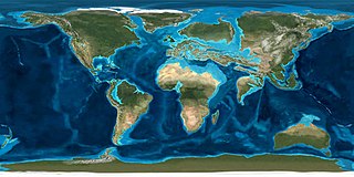
The Eocene Epoch is a geological epoch that lasted from about 56 to 33.9 million years ago (Ma). It is the second epoch of the Paleogene Period in the modern Cenozoic Era. The name Eocene comes from the Ancient Greek ἠώς and καινός and refers to the "dawn" of modern ('new') fauna that appeared during the epoch.

Jet streams are fast flowing, narrow, meandering air currents in the atmospheres of the Earth, Venus, Jupiter, Saturn, Uranus, and Neptune. On Earth, the main jet streams are located near the altitude of the tropopause and are westerly winds. Jet streams may start, stop, split into two or more parts, combine into one stream, or flow in various directions including opposite to the direction of the remainder of the jet.

In physical geography, tundra is a type of biome where tree growth is hindered by frigid temperatures and short growing seasons. The term tundra comes through Russian тундра from the Kildin Sámi word тӯндар meaning "uplands", "treeless mountain tract". There are three regions and associated types of tundra: Arctic tundra, alpine tundra, and Antarctic tundra.

The cryosphere is an all-encompassing term for the portions of Earth's surface where water is in solid form, including sea ice, lake ice, river ice, snow cover, glaciers, ice caps, ice sheets, and frozen ground. Thus, there is a wide overlap with the hydrosphere. The cryosphere is an integral part of the global climate system with important linkages and feedbacks generated through its influence on surface energy and moisture fluxes, clouds, precipitation, hydrology, atmospheric and oceanic circulation. Through these feedback processes, the cryosphere plays a significant role in the global climate and in climate model response to global changes. Approximately 10% of the Earth's surface is covered by ice, but this is rapidly decreasing. The term deglaciation describes the retreat of cryospheric features. Cryology is the study of cryospheres.
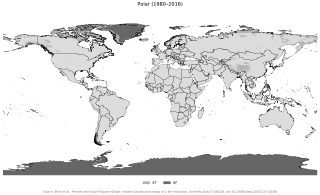
The polar climate regions are characterized by a lack of warm summers but with varying winters. Every month a polar climate has an average temperature of less than 10 °C (50 °F). Regions with a polar climate cover more than 20% of the Earth's area. Most of these regions are far from the equator and near the poles, and in this case, winter days are extremely short and summer days are extremely long. A polar climate consists of cool summers and very cold winters, which results in treeless tundra, glaciers, or a permanent or semi-permanent layer of ice. It is identified with the letter E in the Köppen climate classification.
The Western Antarctic Ice Sheet (WAIS) is the segment of the continental ice sheet that covers West Antarctica, the portion of Antarctica on the side of the Transantarctic Mountains that lies in the Western Hemisphere. The WAIS is classified as a marine-based ice sheet, meaning that its bed lies well below sea level and its edges flow into floating ice shelves. The WAIS is bounded by the Ross Ice Shelf, the Ronne Ice Shelf, and outlet glaciers that drain into the Amundsen Sea.

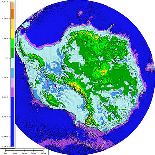
The Antarctic ice sheet is one of the two polar ice caps of Earth. It covers about 98% of the Antarctic continent and is the largest single mass of ice on Earth, with an average thickness of over 2 kilometers. Separate to the Antarctic sea ice it covers an area of almost 14 million square kilometres and contains 26.5 million cubic kilometres of ice. A cubic kilometer of ice weighs approximately 0.92 metric gigatonnes, meaning that the ice sheet weighs about 24,380,000 gigatonnes. It holds approximately 61% of all fresh water on Earth, equivalent to about 58 meters of sea level rise if all the ice were above sea level. In East Antarctica, the ice sheet rests on a major land mass, while in West Antarctica the bed can extend to more than 2,500 m below sea level.

The Arctic oscillation (AO) or Northern Annular Mode/Northern Hemisphere Annular Mode (NAM) is a weather phenomenon at the Arctic pole north of 20 degrees latitude. It is an important mode of climate variability for the Northern Hemisphere. The southern hemisphere analogue is called the Antarctic oscillation or Southern Annular Mode (SAM). The index varies over time with no particular periodicity, and is characterized by non-seasonal sea-level pressure anomalies of one sign in the Arctic, balanced by anomalies of opposite sign centered at about 37–45° N.
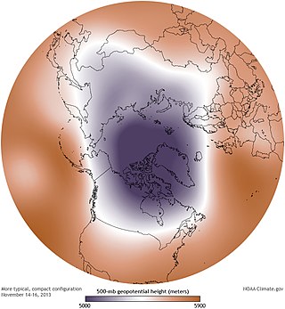
A circumpolar vortex, or simply polar vortex, is a large region of cold, rotating air that encircles both of Earth's polar regions. Polar vortices also exist on other rotating, low-obliquity planetary bodies. The term polar vortex can be used to describe two distinct phenomena; the stratospheric polar vortex, and the tropospheric polar vortex. The stratospheric and tropospheric polar vortices both rotate in the direction of the Earth's spin, but they are distinct phenomena that have different sizes, structures, seasonal cycles, and impacts on weather.

The Atlantic meridional overturning circulation (AMOC) is part of a global thermohaline circulation in the oceans and is the zonally integrated component of surface and deep currents in the Atlantic Ocean. It is characterized by a northward flow of warm, salty water in the upper layers of the Atlantic, and a southward flow of colder, deep waters. These "limbs" are linked by regions of overturning in the Nordic and Labrador Seas and the Southern Ocean, although the extent of overturning in the Labrador Sea is disputed. The AMOC is an important component of the Earth's climate system, and is a result of both atmospheric and thermohaline drivers.

Major environmental issues caused by contemporary climate change in the Arctic region range from the well-known, such as the loss of sea ice or melting of the Greenland ice sheet, to more obscure, but deeply significant issues, such as permafrost thaw, as well as related social consequences for locals and the geopolitical ramifications of these changes. The Arctic is likely to be especially affected by climate change because of the high projected rate of regional warming and associated impacts. Temperature projections for the Arctic region were assessed in 2007: These suggested already averaged warming of about 2 °C to 9 °C by the year 2100. The range reflects different projections made by different climate models, run with different forcing scenarios. Radiative forcing is a measure of the effect of natural and human activities on the climate. Different forcing scenarios reflect things such as different projections of future human greenhouse gas emissions.

The Antarctica cooling controversy was the result of an apparent contradiction in the observed cooling behavior of Antarctica between 1966 and 2000, which became part of the public debate in the global warming controversy, particularly between advocacy groups of both sides in the public arena including politicians, as well as the popular media. In his novel State of Fear, Michael Crichton asserted that the Antarctic data contradicted global warming. The few scientists who have commented on the supposed controversy state that there is no contradiction, while the author of the paper whose work inspired Crichton's remarks has said that Crichton misused his results. There is no similar controversy within the scientific community, as the small observed changes in Antarctica are consistent with the small changes predicted by climate models, and because the overall trend since comprehensive observations began is now known to be one of warming.

Polar amplification is the phenomenon that any change in the net radiation balance tends to produce a larger change in temperature near the poles than in the planetary average. This is commonly referred to as the ratio of polar warming to tropical warming. On a planet with an atmosphere that can restrict emission of longwave radiation to space, surface temperatures will be warmer than a simple planetary equilibrium temperature calculation would predict. Where the atmosphere or an extensive ocean is able to transport heat polewards, the poles will be warmer and equatorial regions cooler than their local net radiation balances would predict. The poles will experience the most cooling when the global-mean temperature is lower relative to a reference climate; alternatively, the poles will experience the greatest warming when the global-mean temperature is higher.

Antarctica is Earth's southernmost and least-populated continent. Situated almost entirely south of the Antarctic Circle and surrounded by the Southern Ocean, it contains the geographic South Pole. Antarctica is the fifth-largest continent, being about 40% larger than Europe, and has an area of 14,200,000 km2 (5,500,000 sq mi). Most of Antarctica is covered by the Antarctic ice sheet, with an average thickness of 1.9 km (1.2 mi).

Polar seas is a collective term for the Arctic Ocean and the southern part of the Southern Ocean. In the coldest years, sea ice can cover around 13 percent of the Earth's total surface at its maximum, but out of phase in the two hemispheres. The polar seas contain a huge biome with many organisms.

Climate change feedbacks are effects of global warming that amplify or diminish the effect of forces that initially cause the warming. Positive feedbacks enhance global warming while negative feedbacks weaken it. Feedbacks are important in the understanding of climate change because they play an important part in determining the sensitivity of the climate to warming forces. Climate forcings and feedbacks together determine how much and how fast the climate changes. Large positive feedbacks can lead to tipping points—abrupt or irreversible changes in the climate system—depending upon the rate and magnitude of the climate change.

Limacina rangii is a species of swimming sea snail in the family Limacinidae, which belong to the group commonly known as sea butterflies (Thecosomata).

Among the effects of climate change on oceans are an increase of ocean temperatures, more frequent marine heatwaves, ocean acidification, a rise in sea levels, sea ice decline, increased ocean stratification, reductions in oxygen levels, changes to ocean currents including a weakening of the Atlantic meridional overturning circulation. All these changes have knock-on effects which disturb marine ecosystems. The primary factor causing these changes is climate change due to human-caused emissions of greenhouse gases, such as carbon dioxide and methane. This leads inevitably to ocean warming, because the ocean is taking up most of the additional heat in the climate system. The ocean absorbs some of the extra carbon dioxide in the atmosphere and this causes the pH value of the ocean to drop. It is estimated that the ocean absorbs about 25% of all human-caused CO2 emissions.
Cretaceous polar forests were temperate forests that grew at polar latitudes during the final period of the Mesozoic Era, known as the Cretaceous Period 145–66 Ma. During this period, global average temperature was about 10 °C (18 °F) higher and carbon dioxide (CO2) levels were approximately 1000 parts per million (ppm), 2.5 times the current concentration in Earth's atmosphere. The abundance of atmospheric carbon dioxide had a very significant impact on global climate and Earth's natural systems as its concentration is considered one of the main factors in the development of a pronounced greenhouse Earth during the Cretaceous, with a very low average global temperature gradient. As a consequence, high paleolatitudes in both hemispheres were much warmer than at present. This temperature gradient was partly responsible for the lack of continental ice sheets in polar regions.
