The Patuxent Range is a major range of the Pensacola Mountains, Antarctica. It comprises the Thomas Hills, Anderson Hills, Mackin Table and various nunataks and ridges bounded by the Foundation Ice Stream, Academy Glacier and the Patuxent Ice Stream.
The Dominion Range is a broad mountain range, about 30 nautical miles long, forming a prominent salient at the juncture of the Beardmore and Mill glaciers in Antarctica. The range is part of the Queen Maud Mountains The range was discovered by the British Antarctic Expedition, 1907–09 and named by Ernest Shackleton for the Dominion of New Zealand, which generously aided the expedition.
The Behrendt Mountains is a group of mountains, 20 nautical miles long, aligned in the form of a horseshoe with the opening to the southwest, standing 7 nautical miles southwest of the Merrick Mountains in Ellsworth Land, Antarctica.

Bear Peninsula is a peninsula about 50 nautical miles long and 25 nautical miles wide which is ice-covered except for several isolated rock bluffs and outcrops along its margins, lying 3 nautical miles east of Martin Peninsula on Walgreen Coast, Marie Byrd Land, Antarctica.

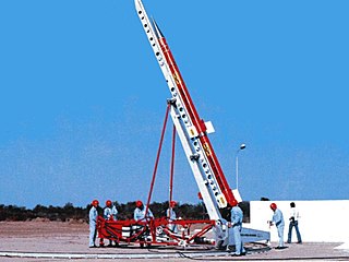
CELPA (El Chamical)(Centro de Experimentación y Lanzamiento de Proyectiles Autopropulsados) was a rocket launch site in Argentina, near El Chamical at 38°30′S66°19′W, in the La Rioja Province.

The Prince Charles Mountains are a major group of mountains in Mac. Robertson Land in Antarctica, including the Athos Range, the Porthos Range, and the Aramis Range. The highest peak is Mount Menzies, with a height of 3,228 m (10,591 ft). Other prominent peaks are Mount Izabelle and Mount Stinear. These mountains, together with other scattered peaks, form an arc about 420 km (260 mi) long, extending from the vicinity of Mount Starlight in the north to Goodspeed Nunataks in the south.

Sástago is a municipality located in the province of Zaragoza, Aragon, Spain. According to the 2004 census (INE), the municipality has a population of 1,307 inhabitants.

Finsterwalder Glacier is a glacier on the northwest side of Hemimont Plateau, 2 nautical miles wide and 10 nautical miles long, flowing southwest from the central plateau of Graham Land, Antarctica, toward the head of Lallemand Fjord. Its mouth lies between the mouths of Haefeli Glacier and Klebelsberg Glacier, the three glaciers merging with Sharp Glacier where the latter enters the fjord. It was first surveyed from the plateau in 1946–47 by the Falkland Islands Dependencies Survey, and named by them for Sebastian Finsterwalder and his son, Richard Finsterwalder, German glaciologists.

Altepexi Municipality is a municipality in the Mexican state of Puebla in south-eastern Mexico.
El Eje is a village and municipality in Catamarca Province, Belén Department, in northwestern Argentina.

Antevs Glacier, also known as North Heim Glacier, is a glacier on Arrowsmith Peninsula, Graham Land, flowing north between Seue Peaks and Boyle Mountains into Muller Ice Shelf, Lallemand Fjord. It was named by the United Kingdom Antarctic Place-Names Committee in 1960 after Ernst V. Antevs, American glacial geologist.
Barwick Valley is an ice-free valley north of Apocalypse Peaks, extending from Webb Glacier to Victoria Valley in Victoria Land, Antarctica. A large part of the valley has been designated an Antarctic Specially Protected Area because of its pristine condition.
Carroll Inlet is an inlet, 40 nautical miles long and 6 nautical miles wide, trending southeast along the coast of Ellsworth Land, Antarctica, between the Rydberg Peninsula and Smyley Island. The head of the inlet is divided into two arms by the presence of Case Island and is bounded to the east by Stange Ice Shelf.
Davis Valley is an ice-free valley just east of Floridas Ridge in north-east Dufek Massif, in the Pensacola Mountains, Antarctica.
Dybvadskog Peak is a sharp, somewhat isolated peak, 2,180 metres (7,150 ft) high, the westernmost of those rising above the ice surface just west of the southern part of the Founders Escarpment, in the Heritage Range of the Ellsworth Mountains, Antarctica. It was mapped by the United States Geological Survey from surveys and U.S. Navy air photos, 1961–66, and was named by the Advisory Committee on Antarctic Names after Olav Dybvadskog, a Norwegian glaciologist who was a member of the United States Antarctic Research Program South Pole—Queen Maud Land Traverse I, 1964–65.

Klebelsberg Glacier is a glacier, 7 nautical miles (13 km) long and 2 nautical miles (4 km) wide, situated at the south side of Finsterwalder Glacier and flowing from Hemimont Plateau northwestward between Armula Peak and Smilyan Bastion on Graham Land, Antarctica, toward the head of Lallemand Fjord. With Finsterwalder Glacier and Haefeli Glacier, its mouth merges with Sharp Glacier where the latter enters the fjord. It was first surveyed from the plateau in 1946–47 by the Falkland Islands Dependencies Survey, and named by them for Raimund von Klebelsberg, an Austrian glaciologist.
Seller Glacier is a well-defined glacier, 20 nautical miles (37 km) long and 4 nautical miles (7 km) wide flowing westward into Forster Ice Piedmont, western Antarctic Peninsula, just north of Flinders Peak. Roughly surveyed by British Graham Land Expedition (BGLE), 1936–37, and resurveyed by Falkland Islands Dependencies Survey (FIDS) in December 1958.


