Saxe-Weimar-Eisenach was a state of the German Empire, created as a duchy in 1809 by the merger of the Ernestine duchies of Saxe-Weimar and Saxe-Eisenach, which had been in personal union since 1741. It was raised to a grand duchy in 1815 by resolution of the Vienna Congress. In 1903, it officially changed its name to the Grand Duchy of Saxony, but this name was rarely used. The Grand Duchy came to an end in the German Revolution of 1918–19 with the other monarchies of the German Empire. It was succeeded by the Free State of Saxe-Weimar-Eisenach, which was merged into the new Free State of Thuringia two years later.

Bad Gottleuba-Berggießhübel is a spa town in the district Sächsische Schweiz-Osterzgebirge in Saxony, Germany. The municipality borders the Czech Republic in the south. The municipality was formed on 1 January 1999 by the merger of the former municipalities Bad Gottleuba, Berggießhübel, Langenhennersdorf, and Bahratal. Surrounded by forests and near a water dam, Bad Gottleuba-Berggießhübel has several facilities including a spa health park, a plant garden, and a heated open air pool.
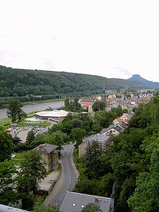
Bad Schandau is a spa town in Germany, in the Sächsische Schweiz-Osterzgebirge district of Saxony. It is situated on the right bank of the Elbe, at the mouth of the valley of the Kirnitzsch and in the area often described as Saxon Switzerland.
The Enz is a river flowing north from the Black Forest to the Neckar in Baden-Württemberg. It is 106 km long.

Neustadt in Sachsen is a town in the Sächsische Schweiz-Osterzgebirge district, in Saxony, Germany. It is situated near the border with the Czech Republic, 35 km east of Dresden (centre), and 23 km southwest of Bautzen. At Neustadt, there is an Observation Tower at Goetzinger's Height, one of the oldest lattice towers in the world.
Oberwiesenthal is a town and a ski resort in the district of Erzgebirgskreis in Saxony in Germany. It is situated in the Ore Mountains, on the border with the Czech Republic, 19 km south of Annaberg-Buchholz, and 23 km northeast of Karlovy Vary. At 914 metres (2,999 ft), it is the highest town in Germany. The Olympic and World Championships goldmedalist in ski jumping Jens Weißflog competed for SC Tractor Oberwiesenthal and Oberwiesenthaler SV.

Sebnitz is a town in the Sächsische Schweiz-Osterzgebirge district, in Saxony, Germany.

Wolkenstein is a town in the district Erzgebirgskreis, in Saxony, Germany. It is situated in the Ore Mountains, on the river Zschopau, 22 km southeast of Chemnitz.

Saxon Switzerland National Park, is a national park in the German Free State of Saxony, near the Saxon capital Dresden. It covers two areas of 93.5 km² (36.1 mi²) in the heart of the German part of the Elbe Sandstone Mountains, which is often called (the) Saxon Switzerland.

Ohorn is a municipality in the district of Bautzen, in Saxony, Germany. Ohorn is a governmentally accredited recreation locality.

The Ise is a 43 km (27 mi) long, almost natural river of East Lower Saxony and Saxony-Anhalt, Germany. It crosses the district of Gifhorn from north to south and discharges into the Aller at Gifhorn itself.

The Schwarza is a river in Lower Austria. It is the left headstream of the Leitha.
The Görlitz–Dresden railway is a two-track main line railway in the German state of Saxony, originally built and operated by the Saxon-Silesian Railway Company. It runs through Upper Lusatia from Dresden via Bischofswerda, Bautzen and Löbau to Görlitz. The line is part of the route from Dresden to Wrocław and Pan-European Transport Corridor III. The first section of the line opened in 1845 and it is one of the oldest lines in Germany.

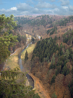
The Sebnitz is the left, larger headstream of the Lachsbach and runs through both the Czech Republic as well as the German state of Saxony. The upper section in the Czech Republic is known as Vilémovský potok in Czech and Wölmsdorfer Bach in German.
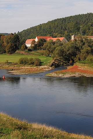
The Lachsbach, also called the Rathmannsdorfer Bach, is a river of Saxony, Germany. It is the largest, right-hand tributary of the Elbe in Saxon Switzerland.

The Speyerbach is a left tributary of the Rhine in the Palatinate part of Rhineland-Palatinate. In Speyer, the river split into Gießhübelbach and Woogbach. The Woogbach changes its name to Nonnenbach, then flows into Gießhübelbach shortly before the latter flows into the Rhine.

The Erms is a river of the karstified Swabian Alb range in Baden-Württemberg, Germany. It flows into the Neckar in Neckartenzlingen. On its way from the Karst spring to the next large municipality Bad Urach, a former Erms sedimented, especially during floods, no less than eight valley cataracts, where chemically precipitated travertine repeatedly drops c. 2 to 5 metres .

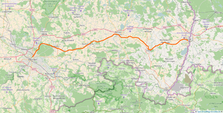
The Bautzen–Bad Schandau railway is a 64-kilometre long railway line in the state of Saxony, Germany, which connects Bautzen to Bad Schandau via Neukirch/Lausitz, Neustadt in Sachsen and Sebnitz. The railway was opened fully in 1898. The part between Neustadt in Sachsen and Bad Schandau is also known as Sebnitztalbahn. Today only the sections of Wilthen–Oberottendorf and Neustadt–Bad Schandau are still in operation.

The Isel is a 57.3 kilometres (35.6 mi) glacier-fed river in East Tyrol, Austria. The river flow varies with daily and seasonal temperature changes, and the riverbed is constantly shifting, creating a unique environment. The river's course runs along a geological fault running from NW to SE. It held a glacier during the last ice age, which has left boulders and gravel along the valley. There have been various proposals to dam and divert the water for use in generating hydroelectricity which have been opposed by environmentalists. Since 2015 the river has been designated a Natura 2000 site, which offers some protection. There is a hiking trail along the river, and it is known for excellent whitewater rafting conditions.