
Yukon is the smallest and westernmost of Canada's three territories. It also is the second-least populated province or territory in Canada, with a population of 44,238 as of March 2023. Whitehorse, the territorial capital, is the largest settlement in any of the three territories.

The Klondike Gold Rush was a migration by an estimated 100,000 prospectors to the Klondike region of Yukon, in north-western Canada, between 1896 and 1899. Gold was discovered there by local miners on August 16, 1896; when news reached Seattle and San Francisco the following year, it triggered a stampede of prospectors. Some became wealthy, but the majority went in vain. It has been immortalized in films, literature, and photographs.

The North-West Mounted Police (NWMP) was a Canadian paramilitary police force, established in 1873, to maintain order in the new Canadian North-West Territories (NWT) following the 1870 transfer of Rupert’s Land and North-Western Territory to Canada from the Hudson’s Bay Company, the Red River Rebellion and in response to lawlessness, demonstrated by the subsequent Cypress Hills Massacre and fears of United States military intervention. The NWMP combined military, police and judicial functions along similar lines to the Royal Irish Constabulary. A small, mobile police force was chosen to reduce potential for tensions with the United States and First Nations. The NWMP uniforms included red coats deliberately reminiscent of British and Canadian military uniforms.

Dawson City, officially the City of Dawson, is a town in the Canadian territory of Yukon. It is inseparably linked to the Klondike Gold Rush (1896–99). Its population was 1,577 as of the 2021 census, making it the second-largest town in Yukon.

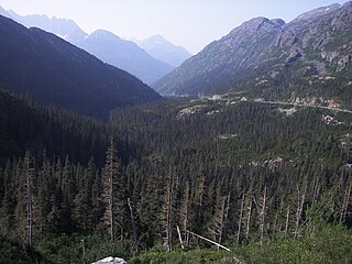
The Chilkoot Trail is a 33-mile (53 km) trail through the Coast Mountains that leads from Dyea, Alaska, in the United States, to Bennett, British Columbia, in Canada. It was a major access route from the coast to Yukon goldfields in the late 1890s. The trail became obsolete in 1899 when a railway was built from Dyea's neighbor port Skagway along the parallel White Pass trail.

Chilkoot Pass is a high mountain pass through the Boundary Ranges of the Coast Mountains in the U.S. state of Alaska and British Columbia, Canada. It is the highest point along the Chilkoot Trail that leads from Dyea, Alaska to Bennett Lake, British Columbia. The Chilkoot Trail was long a route used by the Tlingit for trade.

Bennett Lake is a lake in the Province of British Columbia and Yukon Territory in northwestern Canada, at an elevation of 2602 ft.. It is just north of the border with the United States state of Alaska, near the Alaskan port of Skagway.
White Pass, also known as the Dead Horse Trail, is a mountain pass through the Boundary Ranges of the Coast Mountains on the border of the U.S. state of Alaska and the province of British Columbia, Canada. It leads from Skagway, Alaska, to the chain of lakes at the headwaters of the Yukon River, Crater Lake, Lake Lindeman, and Bennett Lake.
The Klondike Highway is a highway that runs from the Alaska Panhandle through the province of British Columbia and the territory of Yukon in Canada, linking the coastal town of Skagway, Alaska, to Dawson City, Yukon. Its route somewhat parallels the route used by prospectors in the 1898 Klondike Gold Rush.
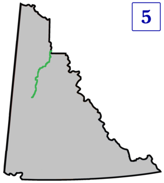
The Dempster Highway, also referred to as Yukon Highway 5 and Northwest Territories Highway 8, is a highway in Canada that connects the Klondike Highway in Yukon to Inuvik, Northwest Territories on the Mackenzie River delta. The highway crosses the Peel and the Mackenzie rivers using a combination of seasonal ferry services and ice bridges. Year-round road access from Inuvik to Tuktoyaktuk opened in November 2017, with the completion of the Inuvik–Tuktoyaktuk Highway, creating the first all-weather road route connecting the Canadian road network with the Arctic Ocean.

The Liard River of the North American boreal forest flows through Yukon, British Columbia and the Northwest Territories, Canada. Rising in the Saint Cyr Range of the Pelly Mountains in southeastern Yukon, it flows 1,115 km (693 mi) southeast through British Columbia, marking the northern end of the Rocky Mountains and then curving northeast back into Yukon and Northwest Territories, draining into the Mackenzie River at Fort Simpson, Northwest Territories. The river drains approximately 277,100 km2 (107,000 sq mi) of boreal forest and muskeg.

James Morrow Walsh was a North-West Mounted Police (NWMP) officer and the first commissioner of Yukon.
Charles Constantine was a Canadian North-West Mounted Police officer and superintendent, from Bradford, Yorkshire.

The Rocky Mountain Trench, also known as the Valley of a Thousand Peaks or simply the Trench, is a large valley on the western side of the northern part of North America's Rocky Mountains. The Trench is both visually and cartographically a striking physiographic feature extending approximately 1,600 km (1,000 mi) from Flathead Lake, Montana, to the Liard River, just south of the British Columbia–Yukon border near Watson Lake, Yukon. The trench bottom is 3–16 km (1.9–9.9 mi) wide and is 600–900 m (2,000–3,000 ft) above sea level. The general orientation of the Trench is an almost straight 150/330° geographic north vector and has become convenient as a visual guide for aviators heading north or south.

The Kechika River is a tributary of the Liard River, about 300 kilometres (190 mi) long, in northern British Columbia, Canada. The Kechika flows generally northwest through the northernmost section of the Rocky Mountain Trench before turning east to join the Liard, a major branch of the Mackenzie River system. The river's 22,700 km2 (8,800 sq mi) drainage basin is characterized by high glaciated peaks, boreal forest, and open tundra. With no settlements, roads or dams along its course, the Kechika is considered "one of British Columbia's finest examples of wilderness and undisturbed wildlife habitat."
Pink Mountain may refer to an unincorporated community on the Alaska Highway, a nearby mountain, or the hunting guiding territory west of the mountain.

The Yukon Field Force, later termed the Yukon Garrison, was a unit of 203 officers and men from the Permanent Force of the Canadian Militia that served in the Yukon between 1898 and 1900. The force was created in the wake of the Klondike Gold Rush in response to fears that the United States might attempt to seize the region. It left Ottawa on May 6, 1898, travelling by rail and sea to the port of Glenora in British Columbia. From there, the unit made an arduous journey of 890 kilometres (550 mi) on foot and using makeshift boats to Fort Selkirk, where they established their headquarters. A detachment of 72 men was sent to the boom town of Dawson City to support the North-West Mounted Police, with duties that included guarding the gold deposits of the local banks. As the fears of an annexation reduced, pressures grew for the recall of the force. The force was halved in size in July 1898 and the remainder were finally withdrawn in June 1900.
The Muskwa-Kechika Management Area is a provincially run tract of land in the far north of British Columbia. It has an advisory board that advises the government on land-use decisions. Established by provincial government legislation in 1998, the area is meant to be preserved as a wild area, but development is not forbidden. The land is divided into different zones, with varying levels of protection, although the whole area is supposed to be used according to an overall plan. The original plan called for 25% of the land to be turned into provincial parks, 60% to become "special management zones" where mining and oil and gas drilling was to be allowed, and 15% to become "special wildland zones" where logging is prohibited. The original size of the M-KMA was 4,450,000 hectares however in 2000 with the approval of the Mackenzie Land and Resource Management Plan (LRMP) over 1,900,000 hectares were added to the M-KMA creating a total area of 6,400,000 hectares, which is approximately the size of the US state of Maine, or the island of Ireland, or seven times the size of Yellowstone National Park in the United States.
Finlay Forks, is the confluence of the Finlay River and Parsnip River. The Finlay Bay Recreation Site, on the southeast bank, is about three kilometres (1.9 mi) southeast of the former settlement that is now submerged beneath Williston Lake. Like the river, it was named after explorer John Finlay. The access road from Mackenzie is called the Parsnip West FSR.

The history of the North-West Mounted Police in the Canadian north describes the activities of the North-West Mounted Police in the North-West Territories at the end of the 19th century and the start of the 20th. The mounted police had been established to control the prairies along the Canadian-United States border in 1873, but were then also deployed to control the Yukon region during the Klondike Gold Rush, and subsequently expanded their operations into the Hudson Bay area and the far north. The force was amalgamated in 1920 to form part of the new Royal Canadian Mounted Police, who continued their predecessors' work across the region.
