Polygonal, patterned ground is quite common in some regions of Mars.[1][2][3][4][5][6][7] It is commonly believed to be caused by the sublimation of ice from the ground. Sublimation is the direct change of solid ice to a gas. This is similar to what happens to dry ice on the Earth. Places on Mars that display polygonal ground may indicate where future colonists can find water ice. Low center polygons have been proposed as a marker for ground ice.[8]
On Mars, researches have found patterned ground that formed from fractures and patterned ground formed by the arrangement of boulders. It is not yet clear what caused boulders to form patterns, but it does not seem that fractures caused the boulders to move around.[13]
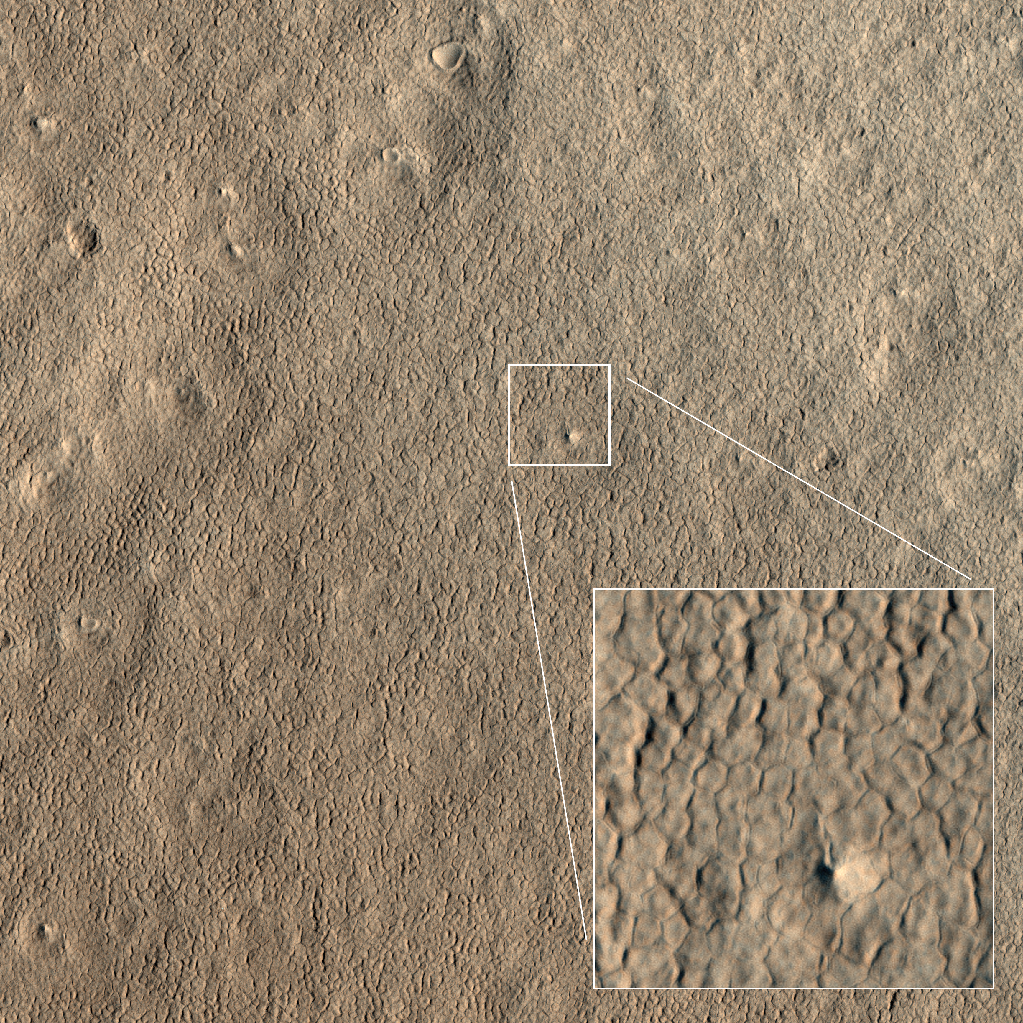
Surface showing appearance with and without mantle covering, as seen by HiRISE, under the HiWish program. Location is Terra Sirenum in Phaethontis quadrangle.
Close up view of mantle, as seen by HiRISE under the HiWish program. Mantle may be composed of ice and dust that fell from the sky during past climatic conditions. Location is Cebrenia quadrangle.
Physics
A similar process occurs on Nile crocodiles. Their snout skins crack during embryo development, forming polygonal patterns.
Unlike mudcracks, which are dominated by T-junctions, polygonal terrain is dominated by Y-junctions. It is formed by repeatedly annealing the crack pattern, as the same ground is partially melted every summer, then frozen every winter, until thousands of years later, it settles into a thermodynamically favored state, which is dominated by Y-junctions. This is similar to columnar jointing.[14]
Polygons in Mare Australe quadrangle
Wide view of crater containing polygons with frost in the low parts, as seen by HiRISE under the HiWish program
Closer view of polygons with frost in the low parts, as seen by HiRISE under the HiWish program
Close view of polygons with frost in the low parts, as seen by HiRISE under the HiWish program Circular shapes are also visible.
High center polygons, shown with arrows, as seen by HiRISE under HiWish program. Location is Casius quadrangle. Image enlarged with HiView.
Scalloped terrain labeled with both low center polygons and high center polygons, as seen by HiRISE under HiWish program Location is Casius quadrangle. Image enlarged with HiView.
Low center polygons, as seen by HiRISE under HiWish program Location is Casius quadrangle. Image enlarged with HiView.
High and low center polygons, as seen by HiRISE under HiWish program Location is Casius quadrangle. Image enlarged with HiView.
High and low-centered polygons in a region of scalloped terrain, as seen by HiRISE under HiWish program
Low-centered polygons in a region of scalloped terrain, as seen by HiRISE under HiWish program
Patterned ground in Hellas, as seen by HiRISE under HiWish program The rectangle shows the size of a football field.
Close view of snout of glacier, as seen by HiRISE under the HiWish program High center polygons are visible. Box shows size of football field.
Close view of high center polygons near glacier, as seen by HiRISE under the HiWish program Box shows size of football field.
Sizes and formation of polygonal ground
Fractured polygonal ground is generally divided into two kinds: high center and low center. The middle of a high center polygon is 10 meters across and its troughs are 2–3 meters wide. Low center polygons are 5–10 meters across and the boundary ridges are 3–4 meters wide.[15][16][17]
Drawing with a side view showing sizes of high and low center polygons
High center polygons are higher in the center and lower along their boundaries. It forms from increased sublimation around cracks in a surface. Cracks are common in ice-rich surfaces.[18][19][20][21][22][5][23]
The cracks provide a place of increased surface area for sublimation. After a time the narrow cracks widen to become troughs.
Drawing showing formation of high center polygons. Ice-rich mantle develops a lag deposit. Stresses create cracks. Increased sublimation along cracks causes troughs.
Low center polygons are thought to develop from the high center polygons. The troughs along the edges of high center polygons may become filled with sediment. This thick sediment will retard sublimation, so more sublimation will take place in the center that is protected by a thinner lag deposit. In time, the middle becomes lower than the outer parts. The sediments from the troughs will turn into ridges.[15]
Diagram showing how low center polygons develop. The troughs of high center polygons fill with sediment; consequently there is much less sublimation there and more at the center.
High-center polygons, as seen by HiRISE under HiWish program Image is of the top of a debris apron in Deuteronilus Mensae.
Close up of field of high center polygons with scale, as seen by HiRISE under HiWish program Note: the black box is the size of a football field.
Close-up of high center polygons seen by HiRISE under HiWish program Note: the black box is the size of a football field.
Close-up of high center polygons seen by HiRISE under HiWish program Troughs between polygons are easily visible in this view.
Wide view of high center polygons, as seen by HiRISE under HiWish program
Close view of high center polygons, as seen by HiRISE under HiWish program Centers of polygons are labeled.
Large polygons, as seen by HiRISE under HiWish program
Clastic patterned ground
Many areas of patterned ground were formed by boulders. For, as yet unknown reasons, boulders are often arranged in various shapes that include polygons. A study around Lomonosov Crater found that they were not caused by fracture networks.[13] Clastic patterned ground has been found across the Northern Plains.[24][25][26][27] Another site was Elysium Planitia.[28] Researchers also found this terrain in the Argyre Basin (Argyre quadrangle).[29][30]
Latitude dependent mantle
Much of the Martian surface is covered with a thick ice-rich, mantle layer that has fallen from the sky a number of times in the past. It fell as snow and ice-coated dust. This mantle layer is called "latitude dependent mantle" because its occurrence is related to the latitude. It is this mantle that cracks and then forms polygonal ground.
The mantle layer lasts for a very long time before all the ice is gone because a protective lag deposit forms on the top.[31] The mantle contains ice and dust. After a certain amount of ice disappears from sublimation the dust stays on the top, forming the lag deposit.[32][33][34]
Mantle forms when the Martian climate is different than the present climate. The tilt or obliquity of the axis of the planet changes a great deal.[35][36][37] The Earth’s tilt changes little because our rather large moon stabilizes the Earth. Mars only has two very small moons that do not possess enough gravity to stabilize its tilt. When the tilt of Mars exceeds around 40 degrees (from today's 25 degrees), ice is deposited in certain bands where much mantle exists today.[38][39]
Other surface features
Another type of surface is called "brain terrain" as it looks like the surface of a human brain. Brain terrain lies under polygonal ground when the two are both visible in a region.[15]
Open and closed-cell brain terrain, as seen by HiRISE, under HiWish program.
Brain terrain being formed from a thicker layer, as seen by HiRISE under HiWish program. Arrows show the thicker unit breaking up into small cells.
Since the top, polygon layer is fairly smooth although the underlying brain terrain is irregular; it is believed that the mantle layer that contains the polygons is 10–20 meters thick.[40]
"Basketball terrain" is another expression of the surface of Mars. At certain distances it looks like a basketball’s surface. Close-up pictures have revealed it to consist of piles of rocks.[41][42][43][44] Many ideas have been advanced to explain how these piles of rocks are formed.[45][46]
Many steep surfaces in latitude bands near 40 degrees North and South contain gullies. Some of the gullies show polygons. These have been called "gullygons."[40]
Close-up of gully showing multiple channels and patterned ground, as seen by HiRISE under the HiWish program. Locations is Phaethontis quadrangle.
Close-up of gully alcove showing "gullygons" (polygonal patterned ground near gullies), as seen by HiRISE under HiWish program Note this is an enlargement of a previous image.
Polygons around gullies in crater, as seen by HiRISE under HiWish program Location is Hellas quadrangle.
Complex polygonal patterned ground
Wide view of polygons, as seen by HiRISE under HiWish program Parts of this image are enlarged in following images. The location is the Noachis quadrangle
Polygons, as seen by HiRISE under HiWish program
Close view of polygons, as seen by HiRISE under HiWish program Arrow point to boulders that sit inside of small craters.
Close view of polygons, as seen by HiRISE under HiWish program
Close view of polygons, as seen by HiRISE under HiWish program
On the Earth
On the Earth, polygonal, patterned ground is present in ice-rich ground, especially in polar regions.
Patterned ground on Earth.
Patterned ground in Alaska
Patterned ground in Alaska. The center is lower; hence full of water. This scene is like low-center polygons on Mars—but with water.
↑ Kostama, V.-P.; Kreslavsky, M. A.; Head, J. W. (June 2006). "Recent high-latitude icy mantle in the northern plains of Mars: Characteristics and ages of emplacement". Geophysical Research Letters. 33 (11) 2006GL025946. Bibcode:2006GeoRL..3311201K. doi:10.1029/2006GL025946.
↑ Milliken, R. E.; Mustard, J. F.; Goldsby, D. L. (June 2003). "Viscous flow features on the surface of Mars: Observations from high-resolution Mars Orbiter Camera (MOC) images". Journal of Geophysical Research: Planets. 108 (E6) 2002JE002005. Bibcode:2003JGRE..108.5057M. doi:10.1029/2002JE002005.
↑ Seibert, N.; Kargel, J. (2001). "Small-scale martian polygonal terrain: Implications for liquid surface water". Geophys. Res. Lett. 28 (5): 899–902. Bibcode:2001GeoRL..28..899S. doi:10.1029/2000gl012093.
↑ Soare, Richard J.; Gallagher, Colman J.; Garvin, James B.; Williams, Jean-Pierre; Hepburn, Adam J.; Costard, Francois; Koutnik, Michelle; Li, An Y. (November 2025). "'Icy' scarp exposures, 'ice-rich' overburdens and ephemeral climate-warming at Mars' mid-latitudes in the very late Amazonian epoch". Icarus. 441 116727. doi:10.1016/j.icarus.2025.116727.
↑ Mustard, John F.; Cooper, Christopher D.; Rifkin, Moses K. (July 2001). "Evidence for recent climate change on Mars from the identification of youthful near-surface ground ice". Nature. 412 (6845): 411–414. Bibcode:2001Natur.412..411M. doi:10.1038/35086515. PMID11473309.
↑ Kreslavsky, M.A., Head, J.W., 2002. High-latitude Recent Surface Mantle on Mars: New Results from MOLA and MOC. European Geophysical Society XXVII, Nice.
1 2 3 Levy, J.; Head, J.; Marchant, D. (2009). "Concentric crater fill in Utopia Planitia: History and interaction between glacial "brain terrain" and periglacial mantle processes". Icarus. 202 (2): 462–476. Bibcode:2009Icar..202..462L. doi:10.1016/j.icarus.2009.02.018.
↑ Mutch, T. A.; Grenander, S. U.; Jones, K. L.; Patterson, W.; Arvidson, R. E.; Guinness, E. A.; Avrin, P.; Carlston, C. E.; Binder, A. B.; Sagan, C.; Dunham, E. W.; Fox, P. L.; Pieri, D. C.; Huck, F. O.; Rowland, C. W.; Taylor, G. R.; Wall, S. D.; Kahn, R.; Levinthal, E. C.; Liebes, S.; Tucker, R. B.; Morris, E. C.; Pollack, J. B.; Saunders, R. S.; Wolf, M. R. (17 December 1976). "The Surface of Mars: The View from the Viking 2 Lander". Science. 194 (4271): 1277–1283. Bibcode:1976Sci...194.1277M. doi:10.1126/science.194.4271.1277. PMID17797083.
↑ Mutch, Thomas A.; Arvidson, Raymond E.; Binder, Alan B.; Guinness, Edward A.; Morris, Elliot C. (30 September 1977). "The geology of the Viking Lander 2 site". Journal of Geophysical Research. 82 (28): 4452–4467. Bibcode:1977JGR....82.4452M. doi:10.1029/js082i028p04452.
↑ Marchant, David R.; Head, James W. (December 2007). "Antarctic dry valleys: Microclimate zonation, variable geomorphic processes, and implications for assessing climate change on Mars". Icarus. 192 (1): 187–222. Bibcode:2007Icar..192..187M. doi:10.1016/j.icarus.2007.06.018.
↑ Balme, M.R.; Gallagher, C.J.; Hauber, E. (June 2013). "Morphological evidence for geologically young thaw of ice on Mars: A review of recent studies using high-resolution imaging data". Progress in Physical Geography: Earth and Environment. 37 (3): 289–324. Bibcode:2013PrPG...37..289B. doi:10.1177/0309133313477123.
↑ Gallagher, C.; Balme, M.R.; Conway, S.J.; Grindrod, P.M. (January 2011). "Sorted clastic stripes, lobes and associated gullies in high-latitude craters on Mars: Landforms indicative of very recent, polycyclic ground-ice thaw and liquid flows". Icarus. 211 (1): 458–471. Bibcode:2011Icar..211..458G. doi:10.1016/j.icarus.2010.09.010.
↑ Johnsson, A.; Reiss, D.; Hauber, E.; Zanetti, M.; Hiesinger, H.; Johansson, L.; Olvmo, M. (March 2012). "Periglacial mass-wasting landforms on Mars suggestive of transient liquid water in the recent past: Insights from solifluction lobes on Svalbard". Icarus. 218 (1): 489–505. Bibcode:2012Icar..218..489J. doi:10.1016/j.icarus.2011.12.021.
↑ Orloff, T.; Kreslavsky, M.; Asphaug, E.; Korteniemi, J. (19 November 2011). "Boulder movement at high northern latitudes of Mars". Journal of Geophysical Research. 116 (E11) E11006. Bibcode:2011JGRE..11611006O. doi:10.1029/2011je003811.
↑ Banks, Maria E.; McEwen, Alfred S.; Kargel, Jeffrey S.; Baker, Victor R.; Strom, Robert G.; Mellon, Michael T.; Gulick, Virginia C.; Keszthelyi, Laszlo; Herkenhoff, Kenneth E.; Pelletier, Jon D.; Jaeger, Windy L. (December 2008). "High Resolution Imaging Science Experiment (HiRISE) observations of glacial and periglacial morphologies in the circum-Argyre Planitia highlands, Mars". Journal of Geophysical Research: Planets. 113 (E12) 2007JE002994. Bibcode:2008JGRE..11312015B. doi:10.1029/2007je002994.
↑ Soare, R.J.; Conway, S.J.; Gallagher, C.; Dohm, J.M. (January 2016). "Sorted (clastic) polygons in the Argyre region, Mars, and possible evidence of pre- and post-glacial periglaciation in the Late Amazonian Epoch". Icarus. 264: 184–197. Bibcode:2016Icar..264..184S. doi:10.1016/j.icarus.2015.09.019.
↑ Marchant, D.R.; Lewis, A.R.; Phillips, W.M.; Moore, E.J.; Souchez, R.A.; Denton, G.H.; Sugden, D.E.; Potter Jr., N.; Landis, G.P. (June 2002). "Formation of patterned ground and sublimation till over Miocene glacier ice in Beacon Valley, southern Victoria Land, Antarctica". Geological Society of America Bulletin. 114 (6): 718–730. Bibcode:2002GSAB..114..718M. doi:10.1130/0016-7606(2002)114<0718:fopgas>2.0.co;2.
↑ Levy, J.; Head, J.; Marchant, D.; Kowalewski, D. (2008). "Identification of sublimation-type thermal contraction crack polygons at the proposed NASA Phoenix landing site: Implications for substrate properties and climate-driven morphological evolution". Geophys. Res. Lett. 35 (4): L04202. Bibcode:2008GeoRL..35.4202L. doi:10.1029/2007GL032813.
1 2 Levy, Joseph S.; Marchant, David R.; Head, James W. (March 2010). "Thermal contraction crack polygons on Mars: A synthesis from HiRISE, Phoenix, and terrestrial analog studies". Icarus. 206 (1): 229–252. Bibcode:2010Icar..206..229L. doi:10.1016/j.icarus.2009.09.005.
↑ Mellon, Michael T.; Arvidson, Raymond E.; Marlow, Jeffrey J.; Phillips, Roger J.; Asphaug, Erik (March 2008). "Periglacial landforms at the Phoenix landing site and the northern plains of Mars". Journal of Geophysical Research: Planets. 113 (E3) 2007JE003039. Bibcode:2008JGRE..113.0A23M. doi:10.1029/2007je003039.
This page is based on this Wikipedia article Text is available under the CC BY-SA 4.0 license; additional terms may apply. Images, videos and audio are available under their respective licenses.
 Surface showing appearance with and without mantle covering, as seen by HiRISE, under the HiWish program. Location is Terra Sirenum in Phaethontis quadrangle.
 Close up view of mantle, as seen by HiRISE under the HiWish program. Mantle may be composed of ice and dust that fell from the sky during past climatic conditions. Location is Cebrenia quadrangle.


