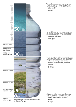
Brackish water, sometimes termed brack water, is water occurring in a natural environment that has more salinity than freshwater, but not as much as seawater. It may result from mixing seawater and fresh water together, as in estuaries, or it may occur in brackish fossil aquifers. The word comes from the Middle Dutch root brak. Certain human activities can produce brackish water, in particular civil engineering projects such as dikes and the flooding of coastal marshland to produce brackish water pools for freshwater prawn farming. Brackish water is also the primary waste product of the salinity gradient power process. Because brackish water is hostile to the growth of most terrestrial plant species, without appropriate management it can be damaging to the environment.

Salinity is the saltiness or amount of salt dissolved in a body of water, called saline water. It is usually measured in g/L or g/kg.
Biosalinity is the study and practice of using saline (salty) water for irrigating agricultural crops.
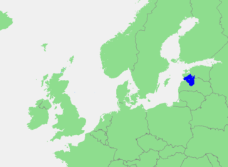
The Gulf of Riga, Bay of Riga, or Gulf of Livonia is a bay of the Baltic Sea between Latvia and Estonia.

A Ramsar site is a wetland site designated to be of international importance under the Ramsar Convention, also known as "The Convention on Wetlands", an international environmental treaty signed on 2 February 1971 in Ramsar, Iran, under the auspices of UNESCO. It came into force on 21 December 1975, when it was ratified by a sufficient number of nations. It provides for national action and international cooperation regarding the conservation of wetlands, and wise sustainable use of their resources. Ramsar identifies wetlands of international importance, especially those providing waterfowl habitat.
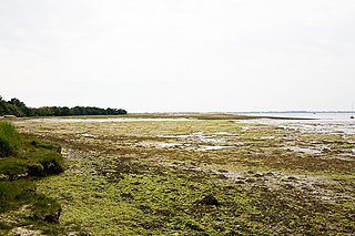
A tidal marsh is a marsh found along rivers, coasts and estuaries which floods and drains by the tidal movement of the adjacent estuary, sea or ocean. Tidal marshes experience many overlapping persistent cycles, including diurnal and semi-diurnal tides, day-night temperature fluctuations, spring-neap tides, seasonal vegetation growth and decay, upland runoff, decadal climate variations, and centennial to millennial trends in sea level and climate.

Saline water is water that contains a high concentration of dissolved salts. On the United States Geological Survey (USGS) salinity scale, saline water is saltier than brackish water, but less salty than brine. The salt concentration is usually expressed in parts per thousand and parts per million (ppm). The USGS salinity scale defines three levels of saline water. The salt concentration in slightly saline water is 1,000 to 3,000 ppm (0.1–0.3%); in moderately saline water is 3,000 to 10,000 ppm (0.3–1%); and in highly saline water is 10,000 to 35,000 ppm (1–3.5%). Seawater has a salinity of roughly 35,000 ppm, equivalent to 35 grams of salt per one liter of water. The saturation level is only nominally dependent on the temperature of the water. At 20 °C (68 °F) one liter of water can dissolve about 357 grams of salt, a concentration of 26.3 percent by weight. At 100 °C (212 °F), the amount of salt that can be dissolved in one liter of water increases to about 391 grams, a concentration of 28.1% w/w.

Lake Borgne is a lagoon of the Gulf of Mexico in southeastern Louisiana. Although early maps show it as a lake surrounded by land, coastal erosion has made it an arm of the Gulf of Mexico.

Littorina Sea is a geological brackish water stage of the Baltic Sea, which existed around 7500–4000 BP and followed the Mastogloia Sea, a transitional stage of the Ancylus Lake.
Yoldia Sea is a name given by geologists to a variable brackish water stage in the Baltic Sea basin that prevailed after the Baltic Ice Lake was drained to sea level during the Weichselian glaciation. Dates for the Yoldia sea are obtained mainly by radiocarbon dating material from ancient sediments and shore lines and from clay-varve chronology. Such dates tend to vary by as much as a thousand years in the literature, but were corrected in 2021 for the whole of the Holocene. The sea can not have existed before the final drainage to sea level of the Baltic Ice Lake in 11,620 cal. year BP.
Euryhaline organisms are able to adapt to a wide range of salinities. An example of a euryhaline fish is the short-finned molly, Poecilia sphenops, which can live in fresh water, brackish water, or salt water.

Osmotic power, salinity gradient power or blue energy is the energy available from the difference in the salt concentration between seawater and river water. Two practical methods for this are reverse electrodialysis (RED) and pressure retarded osmosis (PRO). Both processes rely on osmosis with membranes. The key waste product is brackish water. This byproduct is the result of natural forces that are being harnessed: the flow of fresh water into seas that are made up of salt water.

The Myakka River is a river in southwestern Florida. It arises near the Hardee-Manatee county line and flows southwest and then southeast through Manatee, Sarasota and Charlotte counties to Charlotte Harbor, an arm of the Gulf of Mexico. The river is 72 miles (116 km) long and has a drainage basin of 602 square miles, of which 314.7 square miles (815 km2) lies in Sarasota county. The last 20 miles (32 km) of the river is tidal and brackish.

Uchhali is a saltwater lake in Soan Sakaser Valley in the southern Salt Range area in the province of Punjab, Pakistan. This lake is formed due to the absence of drainage in the range.
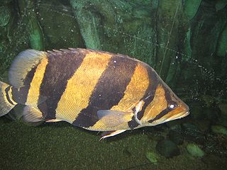
A brackish-water aquarium is an aquarium where the water is brackish (semi-salty). The range of "saltiness" varies greatly, from near freshwater to near marine and is often referred to as specific gravity (SG) or salinity. Brackish water aquaria is a popular specialization within the fishkeeping hobby. Many species of fish traded as freshwater species are actually true brackish species, for example mollies, Florida flagfish, and some cichlids such as chromides and black-chin tilapia. There are also several popular species traded purely as brackish water fish, including monos, scats, archerfish, and various species of pufferfish, goby, flatfish, and gar. Generally, aquarists need to maintain a specific gravity of around 1.005 to 1.010 depending on the species being kept, but practically all brackish water fish tolerate variations in salinity well, and some aquarists maintain that regularly fluctuating the salinity in the aquarium actually keeps the fish healthy and free of parasites.
Grazing marsh is a British Isles term for flat, marshy grassland in polders. It consists of large grass fields separated by fresh or brackish ditches, and is often important for its wildlife.
Pallinup River is a river located in the Great Southern region of Western Australia. It was previously known as Salt River.
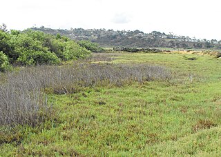
Brackish marshes develop from salt marshes where a significant freshwater influx dilutes the seawater to brackish levels of salinity. This commonly happens upstream from salt marshes by estuaries of coastal rivers or near the mouths of coastal rivers with heavy freshwater discharges in the conditions of low tidal ranges.
Classification of wetlands has been a problematical task, with the commonly accepted definition of what constitutes a wetland being among the major difficulties. A number of national wetland classifications exist. In the 1970s, the Ramsar Convention on Wetlands of International Importance introduced a first attempt to establish an internationally acceptable wetland classification scheme.

Salt pannes and pools are water retaining depressions located within salt and brackish marshes. Pools tend to retain water during the summer months between high tides, whereas pannes generally do not. Salt pannes generally start when a mat of organic debris is deposited upon existing vegetation, killing it. This creates a slight depression in the surrounding vegetation which retains water for varying periods of time. Upon successive cycles of inundation and evaporation the panne develops an increased salinity greater than that of the larger body of water. This increased salinity dictates the type of flora and fauna able to grow within the panne. Salt pools are also secondary formations, though the exact mechanism(s) of formation are not well understood; some have predicted they will increase in size and abundance in the future due to rising sea levels.


