Porlock Bay, Papua New Guinea

Last updated

Porlock Bay is a bay within Dyke Ackland Bay, Oro Province of Papua New Guinea named by Captain John Moresby after Porlock Bay in Somerset, England. [1]

Bay A recessed, coastal body of water connected to an ocean or lake

A bay is a recessed, coastal body of water that directly connects to a larger main body of water, such as an ocean, a lake, or another bay. A large bay is usually called a gulf, sea, sound, or bight. A cove is a type of smaller bay with a circular inlet and narrow entrance. A fjord is a particularly steep bay shaped by glacial activity.

Dyke Ackland Bay is a large bay in the Oro Province of Papua New Guinea. The bay extends from Cape Nelson to Cape Ward Hunt. Porlock Bay and Oro Bay are some of the smaller bays located within the larger bay. The bay was named by Captain John Moresby after his friend Sir Thomas Dyke Acland.

Oro Province Place in Papua New Guinea

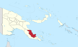
Oro Province, formerly Northern Province, is a coastal province of Papua New Guinea. The provincial capital is Popondetta. The province covers 22,800 km2, and has 176,206 inhabitants. The province shares land borders with Morobe Province to the northwest, Central Province to the west and south, and Milne Bay Province to the southeast. The province is located within the Papuan Peninsula.

The harbour, known as Porlock Harbour, within the bay was utilised by the American and Australian armed forces as a safe anchorage and supply depot during World War II. A battery of anti-aircraft guns was positioned at Cody's Point. [2]

United States Federal republic in North America

The United States of America (USA), commonly known as the United States or America, is a country comprising 50 states, a federal district, five major self-governing territories, and various possessions. At 3.8 million square miles, the United States is the world's third or fourth largest country by total area and is slightly smaller than the entire continent of Europe's 3.9 million square miles. With a population of over 327 million people, the U.S. is the third most populous country. The capital is Washington, D.C., and the largest city by population is New York City. Forty-eight states and the capital's federal district are contiguous in North America between Canada and Mexico. The State of Alaska is in the northwest corner of North America, bordered by Canada to the east and across the Bering Strait from Russia to the west. The State of Hawaii is an archipelago in the mid-Pacific Ocean. The U.S. territories are scattered about the Pacific Ocean and the Caribbean Sea, stretching across nine official time zones. The extremely diverse geography, climate, and wildlife of the United States make it one of the world's 17 megadiverse countries.

World War II 1939–1945 global war

World War II, also known as the Second World War, was a global war that lasted from 1939 to 1945. The vast majority of the world's countries—including all the great powers—eventually formed two opposing military alliances: the Allies and the Axis. A state of total war emerged, directly involving more than 100 million people from over 30 countries. The major participants threw their entire economic, industrial, and scientific capabilities behind the war effort, blurring the distinction between civilian and military resources. World War II was the deadliest conflict in human history, marked by 50 to 85 million fatalities, most of whom were civilians in the Soviet Union and China. It included massacres, the genocide of the Holocaust, strategic bombing, premeditated death from starvation and disease, and the only use of nuclear weapons in war.

Related Research Articles

Darling Harbour recreational and pedestrian precinct on the western edge of the Sydney central business district

Darling Harbour is a harbour adjacent to the city centre of Sydney, New South Wales, Australia. It is also a large recreational and pedestrian precinct that is situated on western outskirts of the Sydney central business district. Originally named Long Cove, the locality extends northwards from Chinatown, along both sides of Cockle Bay to King Street Wharf 3 on the east, and to the suburb of Pyrmont on the west. Cockle Bay is just one of the waterways that makes up Darling Harbour, which opens north into the much larger Port Jackson.

A39 road road

The A39 is an A road in south west England. It runs south-west from Bath in Somerset through Wells, Glastonbury, Street and Bridgwater. It then follows the north coast of Somerset, Devon and Cornwall through Williton, Minehead, Porlock, Lynmouth, Barnstaple, Bideford, Stratton, Camelford, Wadebridge and St Columb Major. It then joins the route of the A30 road for around 5 miles (8.0 km), re-emerging near Zelah to head for the south Cornish coast via Truro and Falmouth.

Lynmouth village in the United Kingdom

Lynmouth is a village in Devon, England, on the northern edge of Exmoor. The village straddles the confluence of the West Lyn and East Lyn rivers, in a gorge 700 feet (210 m) below Lynton, which was the only place to expand to once Lynmouth became as built-up as possible. The villages are connected by the Lynton and Lynmouth Cliff Railway, which works two cable-connected cars by gravity, using water tanks.

Porlock civil parish in England

Porlock is a coastal village in Somerset, England, 5 miles (8 km) west of Minehead. It has a population of 1,440.

Northumberland Islands island chain off the coast of Queensland, Australia

The Northumberland Islands are a scattered island chain off the eastern coast of Queensland, Australia.

Winter Harbour is a fishing village of 5 people on the northern tip of Vancouver Island, at the mouth of the Quatsino Sound, in British Columbia, Canada. It was named in the 19th century because of its eponymous bay that forms a safe natural harbour.

Cockle Bay (Sydney)

Cockle Bay is a small bay in inner-city Sydney, New South Wales, Australia. It is located on the western edge of the Sydney central business district.

Porlock Weir human settlement in United Kingdom

Porlock Weir, about 1.5 miles west of the inland village of Porlock, Somerset, England, is a small settlement around a harbour. Porlock means place of the port and Porlock Weir is its harbour. Weir refers to salmon stakes and traps that were situated along the shore. It is a popular visitor attraction.

The State Parks of New South Wales are eighteen protected areas in New South Wales, Australia reserved for camping, water sports and recreational uses. State Parks are maintained by the New South Wales Department of Lands and managed by community trust boards.

Omokoroa Place in Bay of Plenty, New Zealand

Omokoroa is a small urban area in the Western Bay of Plenty District of New Zealand. The suburb is considered part of Greater Tauranga, and is within the Bay of Plenty electorate. Omokoroa began as a small rural holiday village, but is expanding to be a commuter town, with a 25-minute drive to Tauranga City.

Trà Ôn is a rural district of Vĩnh Long Province in the Mekong Delta region of Vietnam. It is known particularly for its pomelos, which are called bưởi Năm Roi. As of 2003 the district had a population of 149,983. The district covers an area of 258 km². The district capital lies at Trà Ôn.

Ivongo Place in Ihorombe, Madagascar

Ivongo is a town and commune in Madagascar. It belongs to the district of Ivohibe, which is a part of Ihorombe Region. The population of the commune was estimated to be approximately 5,000 in 2001 commune census.

Port of Richards Bay

The Port of Richards Bay is located in Richards Bay harbour on the Indian Ocean coast of South Africa, and contains the Richards Bay Coal Terminal (RBCT) which is the largest coal export facility in Africa.

Porlock Bay

Porlock Bay is on the Bristol Channel, between Hurlstone Point and Porlock Weir in Somerset, England.

Durban Island island in Nunavut, Canada

Durban Island is a Canadian Arctic island located in Nunavut, Canada. It is one of Baffin Island's northeast offshore islands within Davis Strait's Merchants Bay. It is 36 km2 (14 sq mi) in size. Durban Harbour is on the island's southeast facing side. Nearby can be found the larger Padloping Island, and Auyuittuq National Park Reserve is also to the west on Baffin Island.

The Nukuhou River is a river of the Bay of Plenty Region of New Zealand's North Island. It flows north from its origins 20 kilometres (12 mi) southwest of Opotiki, reaching the Bay of Plenty at Ohiwa Harbour, halfway between Opotiki and Whakatane.

The International Map of the World was a project begun in 1913 to create a complete map of the world according to internationally agreed standards. Roads were depicted in red, towns and railways were depicted in black, and the labels were written in the Roman alphabet. The map was the brainchild of Albrecht Penck, a German geographer who first proposed it in 1891.

Lynmouth Lifeboat Station station for search and rescue operations at Lynmouth, Devon

Lynmouth Lifeboat Station was the base for Royal National Lifeboat Institution (RNLI) search and rescue operations at Lynmouth, Devon in England from 1869 until 1944. Its best known action was in 1899 when the lifeboat was taken 15 miles (24 km) across Exmoor before being launched to assist a ship in trouble.

The canton of Saint-Flour-2 is an administrative division of the Cantal department, southern France. It was created at the French canton reorganisation which came into effect in March 2015. Its seat is in Saint-Flour.

References

  1. As it was, Hydro International, retrieved 2015-06-05
  2. Porlock Harbour, PacificWrecks.com, retrieved 2015-06-05

Coordinates: 9°02′S149°00′E / 9.033°S 149.000°E / -9.033; 149.000

Geographic coordinate system Coordinate system

A geographic coordinate system is a coordinate system that enables every location on Earth to be specified by a set of numbers, letters or symbols. The coordinates are often chosen such that one of the numbers represents a vertical position and two or three of the numbers represent a horizontal position; alternatively, a geographic position may be expressed in a combined three-dimensional Cartesian vector. A common choice of coordinates is latitude, longitude and elevation. To specify a location on a plane requires a map projection.