
Robert Fulton was an American engineer and inventor who is widely credited with developing the world's first commercially successful steamboat, the North River Steamboat. In 1807, that steamboat traveled on the Hudson River with passengers from New York City to Albany and back again, a round trip of 300 nautical miles, in 62 hours. The success of his steamboat changed river traffic and trade on major American rivers.
Switzerland County is a county in the southeast corner of the U.S. state of Indiana. As of the 2020 United States Census, the population was 9,737. The county seat is Vevay, one of two incorporated towns in the county.

Clark County is a county in the U.S. state of Indiana, located directly across the Ohio River from Louisville, Kentucky. At the 2020 census, the population was 121,093. The county seat is Jeffersonville. Clark County is part of the Louisville/Jefferson County, KY–IN Metropolitan Statistical Area.

Jeffersonville is a city and the county seat of Clark County, Indiana, United States, situated along the Ohio River. Locally, the city is often referred to by the abbreviated name Jeff. It lies directly across the Ohio River to the north of Louisville, Kentucky, along I-65. The population was 49,447 at the 2020 census.
Portland is a historic district, neighborhood and former independent town northwest of downtown Louisville, Kentucky. It is situated along a bend of the Ohio River just below the Falls of the Ohio National Wildlife Conservation Area, where the river curves to the north and then to the south, thus placing Portland at the northern tip of urban Louisville. In its early days it was the largest of the six major settlements at the falls, the others being Shippingport and Louisville in Kentucky and New Albany, Clarksville, and Jeffersonville on the Indiana side. Its modern boundaries are the Ohio River along the northwest, north, and northeast, 10th Street at the far east, Market Street on the south, and the Shawnee Golf Course at the far west.
The Point was a thriving 19th century neighborhood in Louisville, Kentucky, east of Downtown Louisville and opposite Towhead Island along the Ohio River. It was also located north of the present day Butchertown area.
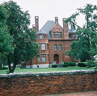
The Howard Steamboat Museum, or the Howard National Steamboat Museum, is located in Jeffersonville, Indiana, across from Louisville, Kentucky. House in the Howard Family mansion, it features items related to steamboat history and specifically, the Howard Shipyards of Jeffersonville, IN. The building is listed on the National Register of Historic Places.
The Louisville/Jefferson County metro government (balance) is a statistical entity in the U.S. state of Kentucky defined by the United States Census Bureau to represent the portion of the consolidated city-county of Louisville-Jefferson County that does not include any of the 83 separate incorporated places (municipalities) located within the city and county. It is made of the portion of Jefferson County that was the city of Louisville prior to the 2003 creation of Louisville Metro, plus a large swath of previously unincorporated territory.

The Fourteenth Street Bridge, also known as the Ohio Falls Bridge, Pennsylvania Railroad Bridge, Conrail Railroad Bridge or Louisville and Indiana (L&I) Bridge, is a truss drawbridge that spans the Ohio River, between Louisville, Kentucky and Clarksville, Indiana.

Louisville in the American Civil War was a major stronghold of Union forces, which kept Kentucky firmly in the Union. It was the center of planning, supplies, recruiting and transportation for numerous campaigns, especially in the Western Theater. By the end of the war, Louisville had not been attacked once, although skirmishes and battles, including the battles of Perryville and Corydon, Indiana, took place nearby.

Springville was a small town that existed from 1798 to 1811 in Charlestown Township, Clark County, Indiana, United States. It was named for the springs in the area that provided a good freshwater supply.

Jefferson General Hospital was the third-largest hospital during the American Civil War, located at Port Fulton, Indiana and was active between February 21, 1864, and December 1866. The land was owned by U.S. Senator from Indiana Jesse D. Bright. Bright was sympathetic to the Confederates, and was expelled from his position as Senator in 1862. Union authorities took the property without compensation, similar to what happened at Arlington National Cemetery.

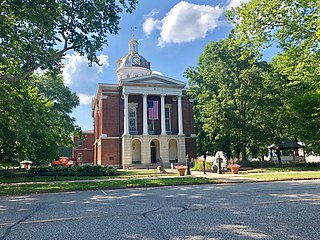
The Old Jeffersonville Historic District is located in Jeffersonville, Indiana, United States. It marks the original boundaries of Jeffersonville, and is the heart of modern-day downtown Jeffersonville. It was placed on the National Register of Historic Places in 1983. The area is roughly bounded by Court Avenue at the North, Graham Street on the east, the Ohio River at the south, and Interstate 65 at the west. In total, the district has 203 acres (0.8 km2), 500 buildings, 6 structures, and 11 objects. Several banks are located in the historic buildings in the district. The now defunct Steamboat Days Festival, held on the second weekend in September, used to be held on Spring Street and the waterfront. Jeffersonville's largest fire wiped out a block in the historic district on January 11, 2004, which destroyed the original Horner's Novelty store.

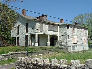
The Henry French House, also known as the Salmon-French House, is a historic house located in the Port Fulton area of Jeffersonville, Clark County, Indiana in the United States. It was built about 1832, and is a two-story, Federal style brick dwelling with a rear ell added about 1839 to form an I-house. It has some Colonial Revival style design elements.

Fort Nelson, built in 1781 by troops under George Rogers Clark including Captain Richard Chenoweth, was the second on-shore fort on the Ohio River in the area of what is now downtown Louisville, Kentucky. Fort-on-Shore, the downriver and first on-shore fort, had proved to be insufficient barely three years after it was established. In response to continuing attacks from Native Americans and the threat of British attacks during the Revolutionary War, Fort Nelson was constructed between what is currently Main Street and the river, with its main gate near Seventh Street. It was named after Thomas Nelson Jr., then the governor of Virginia.

Bethlehem is an unincorporated community in Bethlehem Township, Clark County, Indiana, United States, twenty-five miles up the Ohio River from Louisville, Kentucky. It was platted in 1812 and according to WPA records was presumably named for Bethlehem, Pennsylvania. Its first office was established on March 6, 1816. The community's post office is popular around Christmas with those wanting to have a Bethlehem postmark on Christmas letters and cards.

The Jeffersonville Township Public Library is a public library system in Jeffersonville, Indiana, United States comprising two locations: the main library at 211 East Court Avenue in Jeffersonville and the Clarksville Branch at 1312 Eastern Boulevard in Clarksville, Indiana. The rest of Clark County, Indiana is served by the Charlestown-Clark County Public Library system, with which the Jeffersonville library has a reciprocal borrowing agreement.

Jeffersonville Township is one of twelve townships in Clark County, Indiana. As of the 2010 census, its population was 59,062 and it contained 27,023 housing units.

Camp Joe Holt was a Union base during the American Civil War in Jeffersonville, Indiana, across the Ohio River from Louisville, Kentucky, on land that is now part of Clarksville, Indiana, near the Big Eddy. It was a major staging area for troops in the Western Theatre of the War, in preparation for invading the Confederate States of America. Its establishment was the first major step performed by Kentucky Unionists to keep Kentucky from seceding to the Confederacy.

Indiana, a state in the Midwest, played an important role in supporting the Union during the American Civil War. Despite anti-war activity within the state, and southern Indiana's ancestral ties to the South, Indiana was a strong supporter of the Union. Indiana contributed approximately 210,000 Union soldiers, sailors, and marines. Indiana's soldiers served in 308 military engagements during the war; the majority of them in the western theater, between the Mississippi River and the Appalachian Mountains. Indiana's war-related deaths reached 25,028. Its state government provided funds to purchase equipment, food, and supplies for troops in the field. Indiana, an agriculturally rich state containing the fifth-highest population in the Union, was critical to the North's success due to its geographical location, large population, and agricultural production. Indiana residents, also known as Hoosiers, supplied the Union with manpower for the war effort, a railroad network and access to the Ohio River and the Great Lakes, and agricultural products such as grain and livestock. The state experienced two minor raids by Confederate forces, and one major raid in 1863, which caused a brief panic in southern portions of the state and its capital city, Indianapolis.


