
Sandys Parish ( "sands") is one of the nine parishes of Bermuda. It is named for English aristocrat Sir Edwin Sandys (1561–1629), and hence there is no apostrophe in the name.

Southampton Parish is one of the nine parishes of Bermuda. It is named for Henry Wriothesley, 3rd Earl of Southampton (1573-1624).

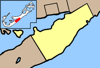
Warwick Parish is one of the nine parishes of Bermuda. It is named for Robert Rich, 2nd Earl of Warwick (1587-1658).
Paget Parish is one of the nine parishes of Bermuda. It is named for William Paget, 4th Baron Paget de Beaudesert (1572–1629).

Devonshire Parish is one of the nine parishes of Bermuda. Originally named "Cavendish Tribe" and later "Devonshire Tribe. It is named for William Cavendish, 1st Earl of Devonshire (1552–1626). He had never visited Bermuda himself, despite a parish being named after him. Devonshire Redoubt, on Castle Island, one of the Castle Harbour fortifications of St. George's Parish, was also named after him.

Hamilton Parish is one of the nine parishes of Bermuda. It was renamed for Scottish aristocrat James Hamilton, 2nd Marquess of Hamilton (1589-1625) when he purchased the shares originally held in the Virginia Company by Lucy, Countess of Bedford.
St. David's Head is a headland in the northeast of St. David's Island, Bermuda. It is the easternmost point of the territory, and is located in St. George's Parish. Actually two headlands, it is the site of Great Head Battery, one of the many forts that surround the site of the territory's first settlement in the early 17th century, which is now open to the public as a national monument.

Tobacco Bay is located in the far north of Bermuda. It lies on the Atlantic Ocean coast, close to the town of St. George's and to the historic Fort St. Catherine. One of Bermuda's national parks, it is a popular public beach. Snorkelling is a popular activity, as the bay has impressive underwater coral reefs, which explains its popularity with those who snorkel.
Church Bay is perhaps the most popular snorkelling beach in Bermuda. It is located in Church Bay Park off South Road in Southampton Parish on the main island. The reef is close to the shore and many colourful fish gather along it.
Crawl Island is an island of Bermuda.
Current Island is an island of Bermuda located in Sandys Parish.

Five Star Island is an island of Bermuda.
Grace Island is an island of Bermuda located in Warwick Parish.
Hospital Island is an island of Bermuda.
Hunts Island, Warwick is an island of Bermuda.
Malabar Island is an island of Bermuda.
Perot Island is an island of Bermuda.
Regatta Island is an island of Bermuda.
Riddell's Island is an island of Bermuda.
Watford Island is an island of Bermuda.


