
Jefferson County is a county located in the U.S. state of Washington. As of the 2020 census, the population was 32,977. The county seat and only incorporated city is Port Townsend. The county is named for Thomas Jefferson.
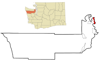
Marrowstone is a census-designated place (CDP) on Marrowstone Island in Jefferson County, Washington, United States. The population was 995 at the 2020 census. All Marrowstone addresses are in Nordland, Washington, and the ZIP code is 98358.

Port Townsend is a city on the Quimper Peninsula in Jefferson County, Washington, United States. The population was 10,148 at the 2020 United States Census. It is the county seat and only incorporated city of Jefferson County.
Keystone is a small unincorporated community on Whidbey Island in Island County, Washington, in the northwestern United States. It is near the Keystone ferry landing, a dock at Keystone Harbor for the Washington State Ferries' Coupeville to Port Townsend route. The route provides a maritime link for State Route 20 across Admiralty Inlet to the Olympic Peninsula. Since its establishment in the 1930s, the ferry route to Port Townsend was known as the Keystone-Port Townsend Ferry; the name was changed in 2010 at the suggestion of the Central Whidbey Chamber of Commerce in order to avoid confusion from tourists and visitors to Whidbey Island.
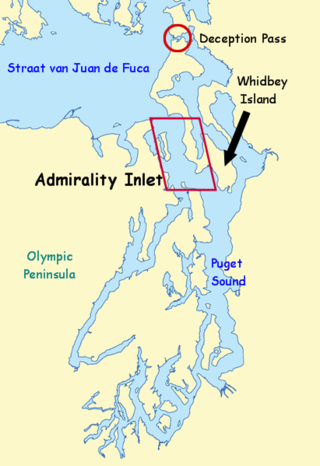
Admiralty Inlet is a strait in the U.S. state of Washington connecting the eastern end of the Strait of Juan de Fuca to Puget Sound. It lies between Whidbey Island and the northeastern part of the Olympic Peninsula.
The Kitsap Peninsula lies west of Seattle across Puget Sound, in Washington state in the Pacific Northwest. Hood Canal separates the peninsula from the Olympic Peninsula on its west side. The peninsula, a.k.a. "Kitsap", encompasses all of Kitsap County except Bainbridge and Blake Islands, as well as the northeastern part of Mason County and the northwestern part of Pierce County. The highest point on the Kitsap Peninsula is Gold Mountain. The U.S. Navy's Puget Sound Naval Shipyard, and Naval Base Kitsap are on the peninsula. Its main city is Bremerton.

Burrard Inlet is a shallow-sided fjord in the northwestern Lower Mainland, British Columbia, Canada. Formed during the last Ice Age, it separates the City of Vancouver and the rest of the lowland Burrard Peninsula to the south from the coastal slopes of the North Shore Mountains, which span West Vancouver and the City and District of North Vancouver to the north.
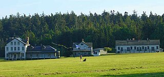
Fort Flagler State Park is a public recreation area that occupies the site of Fort Flagler, a former United States Army fort at the northern end of Marrowstone Island in Washington. The state park occupies 1,451 acres (587 ha) south of the entrance to Admiralty Inlet, and the Marrowstone Point Light stands adjacent. Port Townsend is visible to the northwest, the cranes at the Navy base on Indian Island to the west, and Whidbey Island to the east across Admiralty Inlet. Flagler Road terminates at the park entrance.

Fort Worden Historical State Park is located in Port Townsend, Washington, on 433 acres originally known as Fort Worden, a United States Army Coast Artillery Corps base constructed to protect Puget Sound from invasion by sea. Fort Worden was named after U.S. Navy Rear Admiral John Lorimer Worden, commander of USS Monitor during the famous Battle of Hampton Roads during the American Civil War.

Discovery Bay is an unincorporated community in Jefferson County, Washington. The community of Discovery Bay is an area near the intersection of U.S. Route 101 and State Route 20, at the foot of Discovery Bay – roughly midway between the larger communities of Port Townsend to the northeast and Sequim to the northwest. It is a mix of residential areas and commercial enterprises, including crabbing, oystering, clamming, timbering, security training and gravel extraction. A few restaurants and stores on US 101 near SR 20 primarily serve drivers and truckers along US 101.
Ocean Drive is a series of local toll roads in southern New Jersey, connecting Atlantic City to Cape May along barrier islands on the Atlantic Ocean. It consists of several roads and includes all five drawbridges owned by the Cape May County Bridge Commission.

The Quimper Peninsula is a narrow peninsula forming the most northeastern extent of the Olympic Peninsula of Washington state in the northwestern United States of America.

Saanich Inlet is a body of salt water that lies between the Saanich Peninsula and the Malahat highlands of Vancouver Island, British Columbia, Canada. Located just northwest of Victoria, the inlet is 25 km (16 mi) long, has a surface area of 67 km2 (26 sq mi), and its maximum depth is 226 m (741 ft). It extends from Satellite Channel in the north to Squally Reach and Finlayson Arm in the south. The only major tributary feeding the inlet is the Goldstream River.

Port Gardner, also known as Port Gardner Bay, is an inlet of Possession Sound on which the city of Everett, Washington is located. The Snohomish River flows into the north end of the bay.

Masset Inlet is a large saltwater bay located in the heart of the lowland of northern Graham Island, the northernmost and largest island of the Haida Gwaii islands on the North Coast of British Columbia, Canada. It is fed by several rivers, the largest of which is the Yakoun River, and is connected to the open sea of the Dixon Entrance by the narrow Masset Sound and Masset Harbour, which opens onto McIntyre Bay. The communities of Port Clements and Sewall are located on the shores of Masset Inlet. The community of Juskatla is located on Juus Ḵáahlii, the largest of Masset Inlet's arms. There are several islands in the inlet, the largest of which is Kumdis Island, at the inlet's egress to Masset Sound and just north of Port Clements. Masset Inlet helps form the isthmus of the Naikoon Peninsula.

Fort Townsend State Park is a public recreation area located two miles south of Port Townsend in Jefferson County, Washington. The state park occupies a third of the site of the original Fort Townsend built in 1856. The park includes 3,960 feet (1,210 m) of shoreline on Port Townsend Bay, picnicking and camping areas, 6.5 miles (10.5 km) of hiking trails, and facilities for boating, fishing, and crabbing.

USS Raeo (SP-588) was a United States Navy patrol vessel in commission from 1917 to 1919. Prior to her U.S. Navy service, she operated as the motor passenger vessel Raeo from 1908 to 1917. After the conclusion of her U.S. Navy career, she served as the fishery patrol vessel USFS Kittiwake in the United States Bureau of Fisheries fleet from 1919 to 1940 and as US FWS Kittiwake in the Fish and Wildlife Service fleet from 1940 to 1942 and from 1944 to at least 1945, and perhaps as late as 1948. During World War II, she again served in the U.S. Navy, this time as the yard patrol boat USS YP-199. She was the civilian fishing vessel Raeo from 1948 to 1957, then operated in various roles as Harbor Queen from 1957 to 1997. She became Entiat Princess in 1998 and as of 2009 was still in service.

Albion was a steamboat which ran on Puget Sound from 1898 to 1924.

Princess Louise was a sidewheel steamboat built in 1869. From 1869 to 1879 this ship was named Olympia. In 1879 the name was changed to Princess Louise, after Princess Louise, Duchess of Argyll, a daughter of Queen Victoria who was married to Marquess of Lorne (1845–1914), Governor General of Canada from 1878 to 1883. Princess Louise was the last sidewheeler to be operated commercially on the coast of British Columbia.

