Porta Capena

Last updated

Location of the gate Portecapene planrome.PNG
Location of the gate

The Porta Capena was a gate in the Servian Wall in Rome, Italy. The gate was located in the area of Piazza di Porta Capena, where the Caelian, Palatine and Aventine hills meet. Probably its exact position was between the entrance of Via di Valle delle Camene and the beginning of Via delle Terme di Caracalla (known as the "Archaeological Walk"), facing the curved side of the Circus Maximus. [1]

Contents

Nowadays Piazza di Porta Capena hosts the FAO Headquarters. Between 1937 and 2004, it was home to the obelisk of Axum.

History

The valley around what is now the avenue of the Baths of Caracalla was in ancient times covered with woods, caves, and freshwater springs. In this area (called the valley of the Camenae ), considered sacred and mysterious, it is said (and Livy punctually reports) that the peaceful king Numa Pompilius, the first successor of Romulus, had his nocturnal encounters with the goddess (or nymph) Egeria, who on those occasions provided him with all the necessary information for the institution of the rites most pleasing to each divinity, as well as the related priestly functions. Whether he was in good or bad faith, with this expedient the king managed to keep calm for several years a rough and ignorant people, who could not let off steam in the war. Therefore, this area can be considered the cradle of the religion of ancient Rome.

Its location and some testimonies suggest that the gate was originally called Camena and that its construction may even be earlier than that of the Servian Wall. The first historical-legendary mention dates back to the time of King Tullus Hostilius (mid-7th century BC): it refers to the fact that the funerary monument to Horatia – the sister of the Horatii, killed because she was guilty of falling in love of one of the Curiatii – was erected close to the gate.

In 489 BC, it was from Porta Capena that a multitude of young Volsci was driven out of Rome, while they waited for the games, according to the project of Coriolanus to foment their animosity against Rome and prepare for the subsequent war. [2]

In 312 BC the Appian Way was built, starting from the gate and having the city of Capua as its arrival point: for this reason, the name of the gate was changed into Capena and the whole area, already relevant for various reasons, assumed a very important role as a major point of transit and contact with southern Italy.

In literary evidence, the gate is also mentioned for another important event that deeply marked the history of Rome: as Livy reports, after the disastrous battle of Cannae, the Senate met to assess the situation "ad portam Capenam", which was one of the three meeting places of the assembly. [3]

The procession that introduced in Rome the goddess Cybele (the "Magna Mater"), which was one of the first representatives of foreign cults and rites later culminated with the affirmation of Christianity, also passed through Porta Capena.

Decline and destruction

According to Juvenal, in the 1st century A.D., the area of Porta Capena had lost its historical and legendary importance and had become a meeting place for beggars, especially those of the Jewish religion. [4] The last use of the gate was as a supporting arch for the passage of the Aqua Marcia aqueduct.

Porta Capena was destroyed and the entire area restructured by Emperor Caracalla; the access to Rome was later transferred a little further on, through the new Porta Appia which opened into the Aurelian Wall. Its remains, while no longer visible today, were traced during the excavations carried out in 1867.

Related Research Articles

<span class="mw-page-title-main">Velletri</span> Comune in Lazio, Italy

Velletri is an Italian comune in the Metropolitan City of Rome, approximately 40 km to the southeast of the city centre, located in the Alban Hills, in the region of Lazio, central Italy. Neighbouring communes are Rocca di Papa, Lariano, Cisterna di Latina, Artena, Aprilia, Nemi, Genzano di Roma, and Lanuvio. Its motto is: Est mihi libertas papalis et imperialis.

<span class="mw-page-title-main">Servian Wall</span> Defensive barrier around the ancient city of Rome

The Servian Wall is an ancient Roman defensive barrier constructed around the city of Rome in the early 4th century BC. The wall was built of volcanic tuff and was up to 10 m (33 ft) in height in places, 3.6 m (12 ft) wide at its base, 11 km (6.8 mi) long, and is believed to have had 16 main gates, of which only one or two have survived, and enclosed a total area of 246 hectares. In the 3rd century AD it was superseded by the construction of the larger Aurelian Walls as the city of Rome grew beyond the boundary of the Servian Wall.

<span class="mw-page-title-main">Aurelian Walls</span> Defensive fortifications built around Rome in the 3rd century AD

The Aurelian Walls are a line of city walls built between 271 AD and 275 AD in Rome, Italy, during the reign of the Roman Emperor Aurelian. They superseded the earlier Servian Wall built during the 4th century BC.

<span class="mw-page-title-main">14 regions of Augustan Rome</span> Administrative subdivisions of ancient Rome

In 7 BC, Augustus divided the city of Rome into 14 administrative regions. These replaced the four regiones—or "quarters"—traditionally attributed to Servius Tullius, sixth king of Rome. They were further divided into official neighborhoods.

<span class="mw-page-title-main">Castro Pretorio</span> Rione of Rome in Lazio, Italy

Castro Pretorio is the 18th rione of Rome (Italy), identified by the initials R. XVIII, and it is located within the Municipio I. The rione takes its name by the ruins of the Castrum Praetorium, the barracks of the Praetorian Guard, included in the Aurelian Walls.

<span class="mw-page-title-main">Celio (rione of Rome)</span> Rione of Rome in Lazio, Italy

Celio is the 19th rione of Rome, identified by the initials R. XIX, and is located within the Municipio I.

<span class="mw-page-title-main">San Saba (rione of Rome)</span> Rione of Rome in Lazio, Italy

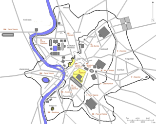
San Saba is the 21st rione of Rome, identified by the initials R. XXI. It is located within the Municipio I, and takes its name from the Basilica of San Saba, which is located there.

<span class="mw-page-title-main">Aqua Appia</span> First Roman aqueduct

The Aqua Appia was the first Roman aqueduct, constructed in 312 BC by the co-censors Gaius Plautius Venox and Appius Claudius Caecus, the same Roman censor who also built the important Via Appia.

<span class="mw-page-title-main">Porta San Sebastiano</span> Gate of the Aurelian walls, a landmark of Rome, Italy

The Porta San Sebastiano is the largest and one of the best-preserved gates passing through the Aurelian Walls in Rome (Italy).

<span class="mw-page-title-main">Tomb of the Scipios</span> Common tomb of the Scipio family during the Roman Republic

The Tomb of the Scipios, also called the hypogaeum Scipionum, was the common tomb of the patrician Scipio family during the Roman Republic for interments between the early 3rd century BC and the early 1st century AD. Then it was abandoned and within a few hundred years its location was lost.

<span class="mw-page-title-main">Via Asinaria</span> Roman road

Via Asinaria was an ancient Roman road that started from Porta Asinaria in the Aurelian walls (Rome). It was somehow connected with the Via Latina, as it is reported that Belisarius, during its advance on Rome, left the Via Latina to enter the city from Porta Asinaria; the latter was considered one of the main accesses for those coming from the south, as in ancient times the 17th-century Porta San Giovanni didn't exist.

<span class="mw-page-title-main">Piscina Publica</span>

In ancient Rome, the Piscina Publica was a public reservoir and swimming pool located in Regio XII. The region itself came to be called informally Piscina Publica from the landmark. The piscina was situated in the low-lying area between the Via Appia, the Servian Wall, and the northeast slope of the Aventine Hill, an area later occupied by the Baths of Caracalla.

<span class="mw-page-title-main">Castra Albana</span>

The Castra Albana was an ancient Roman legionary fortress of the Legio II Parthica founded by the Emperor Septimius Severus (193-211) on the site of the present Albano Laziale.

<span class="mw-page-title-main">Appian Way Regional Park</span> Large archaeological park in Rome, Italy

The Appian Way Regional Park is the second-largest urban park of Europe, after Losiny Ostrov National Park in Moscow. It is a protected area of around 4580 hectares, established by the Italian region of Latium. It falls primarily within the territory of Rome but parts also extend into the neighbouring towns of Ciampino and Marino.

<span class="mw-page-title-main">Viale Aventino</span> Street in Rome, Italy

Viale Aventino is a street that links Piazza di Porta Capena and Piazza Albania in Rome (Italy). It marks the boundary between the Rione Ripa and San Saba.

<span class="mw-page-title-main">Regio I Porta Capena</span> Historical region of Rome

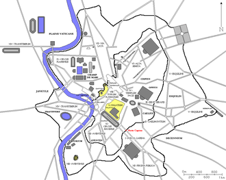
The Regio I Porta Capena is the first regio of imperial Rome, under Augustus's administrative reform. Regio I took its name from the Porta Capena, a gate of the Servian Walls, through which the Appian Way entered the city prior to the construction of the Aurelian Walls.

<span class="mw-page-title-main">Porta Viminale</span>

The Porta Viminale was a gateway in the Servian Wall of ancient Rome, at the centre of the most exposed stretch of the wall between the Porta Collina and the Porta Esquilina. These three gates and the Porta Querquetulana were the oldest in the wall.

<span class="mw-page-title-main">Museo delle Mura</span> Archaeological museum in Rome, Italy

The Museo delle Mura is an archaeological museum in Rome, Italy. It is housed in the first and second floors of the Porta San Sebastiano at the beginning of the Appian Way. It provides an exhibition on the walls of Rome and their building techniques, as well as the opportunity to walk along the inside of one of the best-preserved stretches of the Aurelian Wall. The museum is free of charge.

<span class="mw-page-title-main">Almone</span> River in Italy

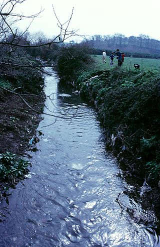
The Almone is a small river of the Ager Romanus, a few miles south of the city of Rome. Today the river is polluted and is channelled to a sewage treatment plant and no longer reaches its natural confluence with the Tiber.

<span class="mw-page-title-main">Porta Caelimontana and Porta Querquetulana</span>

Porta Caelimontana and Porta Querquetulana were two city gates that opened in the Servian Wall in Rome (Italy); only the first one is still existing.

References

  1. Becker, J. "Places: 27164982 (Porta Capena)". Pleiades. Retrieved 1 January 2024.
  2. Dionysius of Halicarnassus, Roman Antiquities, VIII, 3.
  3. Livy. Ab urbe condita . p. XXIII, 32.3.
  4. Decimus Junius Juvenalis 3.10–16.

Bibliography

41°53′02″N12°29′28″E / 41.884°N 12.491°E / 41.884; 12.491