Portezuelo | |
|---|---|
Municipality and village | |
 Portezuelo hospital | |
| Country | |
| Province | La Rioja Province |
| Time zone | UTC−3 (ART) |
Portezuelo is a municipality and village in La Rioja Province in northwestern Argentina. [1]
Portezuelo | |
|---|---|
Municipality and village | |
| Portezuelo hospital | |
| Country | |
| Province | La Rioja Province |
| Time zone | UTC−3 (ART) |
Portezuelo is a municipality and village in La Rioja Province in northwestern Argentina. [1]
This is a list of the extreme points of the United Kingdom: the points that are farther north, south, east or west than any other location. Traditionally the extent of the island of Great Britain has stretched "from Land's End to John o' Groats".
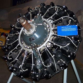
The Wright R-1820 Cyclone 9 is an American radial engine developed by Curtiss-Wright, widely used on aircraft in the 1930s through 1950s. It was produced under license in France as the Hispano-Suiza 9V or Hispano-Wright 9V, and in the Soviet Union as the Shvetsov M-25.
The Neptune Range is a mountain range, 70 nautical miles long, lying west-southwest of Forrestal Range in the central part of the Pensacola Mountains, Antarctica. The range comprises Washington Escarpment with its associated ridges, valleys and peaks, the Iroquois Plateau, the Schmidt and the Williams Hills.

Shackleton Glacier is a major Antarctic glacier, over 60 nautical miles long and from 5 to 10 nautical miles wide, descending from the Antarctic Plateau from the vicinity of Roberts Massif and flowing north through the Queen Maud Mountains to enter the Ross Ice Shelf between Mount Speed and Waldron Spurs. Discovered by the United States Antarctic Service (USAS) (1939–41) and named by the Advisory Committee on Antarctic Names (US-ACAN) for Sir Ernest Shackleton, British Antarctic explorer.

Bear Peninsula is a peninsula about 50 nautical miles long and 25 nautical miles wide which is ice-covered except for several isolated rock bluffs and outcrops along its margins, lying 3 nautical miles east of Martin Peninsula on Walgreen Coast, Marie Byrd Land, Antarctica.

The Prince Charles Mountains are a major group of mountains in Mac. Robertson Land in Antarctica, including the Athos Range, the Porthos Range, and the Aramis Range. The highest peak is Mount Menzies, with a height of 3,228 m (10,591 ft). Other prominent peaks are Mount Izabelle and Mount Stinear. These mountains, together with other scattered peaks, form an arc about 420 km (260 mi) long, extending from the vicinity of Mount Starlight in the north to Goodspeed Nunataks in the south.

The SOCATA TBM is a family of high-performance single-engine turboprop business and utility light aircraft manufactured by Daher. It was originally collaboratively developed between the American Mooney Airplane Company and French light aircraft manufacturer SOCATA.
Laguna de las Momias, also known as Laguna de los Cóndores is an archaeological site located in Leimebamba, Chachapoyas province, in the Amazonas Region of Peru, excavated by the archaeologist Federico Kauffmann Doig. The site is called Lagoon of the Condors because the people who found the lagoon would see these birds soar near the lagoon; it also obtained the name Lagoon of the Mummies because of the mummy findings around the area. The Chachapoyas were an old civilization that was located in the northern forest in the time of 900 a.c. This culture had been unknown by archaeologists for hundreds of years until the mummies appeared.

Bustarviejo is a municipality of the autonomous community of Madrid in central Spain. It belongs to the comarca of Sierra Norte.
Colquechaca is a small town in Bolivia, capital of the Province of Chayanta in the northern region of the Department of Potosí. In 2009 it has an estimated population of 1,753. It is the highest city in Bolivia, at 4,170 meters above sea level, with residences up to 4,235 meters.

Nácate is a small village in General Juan Facundo Quiroga Department Department in La Rioja Province in northwestern Argentina.
On the continent of Antarctica, the Aramis Range is the third range south in the Prince Charles Mountains, situated 11 miles southeast of the Porthos Range and extending for about 30 miles in a southwest–northeast direction. It was first visited in January 1957 by Australian National Antarctic Research Expeditions (ANARE) southern party led by W.G. Bewsher, who named it for a character in Alexandre Dumas' novel The Three Musketeers, the most popular book read on the southern journey.
Campbell Glacier is a glacier, about 60 nautical miles long, originating near the south end of Mesa Range and draining southeast between the Deep Freeze Range and Mount Melbourne to discharge into north Terra Nova Bay in Victoria Land, Antarctica.

Weir Glacier is a glacier 8 nautical miles (15 km) long, flowing north into the south part of Barilari Bay between Prestoy Point and Byaga Point, on the west coast of Graham Land. First sighted and roughly charted in 1909 by the French Antarctic Expedition under Charcot. It was surveyed in 1935-36 by the British Graham Land Expedition (BGLE) under Rymill and later named for William D. Weir, 1st Viscount Weir of Eastwood, and his son, the Hon. James K. Weir, who contributed toward the cost of the BGLE, 1934–37.

Eillium Island is a small island 2.2 km (1.4 mi) north-west of Rumbo Punta, the north-west tip of Laurie Island in the South Orkney Islands of Antarctica. It was first seen and roughly charted by Captain George Powell and Captain Nathaniel Palmer during their joint cruise in 1821. It was recharted in 1903 by the Scottish National Antarctic Expedition under Dr. William S. Bruce, who named it after his son Eillium.
Envoy Rock is a rock marking the northern limit of the Dion Islands, off the south end of Adelaide Island which is within the Argentine, British and Chilean Antarctic claims. It was charted by a Royal Navy Hydrographic Survey Unit from HMS Protector in 1963 and so named in association with Emperor Island and names from an emperor's court.

Hyde Glacier is a short glacier flowing east through the Edson Hills to join Union Glacier, in the Heritage Range, Antarctica. It was mapped by the United States Geological Survey from surveys and U.S. Navy air photos, 1961–66, and was named by the Advisory Committee on Antarctic Names for William H. Hyde, an ionospheric scientist at Little America V Station in 1958.

Hopkins Glacier is a glacier situated south of Erskine Glacier and flowing westwards into the head of Tlachene Cove in Darbel Bay on the west coast of Graham Land, Antarctica. It was photographed by Hunting Aerosurveys Ltd in 1955–57, and mapped from these photos by the Falkland Islands Dependencies Survey. It was named by the UK Antarctic Place-Names Committee in 1958 for Sir Frederick Hopkins, founder of the School of Biochemistry at Cambridge University, who made pioneer investigations on synthetic diets and vitamins which contributed greatly to the development of present ideas on concentrated rations.

The K-Index or George's Index is a measure of thunderstorm potential in meteorology. According to the National Weather Service, the index harnesses measurements such as "vertical temperature lapse rate, moisture content of the lower atmosphere, and the vertical extent of the moist layer." It was developed by the American meteorologist Joseph J. George, and published in the 1960 book Weather Forecasting for Aeronautics.
30°51′S66°42′W / 30.850°S 66.700°W
| | This article about a place in La Rioja Province, Argentina is a stub. You can help Wikipedia by expanding it. |