County Meath is a county in the Eastern and Midland Region of Ireland, within the province of Leinster. It is bordered by County Dublin to the southeast, Louth to the northeast, Kildare to the south, Offaly to the southwest, Westmeath to the west, Cavan to the northwest, and Monaghan to the north. To the east, Meath also borders the Irish Sea along a narrow strip between the rivers Boyne and Delvin, giving it the second shortest coastline of any county. Meath County Council is the local authority for the county.

County Longford is a county in Ireland. It is in the province of Leinster. It is named after the town of Longford. Longford County Council is the local authority for the county. The population of the county was 46,634 at the 2022 census. The county is based on the historic Gaelic territory of Annaly (Anghaile), formerly known as Teffia (Teathbha).
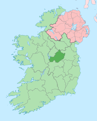
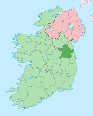
County Westmeath is a county in Ireland. It is in the province of Leinster and is part of the Eastern and Midland Region. It formed part of the historic Kingdom of Meath, which was named Mide because the kingdom was located in the geographical centre of Ireland. Westmeath County Council is the administrative body for the county, and the county town is Mullingar. At the 2022 census, the population of the county was 95,840.

County Cavan is a county in Ireland. It is in the province of Ulster and is part of the Northern and Western Region. It is named after the town of Cavan and is based on the historic Gaelic territory of East Breffny (Bréifne). Cavan County Council is the local authority for the county, which had a population of 81,704 at the 2022 census.

Mullingar is the county town of County Westmeath in Ireland. It is the third most populous town in the Midland Region, with a population of 22,667 in the 2022 census.
Dunamuggy is a townland of 172 acres in County Antrim, Northern Ireland. It is situated in the civil parish of Donegore and the historic barony of Antrim Upper.

The villages of Killucan and Rathwire are co-located in the east of County Westmeath, Ireland. As of the 2016 census, they had a combined population of 1,370. Killucan is on the R156 road about 15 km (9.3 mi) from Mullingar and 60 km (37 mi) from Dublin.
Raharney is a village in east County Westmeath, Ireland. It had a population of 221 according to the 2016 census.

Mullaghmeen, at 258 metres (846 ft), is the county top for Westmeath in Ireland, and is the lowest county top in Ireland. Mullaghmeen is located in the Mullaghmeen Forest, known for having the largest planted beech forest in Europe.

Mount Temple is a village in County Westmeath in Ireland, about 6.5 km northwest of Moate. It is noted for its golf course of the same name. It was historically called Ballyloughloe. Mount Temple and its 'sister' village, Baylin, form the only two in the parish of Ballyloughloe.

Street or Streete is a village and parish in County Westmeath, Ireland. It lies on the regional road between Lismacaffery and Rathowen. Its Irish name was historically anglicised as Straid or Strade.

Athlone Castle, sometimes known as Adamson Castle, is a castle located in Athlone, County Westmeath, Ireland, dating from the 12th century.
Portlick Castle is a late medieval tower house castle near the village of Glasson, County Westmeath, Ireland. It is located approximately 6 miles from Athlone on the shores of Lough Ree. It comprises a square late medieval 4-storey stone tower with an attached 2-storey Georgian wing and Victorian tower.

Castlelost Castle is a ruined motte-and-bailey castle located in the townland of Castlelost, just north of Rochfortbridge in County Westmeath, Ireland. The castle dates to the Norman invasion of Ireland, with some sources dating its construction to the late 12th century and associating it with Hugh Tyrrel. The castle remained within the Tyrrel family through the 16th century. During the 17th century, the castle and surrounding lands were lost by the Tyrrels during the Irish Rebellion of 1641 and subsequent Cromwellian conquest of Ireland.
Bunown is a civil parish in County Westmeath, Ireland. It is located about 38.14 kilometres (24 mi) west of Mullingar.
Wattstown is a townland in County Westmeath, Ireland. It is located about 7.64 kilometres (5 mi) north–west of Mullingar.

Baylin High Cross is a high cross and National Monument located near Athlone, County Westmeath, Ireland.
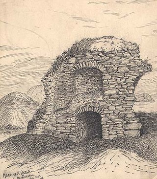
Mortimer's Castle is a castle and National Monument located in County Westmeath, Ireland.

Dunnamona is a motte-and-bailey and National Monument in County Westmeath, Ireland.
Gortlownan Motte is a motte and National Monument located in County Sligo, Ireland.
