
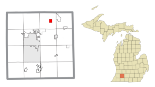
Rolland Township is a civil township of Isabella County in the U.S. state of Michigan. The population was 1,406 at the 2020 census.
Richland is a village in Kalamazoo County in the U.S. state of Michigan. The population was 751 at the 2010 census, up from 593 at the 2000 census.
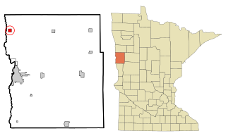
Georgetown is a city in Clay County, Minnesota, United States, along the Buffalo River near its confluence with the Red River of the North. The population was 86 at the 2020 census.
North Westminster is a census-designated place (CDP) in Windham County, Vermont, United States. The population was 262 at the 2020 census. Formerly an incorporated village, it surrendered its charter on April 20, 2010 and reverted to the town of Westminster. The village area and additional surroundings were defined by the U.S. Census Bureau as a CDP in 2012.
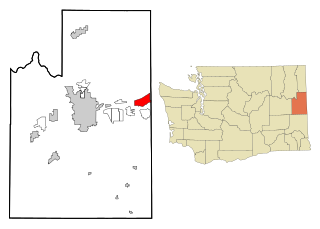
Otis Orchards-East Farms is a census-designated place (CDP) in Spokane County, Washington, United States, near the county's border with Idaho. The population was 6,299 at the 2020 census. The CDP includes the unincorporated communities of Otis Orchards and East Farms. Otis Orchards contains the bulk of the businesses of the community.

Lake Mills is a city in Jefferson County, Wisconsin, United States. The population was 6,211 at the 2020 census. The city is located partially within the Town of Lake Mills.
The extreme points of South America are the points that are farther north, south, east or west than any other location on the continent. The continent's southernmost point is often said to be Cape Horn, but Águila Islet of the Diego Ramírez Islands lies further south.

Booth Island is a Y-shaped island, 5 nautical miles long and rising to 980 metres (3,220 ft) in the northeast part of the Wilhelm Archipelago, Antarctica.

Temetiu is the South Marquesan name for the highest peak of the mountain ridge that rises above the western end of Ta'a Oa in southwestern Hiva ʻOa.

Douglas Flat is an unincorporated community in Calaveras County, California. It lies at an elevation of 1965 feet and is located at 38°06′52″N120°27′18″W. The community is in ZIP code 95229 and area code 209.

Cintruénigo is a Spanish town and municipality located in the province and autonomous community of Navarre, northern Spain. Situated in the Merindad de Tudela in the Ribera de Navarra, in the comarca of Tudela in the lower reaches of the Alhama river and 92 km from the capital of the autonomous community, Pamplona. Its population in 2020 was of 8026 according to the Instituto Nacional de Estadistica.

Asuogyaman District is one of the thirty-three districts in Eastern Region, Ghana. Originally created as an ordinary district assembly in 1988, which it was created from the former Kaoga District Council. The district assembly is located in the eastern part of Eastern Region and has Atimpoku as its capital town.
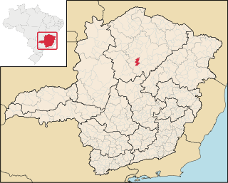
Claro dos Poções is a Brazilian municipality located in the north of the state of Minas Gerais. In 2020 the population was 7,514 in a total area of 706 km². It became a municipality in 1962.
Reynoldscroft is a community in the Canadian province of Nova Scotia, located in the Barrington Municipal District of Shelburne County.

Nova Floresta, Paraíba is a municipality in the state of Paraíba in the Northeast Region of Brazil known for its annual celebration of the stew.
Prata, Paraíba is a municipality in the state of Paraíba in the Northeast Region of Brazil.
Madang District is a district in the central part of Madang Province in Papua New Guinea. It is one of the six administrative districts that make up the province.

Kwahu Afram Plains North District is one of the thirty-three districts in Eastern Region, Ghana. Originally it was formerly part of the then-larger Kwahu North District in 1988, until the western part of the district was split off to create Kwahu Afram Plains South District on 19 June 2012; thus the remaining part has been renamed as Kwahu Afram Plains North District. The district assembly is located in the northern part of Eastern Region and has Donkorkrom as its capital town.its a food basket in the eastern region.
Katuba is a commune of the city of Lubumbashi in the Democratic Republic of the Congo.
Oto is an unincorporated community in Stone County, in the U.S. state of Missouri. The community is located on Crane Creek, approximately four miles north of Galena. Missouri Route AA passes through the community along Oto Ridge to the north of the Crane Creek crossing.
