The Ievoli Sun was a chemical tanker chartered by Napolitan ship-owner Domenico Ievoli. On 31 October 2000, she sank at 49°52′00″N02°24′00″W, approximatively 9 nautical miles off the Casquets in the English Channel, with a 6,000-tons load, including 4,000 tons of styrene, 1,000 tons of Methyl Ethyl Ketone and 1,000 tons of isopropyl alcohol.
Potha is a small village in Mansehra District of Khyber-Pakhtunkhwa province of Pakistan. It is located at 34°17'60N 73°12'0E and lies near to the city of Mansehra, the district capital. also this is the nearest village to the city of Mansehra. It has an altitude of 1113 metres and is an arid or barani area, with about 85% of the people involved in the agriculture sector. Zulfiqar Ahmad is a renown personality of village potha. Nowadays potha village is facing a problem of electricity and gas shortage due to construction of Hazara motorway (CPEC).
Tehi is a village and one of the 23 union councils of Talagang Tehsil, Chakwal District in the Punjab Province of Pakistan.

Phagwari is a village and union council of Murree Tehsil in the Rawalpindi District of Punjab, Pakistan. It is located at 33°58'60N 73°30'0E in the north-west of the tehsil, it is bounded to the north by Dewal, to the west by Rawat, to the south by Potha Sharif and to the east by Kashmir. According to the 1998 census of Pakistan it had a population of 13,060.
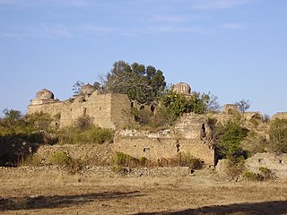
Potha Sharif is a village and union council of Murree Tehsil in the Rawalpindi District of Punjab, Pakistan. It is located in the north-east of the tehsil at 33°57'0N 73°30'0E, and is bounded to the north by Phagwari, to the south by Sehr Bagla, to the west by Rawat and to the east by Kashmir. The Potha hill has great and attractive view. The upper part of UC known as DANNA has exclusive land price and many outcasts from cities buy plots and built homes to enjoy the summer season. The village contains the mazar of the Sufi saint Hazarat Dada Malik Suraj Abbasi forefather of Potha Shareef peoples. He had seven sons and their descendants are currently present in Potha Shareef. People visit the mazar from different areas of the country to offer tribute.

Biari is a town, and one of twenty union councils in Battagram District in Khyber-Pakhtunkhwa province of Pakistan. It is located at 34°38'30N 73°24'0E and has an altitude of 1904 metres.
Kurai is a town and union council in Dera Ismail Khan District of Khyber Pakhtunkhwa. It is located at 31°52′0″N70°51′0″E and has an altitude of 164 metres.
Basti Malana is a town and union council of Dera Ghazi Khan District in the Punjab province of Pakistan. It is located at 29°52'0N 70°39'0E and has an altitude of 106 metres.
Nara is a village and union council of Jhelum District in the Punjab Province of Pakistan. It is part of Jhelum Tehsil, and is located at 32°48'0N 73°24'0E with an altitude of 236 metres (777 feet). Union council number 1 of jhelum.It has about 150 houses mostley populated by Maliks. It is about 45 kilometres from main city which is jhelum
Sanghoi is a village and union council of Jhelum District in the Punjab Province of Pakistan. It is part of Jhelum Tehsil. and is located at 32°52'0N 73°36'0E with an altitude of 223 metres (734 feet).
The Piteşti Sud Power Station is a large thermal power plant located in Piteşti, having 2 generation groups of 50 MW each and 3 groups of 12 MW having a total electricity generation capacity of 136 MW.
Achh is a village and union council of Gujrat District, in the Punjab province of Pakistan. It is part of Kharian Tehsil and is located at 32°52'0N 74°8'0E with an altitude of 311 metres.
Maruf or Maroof is a town and union council of Okara District in the Punjab province of Pakistan. It is located at 30°34'0N 73°52'0E with an altitude of 170 metres
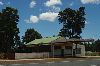
Coolup is a small town in the Peel region of Western Australia. The town is situated just off the South Western Highway and close to the Murray River. Coolup is home to the proposed new multimillion-dollar Murray Region Equestrian Centre, whose construction is in the initial stages of development.
Huta Zaborowska is a village in the administrative district of Gmina Gostynin, within Gostynin County, Masovian Voivodeship, in east-central Poland.
Bagrianwala is a town and union council of Gujrat District, in the Punjab province of Pakistan. It is part of Kharian Tehsil and is located at 32°33'0N 73°52'0E with an altitude of 217 metres.

Nawty is a village in the administrative district of Gmina Godkowo, within Elbląg County, Warmian-Masurian Voivodeship, in northern Poland. It lies approximately 31 kilometres (19 mi) east of Elbląg and 52 km (32 mi) north-west of the regional capital Olsztyn.
Dhainke is a village in the Punjab province of Pakistan.
Jamunīa or Jamania is a village in Chhatarpur District, Madhya Pradesh, India.
Bagodar is an assembly constituency in the Indian state of Jharkhand.