
The Potomac River is found within the Mid-Atlantic region of the United States and flows from the Potomac Highlands into the Chesapeake Bay. The river is approximately 405 miles (652 km) long, with a drainage area of about 14,700 square miles (38,000 km2). In terms of area, this makes the Potomac River the fourth largest river along the Atlantic coast of the United States and the 21st largest in the United States. Over 5 million people live within the Potomac watershed.

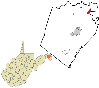
Hampshire County is a county in the U.S. state of West Virginia. As of the 2010 census, the population was 23,964. Its county seat is Romney, West Virginia's oldest town (1762). The county was created by the Virginia General Assembly in 1754, from parts of Frederick and Augusta Counties (Virginia) and is the state's oldest county. The county lies in both West Virginia's Eastern Panhandle and Potomac Highlands regions.

Woodbridge is a census-designated place (CDP) in Prince William County, Virginia, United States, located 20 miles (32 km) south of Washington, D.C. Bounded by the Occoquan and Potomac rivers, Woodbridge Magisterial District had 54,275 residents at the 2010 census. The Woodbridge census-designated place comprises just one portion of the magisterial district and had a population of 4,055 in the 2010 census. The census-designated place consists solely of the section north of Occoquan Road and Dawson Beach Road, and east of Interstate 95.

Millesons Mill is an unincorporated community hamlet in Hampshire County, West Virginia, United States. Millesons Mill is located between Springfield and Points on Springfield Pike along the South Branch Potomac River. Milleson Road meets Springfield Pike in Millesons Mill.

Opequon Creek is a 64.4-mile-long (103.6 km) tributary stream of the Potomac River. It flows into the Potomac northeast of Martinsburg in Berkeley County, West Virginia, and its source lies northwest of the community of Opequon at the foot of Great North Mountain in Frederick County, Virginia. The Opequon forms part of the boundary between Frederick and Clarke counties in Virginia and also partially forms the boundary between Berkeley and Jefferson counties in West Virginia's Eastern Panhandle.

Sleepy Creek is a 44.0-mile-long (70.8 km) tributary of the Potomac River in the United States, belonging to the Chesapeake Bay's watershed. The stream rises in Frederick County, Virginia, and flows through Morgan County, West Virginia before joining the Potomac near the community of Sleepy Creek.
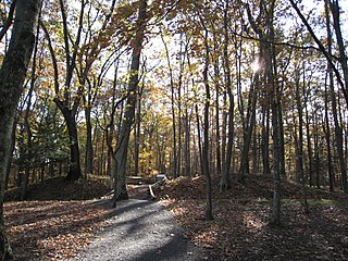
The Fort Mill Ridge Wildlife Management Area is located on 217 acres (0.88 km2) two miles (3 km) southwest of Romney in Hampshire County, West Virginia. Fort Mill Ridge WMA is owned by the West Virginia Division of Natural Resources. The Fort Mill Ridge Civil War Trenches are located at the top of the Fort Mill Ridge access road.

Four Mile Run is a 9.4-mile-long (15.1 km) stream in Northern Virginia that starts near Interstate 66, at Gordon Avenue in Fairfax County and proceeds southeast through Falls Church to Arlington County in the U.S. state of Virginia. Most of the stretch is parkland and is paralleled by two paved non-motorized transport and recreational trails, the Washington & Old Dominion Railroad Trail and the Four Mile Run Trail.

Taylorstown is a small community in Loudoun County, Virginia, built on the banks of Catoctin Creek and the surrounding hillside, about two miles (3 km) south of the Potomac River. First settled in 1734, it holds two of the oldest standing houses in Loudoun County, "Hunting Hill" and "Foxton Cottage", directly across the Catoctin Creek from each other.
Falling Waters is a census-designated place (CDP) on the Potomac River in Berkeley County, West Virginia. It is located along Williamsport Pike north of Martinsburg. According to the 2010 census, Falling Waters has a population of 876. An 1887 Scientific American article claimed that the first U.S. railroad was built in Falling Waters in 1814.
Mill Creek is a 14.5-mile-long (23.3 km) tributary of Opequon Creek, belonging to the Potomac River and Chesapeake Bay watersheds, located in Berkeley County in West Virginia's Eastern Panhandle. Its name reflects its past as a popular site for various types of mills, beginning with one constructed by Morgan Morgan in the mid-18th century near his cabin in present-day Bunker Hill.

Mill Creek is a 14.0-mile-long (22.5 km) tributary stream of the South Branch Potomac River, belonging to the Potomac River and Chesapeake Bay watersheds. The stream is located in Hampshire County in West Virginia's Eastern Panhandle. Mill Creek flows into the South Branch west of Romney Bridge near Vanderlip along the Northwestern Turnpike.

Goose Creek is a 53.9-mile-long (86.7 km) tributary of the Potomac River in Fauquier and Loudoun counties in northern Virginia. It comprises the principal drainage system for the Loudoun Valley.
Mill Creek is a 5.3-mile-long (8.5 km) tributary stream of the North Fork South Branch Potomac River in Pendleton County, West Virginia. Mill Creek rises on the western flanks of North Fork Mountain and from there, flows north through Germany Valley. Its confluence with the North Fork lies at Hinkle Gap between Germany and Harman Knobs.

Difficult Run is a 15.9-mile-long (25.6 km) tributary stream of the Potomac River in Northern Virginia in the United States. The area has had many historical uses dating back to the early 1800s. Today, the area is used recreationally by visitors interested in the watershed's variety of options including hiking, biking, fishing, boating, climbing, and bird watching. The wildlife at Difficult Run is vast as 163 different species can be seen depending on the season. There are 41 different soil types found on the trail and alongside the stream. The stream is part of the greater 57.7- square-mile Drainage basin, or watershed, located in the north-central portion of Fairfax County and drains directly to the Potomac River.

State Route 204 is a primary state highway in the U.S. state of Virginia. Known as Popes Creek Road, the state highway runs 1.73 miles (2.78 km) from SR 3 near Potomac Mills east to George Washington Birthplace National Monument in northwestern Westmoreland County.
Tacketts Mill is an unincorporated community in Stafford County, in the U.S. state of Virginia.
Mill Run is a 9.1-mile-long (14.6 km) tributary stream of the South Branch Potomac River, belonging to the Potomac River and Chesapeake Bay watersheds. The stream is located in Hampshire County in the Eastern Panhandle of the U.S. state of West Virginia. Mill Run rises on Nathaniel Mountain and flows northeast, then northwest into the South Branch south of Romney near Hampshire Park on South Branch River Road.
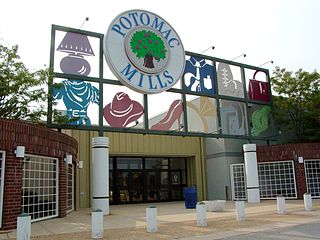
Potomac Mills is a census-designated place in Prince William County, Virginia. The population as of the 2010 Census was 5,614. It consists of the Potomac Mills mall and surrounding residential and commercial area, adjoining Dale City and Lake Ridge.