Pow-Wow Oak Tree

Last updated
The Mighty Pow-Wow Oak on Clark Road in Belvidere, January 1974 (Photo by George Koumantzelis) The MightyPowWowOakOnClarkRoadInBelvidereJanuary1974PhotoByGeorgeKoumantzelis7.JPG
The Mighty Pow-Wow Oak on Clark Road in Belvidere, January 1974 (Photo by George Koumantzelis)

The Pow-Wow Oak was an historic tree located in the Belvidere neighborhood of Lowell, Massachusetts. ("Belvidere" means "beautiful to behold" in the Italian language.) This 300-year-old tree is believed to have served as a gathering place for pow wows held by the Native American Wamesit tribe. ("Wamesit" is an Algonquian word meaning: "a cornucopia of plenty for all.") The Wamesit Indians congregated in this area for thousands of years, and the land on which this tree grew on (which was high ground with an underground spring close by) was held as sacred to them as was the tree itself. It is also said that Revolutionary War soldiers such as Deacon Thomas Clark, Captain John Trull, and General Joseph Varnum, as well as others from this New England hamlet, traveled past the Pow-Wow Oak on their way to defend Lexington and Concord on Patriots Day, April 19, 1775. This was the very beginning of the American Revolution, which started in the Commonwealth of Massachusetts.

Contents

In 1909, Middlesex County decided to pave Clark Road, then a dirt and gravel road that was referred to as "The Old Bridal Path". Albert E. O'Heir, an immigrant from Canada, who lived in the old Hunt Home at 241 Clark Road, did not want to see the tree, which stood in the middle of the road, cut down. In order that the tree might stand, O'Heir donated for one cent to the City of Lowell, 9,463 square feet of his land on Clark Road.

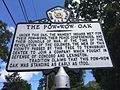
In May 1931, the Molly Varnum Chapter of the Massachusetts Daughters of the American Revolution (DAR) erected a sign next to the tree to commemorate the ancient oak, the Wamesit Indians, and the local militia who passed by it while traveling through that Lowell neighborhood (then still part of the town of Tewksbury) during the Revolutionary War. [1] [2]

Pow-Wow Oak Commemorative Sign, January 1974 (Photo by George Koumantzelis) The MightyPowWowOakOnClarkRoadInBelvidereJanuary1974PhotoByGeorgeKoumantzelis9.JPG
Pow-Wow Oak Commemorative Sign, January 1974 (Photo by George Koumantzelis)

The Pow-Wow Oak was recognized and preserved by the American Forests Historic Trees Program, [3] and by the City of Lowell via the Pow Wow Oak Tree Preservation Covenant, which was recorded on March 12, 2012, at the Middlesex (North District) Registry of Deeds, Book 25799, Page 105.

On May 21, 2013, during a very strong wind storm, a large upper branch (not the lower horizontal "arm" that pointed west) of the Pow-Wow Oak collapsed onto nearby Clark Road. [4] The following day, a decision was made by the City Manager's Office of the City of Lowell to cut down the tree to the ground because extensive interior decay in the mid to upper sections of the tree had more than partially compromised the tree and the safety of pedestrians and nearby motorists. [5]

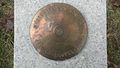
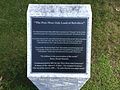
On Thursday, November 12, 2015, a dedication ceremony was held at the Peter W. Reilly Elementary School on Douglas Road in Lowell, MA, commemorating the installation of a permanent display of a huge round piece of the trunk of the Pow-Wow Oak.

See also

Related Research Articles

<span class="mw-page-title-main">Middlesex County, Massachusetts</span> County in Massachusetts, United States

Middlesex County is a county located in the Commonwealth of Massachusetts, United States. As of the 2020 census, the population was 1,632,002, making it the most populous county in both Massachusetts and New England and the 22nd most populous county in the United States. Middlesex County is one of two U.S. counties to be amongst the top 25 counties with the highest household income and the 25 most populated counties. It is included in the Census Bureau's Boston–Cambridge–Newton, MA–NH Metropolitan Statistical Area. As part of the 2020 United States census, the Commonwealth's mean center of population for that year was geo-centered in Middlesex County, in the town of Natick.

<span class="mw-page-title-main">Dracut, Massachusetts</span> Town in Massachusetts, United States

Dracut is a town in Middlesex County, Massachusetts, United States. At the 2020 census, the town's population was 32,617, making it the second most populous town in Massachusetts with an open town meeting system of governance. The town covers a total area of 21.36 square miles, 0.5 square miles of which are water.

<span class="mw-page-title-main">Lowell, Massachusetts</span> City in Massachusetts, United States

Lowell is a city in Massachusetts, United States. Alongside Cambridge, it is one of two traditional seats of Middlesex County. With an estimated population of 115,554 in 2020, it was the fifth most populous city in Massachusetts as of the last census, and the third most populous in the Boston metropolitan statistical area. The city is also part of a smaller Massachusetts statistical area, called Greater Lowell, and of New England's Merrimack Valley region.

<span class="mw-page-title-main">Tewksbury, Massachusetts</span> Town in Massachusetts, United States

Tewksbury is a town in Middlesex County, Massachusetts, United States. Its population was 31,342 as of the 2020 United States Census.

<span class="mw-page-title-main">Wilmington, Massachusetts</span> Town in Massachusetts, United States

Wilmington is a town in Middlesex County, Massachusetts, United States. Its population was 23,349 at the 2020 United States census.

<span class="mw-page-title-main">William Adams Richardson</span> American politician (1821–1896)

William Adams Richardson was an American lawyer who served as the 29th United States secretary of the treasury from 1873 to 1874. During his tenure, the Panic of 1873 swept the nation and caused a depression that lasted five years. He controversially responded by issuing $26 million in greenbacks, which averted the crisis, although there was debate as to whether he had the authority to do so. His tenure was marred by the Sanborn incident in 1874, which involved favoritism and profiteering in the collection of unpaid taxes. He was later appointed a judge, and subsequently the chief justice, of the United States Court of Claims.

<span class="mw-page-title-main">Tewksbury Hospital</span> United States historic place

Tewksbury Hospital is a National Register of Historic Places-listed site located on an 800+ acre campus in Tewksbury, Massachusetts. The centerpiece of the hospital campus is the 1894 Richard Morris Building.

<span class="mw-page-title-main">Liberty Tree</span> Elm tree in Boston, Massachusetts, US (1646–1775)

The Liberty Tree (1646–1775) was a famous elm tree that stood in Boston, Massachusetts near Boston Common in the years before the American Revolution. In 1765, Patriots in Boston staged the first act of defiance against the British government at the tree. The tree became a rallying point for the growing resistance to the rule of Britain over the American colonies, and the ground surrounding it became known as Liberty Hall. The Liberty Tree was felled in August 1775 by Loyalists led by Nathaniel Coffin Jr. or by Job Williams.

<span class="mw-page-title-main">Butler Ames</span> American politician (1871–1954)

Butler Ames was an American politician, engineer, soldier and businessman. He was the son of Adelbert Ames and grandson of Benjamin Franklin Butler, both decorated generals in the Union Army during the American Civil War.

<span class="mw-page-title-main">Massachusetts Route 38</span> State highway in Massachusetts, US

Route 38 is a state highway in the U.S. state of Massachusetts, traveling 26.5 miles (42.6 km) from Route 28 in Somerville north via Lowell to the New Hampshire state line in Dracut, where it continues as New Hampshire Route 38 in Pelham, New Hampshire. Although its southern terminus is at Route 28, some signage indicates that Route 38 continues south towards Sullivan Square in Boston.

<span class="mw-page-title-main">Highgate Wood</span> An ancient woodland in North London

Highgate Wood is a 28 hectare area of ancient woodland in North London, lying between East Finchley, Highgate and Muswell Hill. It was originally part of the ancient Forest of Middlesex which covered much of London, Hertfordshire and Essex and was mentioned in the Domesday Book. It lies in the London Borough of Haringey, but is owned and managed by the City of London Corporation.

<span class="mw-page-title-main">Tree stump</span> Remains of a tree trunk

After a tree has been cut and has fallen, the stump or tree stump is usually a small remaining portion of the trunk with the roots still in the ground. Stumps may show the age-defining rings of a tree. The study of these rings is known as dendrochronology.

The Daily Times Chronicle is a family-owned five-day daily newspaper published in Woburn, Massachusetts, with separate daily editions and associated weekly newspapers covering several towns along Massachusetts Route 128 in eastern Middlesex County.

The history of Lowell, Massachusetts, is closely tied to its location along the Pawtucket Falls of the Merrimack River, from being an important fishing ground for the Pennacook tribe to providing water power for the factories that formed the basis of the city's economy for a century. The city of Lowell was started in the 1820s as a money-making venture and social project referred to as "The Lowell Experiment", and quickly became the United States' largest textile center. However, within approximately a century, the decline and collapse of that industry in New England placed the city into a deep recession. Lowell's "rebirth", partially tied to Lowell National Historical Park, has made it a model for other former industrial towns, although the city continues to struggle with deindustrialization and suburbanization.

Barzillai Lew was an African-American soldier who served with distinction during the American Revolutionary War.

A pow wow is a gathering of Native Americans.

Capt. John Trull (1738–1797) was the commander of the Tewksbury, Massachusetts minuteman company on the first day of the American Revolution, at the Battle of Lexington & Concord.

The following is a timeline of the history of Lowell, Massachusetts, US.

<span class="mw-page-title-main">United States Cartridge Company</span> American cartridge ammunition manufacturer

The United States Cartridge Company was an early manufacturer of cartridge ammunition for small arms. The company was founded in 1869 by American Civil War general Benjamin Butler. Company startup was during the most rapid evolution of cartridge design to date. Lowell, Massachusetts emerged as one of the most successful cartridge producers in the United States while Butler served as a congressman from Massachusetts from 1867 to 1879 and as governor from 1883 to 1884. After supplying 65 percent of American small arms ammunition production for World War I, the company was acquired by the owner of Winchester Repeating Arms; and the Lowell factory closed as manufacturing shifted to New Haven, Connecticut.

<span class="mw-page-title-main">Wallace Oak (Torwood)</span>

The Wallace Oak was a tree in Torwood, Scotland. it is thought to have been part of the Torwood ancient woodland and has been linked to pre-Christian druidic worship. The tree became associated with the Scottish independence leader William Wallace. Its hollow trunk is reputed to have served him as a headquarters, hiding place and sleeping quarters. By the 17th century the tree was being used to make souvenirs due to its association with Wallace. By 1830 it was described as badly affected by the removal of timber, being reduced to a single stump. Timber being scarce above ground its roots were also dug up for souvenirs and the tree was dead by 1835.

References

  1. "Historic Spot Marked - Pow Wow Oak in Clark Road Set Apart by Members of Molly Varnum Chapter," Lowell Sun, May 30, 1931.
  2. Massachusetts Daughters of the American Revolution, Bay State News Archived 2013-10-29 at the Wayback Machine , Volume 4, Fall Issue (August 2012), page 8.
  3. "Preserving history: Pow Wow Oak Ceremony" Tewksbury Town Crier, October 8, 2012.
  4. Painful Bough for Lowell's Pow-Wow Oak, Lowell Sun, May 22, 2013
  5. Iconic Pow-Wow is felled, Lowell Sun, May 22, 2013

42°38′20″N71°16′24″W / 42.63902°N 71.27337°W / 42.63902; -71.27337