
The James River is a river in the U.S. state of Virginia that begins in the Appalachian Mountains and flows 348 miles (560 km) to Chesapeake Bay. The river length extends to 444 miles (715 km) if one includes the Jackson River, the longer of its two source tributaries. It is the longest river in Virginia and the 12th longest river in the United States that remains entirely within a single state. Jamestown and Williamsburg, Virginia’s first colonial capitals, and Richmond, Virginia's current capital, lie on the James River.
Smart Tag is the former name of a transponder-based electronic toll collection system implemented by the Virginia Department of Transportation (VDOT). It was launched as Fastoll on April 15, 1996. Fastoll was rebranded as Smart Tag in 1998, and was placed under the umbrella of Smart Travel. In November 2007, the Smart Tag brand name was retired in favor of E-ZPass Virginia, several years after the Smart Tag system became a part of the E-ZPass network.

Manchester, Virginia is a former independent city in Virginia in the United States. Prior to receiving independent status, it served as the county seat of Chesterfield County, between 1870 and 1876. Today, it is a part of the city of Richmond, Virginia.
The Robert E. Lee Memorial Bridge in Richmond, Virginia carries U.S. Route 1 and U.S. Route 301 across the James River at the Fall Line.

State Route 195 is a primary state highway in the U.S. state of Virginia. Known as the Downtown Expressway, the state highway runs 3.39 miles (5.46 km) from Interstate 195 (I-195) east to I-95 within the independent city of Richmond. SR 195 is a toll freeway that connects the West End of Richmond with Downtown Richmond. In conjunction with another toll road, SR 76, the state highway also connects the Southside suburbs of the metropolitan area with downtown. SR 195 has a mainline barrier toll plaza and ramp toll plazas at its interchanges with U.S. Route 1 and US 301 and with US 60, all of which accept E-ZPass. The state highway was constructed in the mid- to late 1970s and is maintained by the Richmond Metropolitan Authority.

State Route 76 is a state highway in the U.S. state of Virginia. Known as Powhite Parkway, the state highway runs 13.04 miles (20.99 km) from SR 652 near Midlothian north to Interstate 195 (I-195) in Richmond. SR 76 is a toll freeway that connects SR 288, U.S. Route 60, and SR 150 in Chesterfield County with I-195 and SR 195 west of Downtown Richmond. The highway includes a pair of mainline barrier toll plazas and ramp toll plazas at most interchanges, all of which accept E-ZPass. SR 76 is maintained by the Virginia Department of Transportation (VDOT) in Chesterfield County and the Richmond Metropolitan Authority in the city of Richmond. The Richmond section of the freeway was constructed in the early 1970s; the highway was extended to its current terminus in Chesterfield County in the late 1980s.

State Route 150 is a state highway in the U.S. state of Virginia. Known as Chippenham Parkway, the state highway runs 15.19 miles (24.45 km) from Interstate 95 (I-95) and SR 895 in Bensley north to Parham Road and River Road near Tuckahoe in Henrico County. SR 150 is a four- to six-lane circumferential highway that connects the Chesterfield County suburbs of Richmond with western Henrico County and, via SR 895, eastern Henrico County and Richmond International Airport. The highway is a freeway except for a short stretch east of SR 147 in Richmond. SR 150 has junctions with all of the radial highways south of the James River, including I-95, U.S. Route 1, US 301, US 360, US 60, and SR 76.
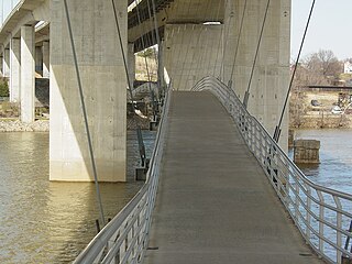
Edward E. Willey Bridge is a highway bridge which crosses the upper James River in the western portion of Henrico County, Virginia. It carries Chippenham Parkway between Parham Road in Henrico and the southwestern portion of the independent city of Richmond. It was named in honor of Edward E. Willey who was a Pharmacist and State Senator in the Virginia General Assembly from 1952 to 1983. He died in 1986.
The Richmond Metropolitan Transportation Authority is an independent authority and political subdivision which serves the Richmond, Virginia metropolitan area. Created by an act of the Virginia General Assembly in 1966, the RMTA was originally tasked with building and maintaining a toll expressway system for the Richmond area. Since then, the role of the RMTA has been expanded, and it currently owns and operates other facilities, including a number of parking decks and The Diamond, home stadium of the Richmond Braves minor league baseball team until 2008, and the current home of the Richmond Flying Squirrels. The Authority also operates historic Main Street Station on behalf of the City of Richmond.
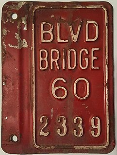
Boulevard Bridge in the independent city of Richmond, Virginia is a toll bridge which carries State Route 161 across the James River.
The Southside of Richmond is an area of the Metropolitan Statistical Area surrounding Richmond, Virginia. It generally includes all portions of the City of Richmond which lie south of the James River, and includes all of the former city of Manchester. Depending on context, the term "Southside of Richmond" can include some northern areas of adjacent Chesterfield County, Virginia in the Richmond-Petersburg region. With a minor exceptions near Bon Air, VA, the Chippenham Parkway forms the border between Chesterfield County and the City of Richmond portions of Southside, with some news agencies using the term "South Richmond" to refer to the locations in Southside located in the city proper.

Transportation in the Commonwealth of Virginia is by land, sea and air. Virginia's extensive network of highways and railroads were developed and built over a period almost 400 years, beginning almost immediately after the founding of Jamestown in 1607, and often incorporating old established trails of the Native Americans.

Transportation in Richmond, Virginia and its immediate surroundings include land, sea and air modes. This article includes the independent city and portions of the contiguous counties of Henrico and Chesterfield. While almost all of Henrico County would be considered part of the Richmond area, southern and eastern portions of Chesterfield adjoin the three smaller independent cities of Petersburg, Hopewell, and Colonial Heights, collectively commonly called the Tri-Cities area. A largely rural section of southwestern Chesterfield may be considered not a portion of either suburban area.

Westham Bridge crossed the James River between Henrico County and Chesterfield County. The bridge was located between Bosher Dam and Williams Island Dam just west of the 7 miles of rapids and falls which constitute the fall line of the James River at Richmond, Virginia.

Powhite Creek is an 8.0-mile-long (12.9 km) stream rising near the unincorporated community of Bon Air in Chesterfield County and flowing into the independent city of Richmond in central Virginia. The creek empties into the James River in the region of the Fall Line, where the rapids of the James are located upstream from the head of navigation.
Brandermill is a major suburban residential and commercial development in the Southside of Richmond, Virginia. It is located near Midlothian, Virginia at the southern terminus of the Powhite Parkway and is centered on the Swift Creek Reservoir. The Census Bureau defines it as a Census-designated place (CDP), with a population of 13,173 as of 2010.

The James River Bridge carries Interstate 95 across the James River in Richmond, Virginia.

Falling Creek was an unincorporated location in Virginia, United States, along Interstate 95 near the point where a local tributary, Falling Creek, has its confluence with the James River. It was perhaps best known as the site of one of the toll barriers on the Richmond-Petersburg Turnpike, completed in 1958. In modern times, I-95 and the more recently built Pocahontas Parkway toll road now occupy much of the site. Nearby, at the northwestern edge, the old lost town of Port Warwick was located on the river before it was destroyed during the American Revolutionary War.
Powhite Park is a 100-acre park in the city limits of Richmond, Virginia. It is close to the junction of Powhite parkway, Chippenham Parkway and Jahnke road. This park is notable for its pristinity and beaver dam, considering the park is in city limits. The park is populated by deer too. The bike trail is considered as moderate.
Stadium neighborhood or sometimes just known as Stadium is a neighborhood in the West End quadrant of Richmond, Virginia. The neighborhood encompasses City Stadium, which used to host the Richmond Spiders football program, and currently serves as the main venue for the Richmond Kickers pro soccer club.

