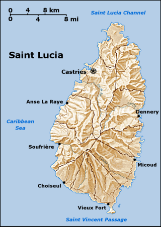
Saint Lucia is one of many small land masses composing the insular group known as the Windward Islands. Unlike large limestone areas such as Florida, Cuba, and the Yucatan Peninsula, or the Bahamas, which is a small island group composed of coral and sand, Saint Lucia is a typical Windward Island formation of volcanic rock that came into existence long after much of the region had already been formed.

Gros Islet District, one of 10 first order subdivision of the Caribbean island nation of Saint Lucia which includes the island's northernmost point, Cap Point and the notable Cap Estate, where the renowned St. Lucia Golf and Country Club is located. Whilst the town of Gros Islet is an important administrative centre, Rodney Bay is the main financial center of the district.

Dennery District is one of 10 districts of the Caribbean island nation of Saint Lucia. The seat of Dennery District is the Dennery Village. The main economic activities are fishing, and the cultivation of lima beans, bananas, and other tropical fruit. The population of the quarter was estimated at 12,876 in 2002 and fell to 12,767 in 2010.
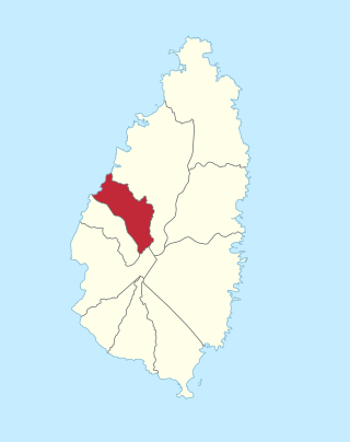
Anse la Raye District is one of 10 districts of the island nation of St. Lucia in the Caribbean Sea. The name Anse la Raye is French for cover/bay of the rays, since there are a large number of skate fish or rays in the bay. In 2005/2010, the population of the district was 6,382/6,060 people, and they are mainly fishers and agricultural workers. The main town in the area takes the same name as the district and is located down the western coast from Castries, the capital of the country.

The island nation of Saint Lucia is divided into 10 districts. The name Quarters or Quartiers originally came from the French period in Saint Lucia. The 2001 and 2010 Census of Saint Lucia refers to the first level administrative divisions as districts. The FIPS and ISO standards regularly called these divisions quarters or quartiers in French. The former district of Dauphin Quarter was merged into Gros Islet District and the former district of Praslin Quarter was merged into Micoud District.

Choiseul District is one of the 10 districts of the Caribbean island nation of Saint Lucia. Located on the southwestern side of the island, the district is home to 6,130 people, according to the 2019 census. The seat of Choiseul District is the town of Choiseul.

Micoud District is one of 10 districts of the Caribbean island nation of Saint Lucia The seat of this district is the town of Micoud inside this district. According to the 2002 census, the population of the district was 16,143 people. The final 2010 Census recorded a population of 16,284 in Micoud District. A former quarter, Praslin Quarter, was merged into Micoud Quarter. It was not enumerated separately in the 2010 Census. The 2001 Census shows Praslin as part of Micoud District.

Marigot Bay is located on the western coast of the Caribbean island country of Saint Lucia, 3.75 miles southwest from Castries and a short distance from the Saint Lucian National Marine Reserve. It is surrounded on three sides by steep, forested hills.
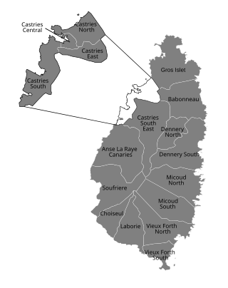
Babonneau is one of the regions of the Caribbean island nation of Saint Lucia. Babonneau is located in the north of the island in the Castries Quarter. There are extensive rain forests in the region, which is an important source of fresh water for Saint Lucia. Babonneau is also an electoral constituency of Saint Lucia represented in the House of Assembly of Saint Lucia, which extends into Gros Islet District.

Saint Lucia, an island nation in the Caribbean islands, has a relatively large tourism industry. Due to the relatively small land area of the country, most of the governmental promotion is performed by the state-operated Saint Lucia Tourism Authority, led by Executive Chairperson Agnes.
The Mabouya Valley in eastern St. Lucia in Dennery District contains two rivers, the Grande Rivière du Mabouya and the Dernière Rivière. The forested hillsides have, in places, been cleared for farming and the valley receives annual rainfall of 3000 mm (118 inches) at its head in Barre de l'Isle and 2000 mm (79 inches) at La Caye.

The Roseau Valley is a second-order subdivision in the island nation of St. Lucia. It is home to the island's largest banana plantation. The 2010 population of the Roseau Valley was 227.

Monchy is a town and second-order administrative division of Gros Islet District in the island nation of Saint Lucia. The town is located near the northern end of the island about 4 kilometres (2.5 mi) from Gros Islet, and about 7.9 kilometres (4.9 mi) from the capital, Castries.
Anse Mamin is bay on the coast with a small black sand beach in Soufrière District, Saint Lucia. It is located near Anse Chastanet and the two beaches are linked by a rocky path below the cliffs. Anse Mamin offers 12 kilometres (7.5 mi) of wooded trails.

Canaries District is one of 10 districts of the island nation of St. Lucia in the Caribbean Sea. In 2010, the population of the region was 2,009 people, and they are mainly fishers and agricultural workers. The main town in the area takes the same name as the district and is located down the western coast from Castries, the capital of the country. It is the smallest ditrict of Saint Lucia, both by population and area.
Ravine Poisson is a second-order subdivision of Saint Lucia with a population of 560 in Castries District of Saint Lucia. Ravine Poisson is also the name of a village in the Ravine Poisson subdivision. The is also a stream with the name Ravine Poisson River.
The Gamache River is a tributary of the Gulf of Saint Lawrence, flowing in the municipality of L'Île-d'Anticosti, Minganie Regional County Municipality, in the administrative region of Côte-Nord, Quebec, Canada.
The rivière Trois Milles is a tributary of Lake Saint-Georges, flowing in the municipality of L'Île-d'Anticosti, in the Minganie Regional County Municipality, in the administrative region of Côte-Nord, in province of Quebec, in Canada.

