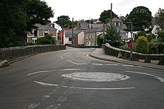
Goldsithney is a village in west Cornwall, England, United Kingdom. It is on the B3280 at grid reference SW546306, about four miles (6 km) east of Penzance and one mile (1.6 km) east of Marazion. It is in the civil parish of Perranuthnoe.

Mylor Bridge is a village in Cornwall, England, United Kingdom. It is in Mylor civil parish at the head of Mylor Creek, about five miles north of Falmouth.

Trevenson is in the parish of Carn Brea, between the towns of Camborne and Redruth in Cornwall, United Kingdom.

Crowan is a village and civil parish in Cornwall, England, United Kingdom. It is about three-and-a-half miles (6 km) south of Camborne. A former mining parish, all of the mines had shut by 1880.

St Martin-in-Meneage is a civil parish and village in the Meneage district of the Lizard Peninsula in Cornwall, England, United Kingdom.

Lesnewth is a civil parish and village in Cornwall, England, United Kingdom. It is about six miles east of Tintagel Head and two miles east of Boscastle.

Boscoppa is a settlement in the amalgamation of St Austell in Cornwall, England, United Kingdom. Originally Boscoppa was a separate village but is now a suburb of St Austell and is west of the recently built A391 bypass road. The village lies in a former mining area.

Godolphin Cross is a village in the civil parish of Breage, in west Cornwall, England. It is midway between the towns of Hayle and Helston. From 1974 until 2009 it was in Kerrier district.
Landulph is a hamlet and a rural civil parish in south-east Cornwall, England, United Kingdom. It is about 3 miles (5 km) north of Saltash in the St Germans Registration District.

The River Cober is a short river in west Cornwall, England, United Kingdom. The river runs to the west of Helston into The Loe, Cornwall's largest natural lake.

Troon is a village in Cornwall, UK, 1+1⁄2 miles southeast of Camborne. The village lies at around 560 feet (170 m) above sea level. An electoral ward named Troon and Beacon covers the area north from Troon to the outskirts of Camborne. The population at the 2011 census was 5,410.

Carlyon is one of four new civil parishes created on 1 April 2009 for the St Austell area of south Cornwall, England, United Kingdom.

Portscatho is a coastal village on the Roseland Peninsula in Cornwall, England, United Kingdom. The village adjoins Gerrans on the east side of the peninsula, about seven miles (11 km) south-southeast of Truro. It has an estimated population of 1,500 people.

Brea is a village in Cornwall, England, UK, between the towns of Camborne and Redruth. It is in the civil parish of Carn Brea and consists of Brea, Lower Brea, and Higher Brea. A small stream, the Red River, flows through the village and a hill, Carn Brea dominates the landscape to the east, along with its monument to Francis Basset.

Porkellis is a village in Cornwall, England, United Kingdom. It is approximately three and a half miles north-east of Helston, and is in the heart of the old Wendron mining district.

Carnon Downs is a village in Cornwall, England, United Kingdom. It is about three miles southwest of Truro on the A39 Truro to Falmouth road.

Kehelland is a hamlet northwest of Camborne in west Cornwall, England.
Pengegon is a residential area east of Camborne, Cornwall, England, which has a fish and chip shop, a playground and memorial to local teen Shakira Pellow. From 2013 to 2021, Pengegon was included in the Camborne Treslothan division on Cornwall Council. After boundary changes at the 2021 local elections, it was placed in the new Four Lanes, Beacon and Troon division.
Loveday Elizabeth Trevenen Jenkin is a politician, biologist and language campaigner. She has been a member of Cornwall Council since 2011, and currently serves as councillor for Crowan, Sithney and Wendron.

Crowan, Sithney and Wendron is an electoral division of Cornwall in the United Kingdom which returns one member to sit on Cornwall Council. It was created at the 2021 local elections, being formed from the former divisions of Crowan and Wendron and Breage, Germoe and Sithney. The current councillor is Loveday Jenkin, a Mebyon Kernow member.


