Last updated Car camping - Not allowed in Primitive Areas
A Primitive Area is a land designation previously used by the United States Forest Service. Although there are still lands with this title, most are now known as wilderness areas. The Forest Service began this new designation in 1929 with the L-20 regulations.[1]
The L-20 regulations defined three types of areas: Natural Area, Experimental Forest and Range, and Primitive Area. The L-20 section on Primitive Area read, "to maintain primitive conditions of transportation, subsistence, habitation, and environment to the fullest degree compatible with their highest public use." as stated by M. Rupert Cutler, in a briefing before the Subcommittee on Public Lands of the Committee on Interior and Insular Affairs, U.S. House of Representatives on July 24. 1979.
The US Forest Service, along with preservationist Bob Marshall, continued to add acreage to the fledgling wilderness system.
[Marshall's] total acreage recommendation to the Forest Service for
primitive classification was almost three times more than the Service was willing or able to set aside. Areas in which the Park Service had shown a special interest, however, were almost all formally classified as primitive areas—even those under 100,000 acres (400km2) in the West which
Stricter regulations for these new protected areas began in 1939 from Bob Marshall's efforts. This resulted in the "U-Regulations" as they came to be known. The U-Regulations superseded the L-20 Regulations and created two types of areas. Regulation U-1 created Wilderness Areas (over 100,000 acres). Regulation U-2 created Wild Areas (5,000 to 100,000 acres). The U Regulations prohibited mechanized access, timber harvesting and road construction in the wilderness and wild areas. The U-Regulations replaced the term primitive area with wilderness area and wild area and were used by the Forest Service until the passage of the federal Wilderness Act of 1964.[3]
↑ Gilligan, James P. The Development of Policy and Administration of Forest Service Primitive and Wilderness Areas in the Western United States Ph.D. dissertation,University of Michigan 1953, p. 199 Note:Taken from Gerard, David p. 20 PDF, "The Origins of the Federal Wilderness System" Ch. 6 of an anthology by Anderson from the Hoover Institution. "Archived copy"(PDF). Archived from the original(PDF) on 2011-01-05. Retrieved 2008-07-24.{{cite web}}: CS1 maint: archived copy as title (link)
In all modern states, a portion of land is held by central or local governments. This is called public land, state land, or Crown land. The system of tenure of public land, and the terminology used, varies between countries. The following examples illustrate some of the range.
Olympic National Forest is a U.S. National Forest located in Washington, USA. With an area of 628,115 acres (2,541.89 km2), it nearly surrounds Olympic National Park and the Olympic Mountain range. Olympic National Forest contains parts of Clallam, Grays Harbor, Jefferson, and Mason counties. The landscape of the national forest varies, from the temperate Olympic rain forest to the salt water fjord of Hood Canal to the peaks of Mt. Washington.
The Alaska National Interest Lands Conservation Act (ANILCA) is a United States federal law signed by President Jimmy Carter on December 2, 1980. ANILCA provided varying degrees of special protection to over 157,000,000 acres (64,000,000 ha) of land, including national parks, national wildlife refuges, national monuments, wild and scenic rivers, recreational areas, national forests, and conservation areas. It was, and remains to date, the single largest expansion of protected lands in history and more than doubled the size of the National Park System.
The Flathead National Forest is a national forest in the western part of the U.S. state of Montana. The forest lies primarily in Flathead County, south of Glacier National Park. The forest covers 2,404,935 acres of which about 1 million acres (4,000 km2) is designated wilderness. It is named after the Flathead Native Americans who live in the area.
The protected areas of Michigan come in an array of different types and levels of protection. Michigan has five units of the National Park Service system. There are 14 federal wilderness areas; the majority of these are also tribal-designated wildernesses. It has one of the largest state forest systems as well having four national forests. The state maintains a large state park system and there are also regional parks, and county, township and city parks. Still other parks on land and in the Great Lakes are maintained by other governmental bodies. Private protected areas also exist in the state, mainly lands owned by land conservancies.
The Mount Hood National Forest is a U.S. National Forest in the U.S. state of Oregon, located 62 miles (100 km) east of the city of Portland and the northern Willamette River valley. The Forest extends south from the Columbia River Gorge across more than 60 miles (97 km) of forested mountains, lakes and streams to the Olallie Scenic Area, a high lake basin under the slopes of Mount Jefferson. The Forest includes and is named after Mount Hood, a stratovolcano and the highest mountain in the state.
The Bob Marshall Wilderness Area is a congressionally-designated wilderness area located in Western Montana region of the United States. It is named after Bob Marshall (1901–1939), an early forester in the federal government, conservationist, and co-founder of The Wilderness Society. In the 1930s while working for the Forest Service, Marshall was largely responsible for designation of large areas to be preserved as roadless within lands administered by the Forest Service; he achieved this through promulgation of various regulations. Formally designated in 1964, the Bob Marshall Wilderness extends for 60 miles (97 km) along the Continental Divide and consists of 1,009,356 acres (4,084.72 km2).
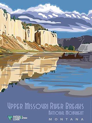
Wild Montana is a grassroots conservation organization founded by a group of Montana outfitters, ranchers, doctors, and friends. The organization is governed by a board of directors from across Montana, working at the local level through seven chapters in Helena, Bozeman, Missoula, Whitefish, Great Falls, Billings, and Butte. Each chapter is governed by a local board of directors. Since 1958, Wild Montana has worked to protect Montana's wilderness, wildlife habitat, and traditional recreation opportunities. The organization was instrumental in the passage of the 1964 Wilderness Act and in the designation of every Wilderness area in the state, like the Bob Marshall, Scapegoat, and Absaroka-Beartooth Wildernesses. It also helped win National Wild and Scenic Rivers System designations for the Missouri and Flathead rivers, and National Monument status for the Upper Missouri River Breaks.
Lassen National Forest is a United States national forest of 1,700 square miles (4,300 km2) in northeastern California. It is named after pioneer Peter Lassen, who mined, ranched and promoted the area to emigrant parties in the 1850s.
The National Wilderness Preservation System (NWPS) of the United States protects federally managed wilderness areas designated for preservation in their natural condition. Activity on formally designated wilderness areas is coordinated by the National Wilderness Preservation System. Wilderness areas are managed by four federal land management agencies: the National Park Service, the U.S. Forest Service, the U.S. Fish and Wildlife Service, and the Bureau of Land Management.
National Conservation Lands, formally known as the National Landscape Conservation System, is a 35-million-acre (140,000 km2) collection of lands in 873 federally recognized areas considered to be the crown jewels of the American West. These lands represent 10% of the 258 million acres (1,040,000 km2) managed by the Bureau of Land Management (BLM). The BLM is the largest federal public land manager and is responsible for over 40% of all the federal public land in the nation. The other major federal public land managers include the US Forest Service (USFS), National Park Service (NPS), and the US Fish and Wildlife Service (USFWS).
The Wilderness Society is an American non-profit land conservation organization that is dedicated to protecting natural areas and federal public lands in the United States. They advocate for the designation of federal wilderness areas and other protective designations, such as for national monuments. They support balanced uses of public lands, and advocate for federal politicians to enact various land conservation and balanced land use proposals. The Wilderness Society also engages in a number of ancillary activities, including education and outreach, and hosts one of the most valuable collections of Ansel Adams photographs at their headquarters in Washington, D.C.
The Ventana Wilderness of Los Padres National Forest is a federally designated wilderness area located in the Santa Lucia Range along the Central Coast of California. This wilderness was established in 1969 when the Ventana Wilderness Act redesignated the 55,800-acre (22,600 ha) Ventana Primitive Area as the Ventana Wilderness and added land, totalling 98,000 acres. In 1978, the Endangered American Wilderness Act added 61,000 acres, increasing the total wilderness area to about 159,000 acres. The California Wilderness Act of 1984 added about 2,750 acres. The Los Padres Condor Range and River Protection Act of 1992 created the approximately 14,500-acre (5,900 ha) Silver Peak Wilderness and added about 38,800 acres to the Ventana Wilderness in addition to designating the Big Sur River as a Wild and Scenic River. The Big Sur Wilderness and Conservation Act of 2002 expanded the wilderness for the fifth time, adding nearly 35,000 acres (14,000 ha), increasing the total acreage of the wilderness to its present size of 240,026 acres (97,135 ha).
The Rogue River–Siskiyou National Forest is a United States National Forest in the U.S. states of Oregon and California. The formerly separate Rogue River and Siskiyou National Forests were administratively combined in 2004. Now, the Rogue River–Siskiyou National Forest ranges from the crest of the Cascade Range west into the Siskiyou Mountains, covering almost 1.8 million acres (7,300 km2). Forest headquarters are located in Medford, Oregon.
Robert Marshall was an American forester, writer and wilderness activist who is best remembered as the person who spearheaded the 1935 founding of the Wilderness Society in the United States. Marshall developed a love for the outdoors as a young child. He was an avid hiker and climber who visited the Adirondack Mountains frequently during his youth, ultimately becoming one of the first Adirondack Forty-Sixers. He also traveled to the Brooks Range of the far northern Alaskan wilderness. He wrote numerous articles and books about his travels, including the bestselling 1933 book Arctic Village.
According to the California Protected Areas Database (CPAD), in the state of California, United States, there are over 14,000 inventoried protected areas administered by public agencies and non-profits. In addition, there are private conservation areas and other easements. They include almost one-third of California's scenic coastline, including coastal wetlands, estuaries, beaches, and dune systems. The California State Parks system alone has 270 units and covers 1.3 million acres (5,300 km2), with over 280 miles (450 km) of coastline, 625 miles (1,006 km) of lake and river frontage, nearly 18,000 campsites, and 3,000 miles (5,000 km) of hiking, biking, and equestrian trails.
The Caribou Wilderness is a federally designated wilderness area created by the Wilderness Act of 1964 and is part of the National Wilderness Preservation System. It is located 60 miles (97 km) east of Redding in the state of California, United States. The Caribou Wilderness comprises 20,546 acres (83.15 km2) and is adjacent to the east side of Lassen Volcanic National Park. Although the park is surrounded by Lassen National Forest, it is managed separately by the National Park Service, whereas the U.S. Forest Service manages the wilderness.
The Yolla Bolly–Middle Eel Wilderness is a federally designated wilderness area in the Yolla Bolly Range of the southern Klamath Mountains and the Inner Northern California Coast Ranges, in Northern California.
Browns Canyon National Monument is a 21,586 acres (87 km2) national monument in Chaffee County, Colorado, that was designated as such by President Barack Obama under the Antiquities Act on February 19, 2015. The site will be centered along the Arkansas River between Buena Vista and Salida. Browns Canyon is the most popular destination for whitewater rafting in the country, and is also known for its fishing and hiking. The monument will provide habitat protection for bighorn sheep, peregrine falcons, elk, and golden eagles.
Endangered American Wilderness Act is a Federal law, enacted in 1978, that established ten new designated Wilderness Areas in the National Forests of several Western states. Sponsored by Arizona Democrat Morris Udall, the law added approximately 400,000 thousand acres of wilderness in California, Utah, New Mexico, and Wyoming, to the National Wilderness Preservation System. Other sections of the law established three new Wilderness Areas in Oregon and added additional acreage to two existing areas, and ordered the creation of a committee to develop a management plan for 330,000 acres of public land along the Salmon River in Idaho known as the Gospel-Hump area.
This page is based on this Wikipedia article Text is available under the CC BY-SA 4.0 license; additional terms may apply. Images, videos and audio are available under their respective licenses.