Privolzhye (Russian : Приволжье) is the name of several rural localities in Russia:

Russian is an East Slavic language, which is official in the Russian Federation, Belarus, Kazakhstan and Kyrgyzstan, as well as being widely used throughout Eastern Europe, the Baltic states, the Caucasus and Central Asia. It was the de facto language of the Soviet Union until its dissolution on 25 December 1991. Although nearly three decades have passed since the breakup of the Soviet Union, Russian is used in official capacity or in public life in all the post-Soviet nation-states, as well as in Israel and Mongolia.
The classification system of the types of inhabited localities in Russia, the former Soviet Union, and some other post-Soviet states has certain peculiarities compared with the classification systems in other countries.
- Privolzhye, Samara Oblast, a selo in Privolzhsky District of Samara Oblast
- Privolzhye, Tver Oblast, a village in Zubtsovskoye Rural Settlement of Zubtsovsky District of Tver Oblast
- Privolzhye, Yaroslavl Oblast, a village in Lomovsky Rural Okrug of Rybinsky District of Yaroslavl Oblast

Privolzhsky District is an administrative and municipal district (raion), one of the twenty-seven in Samara Oblast, Russia. It is located in the west of the oblast. The area of the district is 1,379.3 square kilometers (532.6 sq mi). Its administrative center is the rural locality of Privolzhye. Population: 24,005 ; 24,552 (2002 Census); 23,058 (1989 Census). The population of Privolzhye accounts for 31.2% of the district's total population.
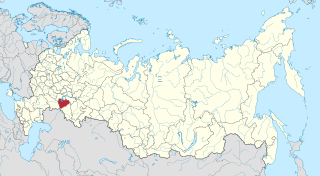
Samara Oblast is a federal subject of Russia. Its administrative center is the city of Samara. From 1935 to 1991, it was known as Kuybyshev Oblast. As of the 2010 Census, the population of the oblast was 3,215,532.

Zubtsovsky District is an administrative and municipal district (raion), one of the thirty-six in Tver Oblast, Russia. It is located in the south of the oblast and borders with Staritsky District in the north, Lotoshinsky District of Moscow Oblast in the northeast, Shakhovskoy District, also of Moscow Oblast, in the east, Gagarinsky District of Smolensk Oblast in the south, Sychyovsky District, also of Smolensk Oblast, in the southwest, and with Rzhevsky District in the west. The area of the district is 2,166.5 square kilometers (836.5 sq mi). Its administrative center is the town of Zubtsov. Population: 17,216 ; 19,398 (2002 Census); 21,950 (1989 Census). The population of Zubtsov accounts for 40.2% of the district's total population.
| This article includes a list of related items that share the same name (or similar names). If an internal link incorrectly led you here, you may wish to change the link to point directly to the intended article. |