Freetown is a town in Bristol County, Massachusetts, United States. The population was 9,206 at the 2020 census.

Lakeville is a town in Plymouth County, Massachusetts, United States. The population was 11,523 at the 2020 census.

Plymouth is a town and county seat of Plymouth County, Massachusetts, United States. Located in Greater Boston, the town holds a place of great prominence in American history, folklore, and culture, and is known as "America's Hometown". Plymouth was the site of the colony founded in 1620 by the Mayflower Pilgrims, where New England was first established. It is the oldest municipality in New England and one of the oldest in the United States. The town has served as the location of several prominent events, one of the more notable being the First Thanksgiving feast. Plymouth served as the capital of Plymouth Colony from its founding in 1620 until the colony's merger with the Massachusetts Bay Colony in 1691. The English explorer John Smith named the area Plymouth and the region 'New England' during his voyage of 1614. It was a later coincidence that, after an aborted attempt to make the 1620 trans-Atlantic crossing from Southampton, the Mayflower finally set sail for America from Plymouth, England.

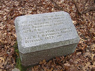
Metacomet, also known as Pometacom, Metacom, and by his adopted English name King Philip, was sachem to the Wampanoag people and the second son of the sachem Massasoit. His older brother Wamsutta briefly became sachem after their father's death in 1661. However, Wamsutta also died shortly thereafter and Metacom became sachem in 1662.
The Wampanoag, also rendered Wôpanâak, are a Native American people of the Northeastern Woodlands currently based in southeastern Massachusetts and formerly parts of eastern Rhode Island. Their historical territory includes the islands of Martha's Vineyard and Nantucket.

Massasoit Sachem or Ousamequin was the sachem or leader of the Wampanoag confederacy. Massasoit means Great Sachem. Although Massasoit was only his title, English colonists mistook it as his name and it stuck.

The Pokanoket are a group of Wampanoag people and the village governed by Massasoit, chief sachem of the Wampanoag people.
Assonet is one of two villages in the town of Freetown in Bristol County, Massachusetts, United States. An original part of the town, Assonet was settled in 1659 along with the city of Fall River, then a part of Freetown. It rests on the banks of the Assonet River. As of the 2000 census, the village had a total population of 4,084; up from 3,614 in 1990. As of the 2014 census, the village had a total estimated population of 9,093.
Stall Hill Island is a small forested inland island on Lake Rico within Massasoit State Park in Taunton, Massachusetts, United States.

Weetamoo, also referred to as Weethao, Weetamoe, Wattimore, Namumpum, and Tatapanunum, was a Pocasset Wampanoag Native American Chief. She was the sunksqua, or female sachem, of Pocasset tribe, which occupied contemporary Tiverton, Rhode Island in 1620. The Pocasset, which she led, was one of groups of the Wampanoag.
The Hockomock Swamp is a vast wetland encompassing much of the northern part of southeastern Massachusetts. This 16,950-acre (6,859 ha) land is considered the largest freshwater swamp in the state. It acts as a natural flood control mechanism for the region.

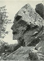
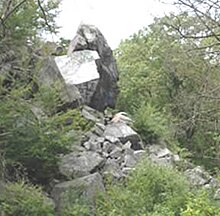
The Freetown-Fall River State Forest is a publicly owned forest covering more than 5,000 acres (2,000 ha) in the city of Fall River and the towns of Freetown and Lakeville in the state of Massachusetts. The forest lies mostly in the center of the town of Freetown dividing Assonet, East Freetown, and Fall River's northernmost boundary. The forest land includes Profile Rock, a granite outcropping which local Native Americans believe to be the image of Chief Massasoit, and a 227-acre (92 ha) Wampanoag reservation. The forest is owned by the Commonwealth of Massachusetts and operated by the Department of Conservation and Recreation with headquarters in Assonet.

The Bridgewater Triangle is an area of about 200 square miles (520 km2) within southeastern Massachusetts in the United States, claimed to be a site of alleged paranormal phenomena, ranging from UFOs to poltergeists, and other spectral phenomena, various bigfoot-like sightings, giant snakes and thunderbirds. The term was coined by New England based cryptozoologist Loren Coleman.
Mount Hope is a small hill in Bristol, Rhode Island overlooking the part of Narragansett Bay known as Mount Hope Bay. It is the highest point in Bristol County, RI. The 7000 acres that now make up the Town of Bristol in Rhode Island were called the Mt. Hope Lands. The elevation of Mt. Hope summit is 209 feet, and drops sharply to the bay on its eastern side. Mount Hope was the site of a Wampanoag (Pokanoket) village. It is remembered for its role in King Philip's War.

Fort Revere Park is a state-owned historic site and public recreation area situated on a small peninsula in the town of Hull, Massachusetts. The park occupies 6 acres (2.4 ha) on Telegraph Hill in Hull Village and houses the remains of two seacoast fortifications, including former Fort Revere.

Cole's Hill is a National Historic Landmark containing the first cemetery used by the Mayflower Pilgrims in Plymouth, Massachusetts in 1620. The hill is located on Carver Street near the foot of Leyden Street and across the street from Plymouth Rock. Owned since 1820 by the preservationist Pilgrim Society, it is now a public park.

Sachem Rock Farm is a historic farm at 355 Plymouth Street in East Bridgewater, Massachusetts, United States. The farm location is important for a variety of reasons. Its earliest historical association is with the Wampanoag people, who are known to have used the area, particularly around Sachem Rock, a granite outcrop they called Wonnocoote (Wonnocooto) that is the property's high point, prior to European contact. Sachem Rock itself is historically significant as the site of a meeting in 1649 between English settlers from the Plymouth Colony, including Myles Standish, with the Wampanoag sachem Massasoit. In this meeting the colonists purchased rights to a large tract of land, including East and West Bridgewater, Bridgewater, and Brockton.

The Patuxet were a Native American band of the Wampanoag tribal confederation. They lived primarily in and around modern-day Plymouth, Massachusetts, and were among the first Native Americans encountered by European settlers in the region in the early 17th century. Most of the population subsequently died of epidemic infectious diseases. The last of the Patuxet – an individual named Tisquantum, who played an important role in the survival of the Pilgrim colony at Plymouth – died in 1622.
The Seaconke Wampanoag Tribe is one of several cultural heritage organizations of individuals who identify as descendants of the Wampanoag people in Rhode Island and Massachusetts. Multiple nonprofit organizations were formed to represent the Seaconke Wampanoag.

The Wampanoag Tribe of Gay Head (Aquinnah) (Wampanoag: Âhqunah Wôpanâak) is a federally recognized tribe of Wampanoag people based in the town of Aquinnah on the southwest tip of Martha's Vineyard in Massachusetts, United States. The tribe hosts an annual Cranberry Day celebration.