
The British Virgin Islands (BVI), officially the Virgin Islands, are a British Overseas Territory in the Caribbean, to the east of Puerto Rico and the US Virgin Islands and north-west of Anguilla. The islands are geographically part of the Virgin Islands archipelago and are located in the Leeward Islands of the Lesser Antilles and part of the West Indies.

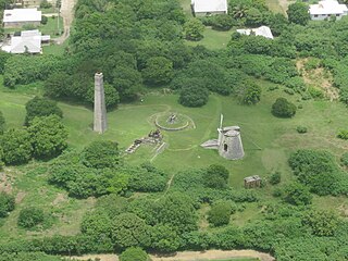
Mount Healthy windmill is a ruined windmill on the north side of Tortola in the British Virgin Islands. It was formerly used during the plantation era of the Territory to crush sugar cane. After the collapse of the sugar economy in the early nineteenth century the windmill fell into disuse and became a ruin. It crushed cane for the sugar mill and rum distillery in nearby Brewer's Bay. There are other ruins like the Boiling House, remnants of the Animal Mill Round, distillery, hospital, storage, shed, and housing. The 18th century windmill belonged to the area's wealthiest planter. Slaves harvested and processed sugar cane into sugar at this extensive sugarcane plantation.
Six Points is an unincorporated community in Washington Township, Hendricks County, Indiana. Its name refers to the junction of two streets and a railroad.
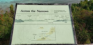
Leinster Bay is a bay and former sugar cane plantation on the island of Saint John in the United States Virgin Islands. It is uninhabited and part of Virgin Islands National Park. Visitors can park at Annaberg and hike the Leinster Bay trail to access the bay, which is a popular snorkeling spot. Waterlemon Cay is a small cay in Leinster Bay. The ruins of the plantation's estate house can be reached by continuing past the bay and up the Johnny Horn Trail.
Mary Point is an uninhabited peninsula on the island of Saint John in the United States Virgin Islands. There are no roads or trails and steep cliffs prevent access from the water. Although Mary Point once housed a small sugar cane plantation, the area is now overgrown with thick forest. The foundation and crumbling walls of Mary Point Estate can be seen from the Francis Bay trail. It is part of Virgin Islands National Park. Mary Creek, the shallow bay on the east side, is a popular spot for fly fishing and kitesurfing.
Cane is a settlement on the island of Saint Croix in the United States Virgin Islands.
Cane Valley is a settlement on the island of Saint Croix in the United States Virgin Islands.
Grove Place is a settlement on the island of Saint Croix in the United States Virgin Islands. It was added to the National Register of Historic Places in 1978.
Hogensborg is a settlement on the island of Saint Croix in the United States Virgin Islands.
Jealousy is a settlement on the island of Saint Croix in the United States Virgin Islands.

La Grange is a settlement on the island of Saint Croix in the United States Virgin Islands.
La Reine is a settlement on the island of Saint Croix in the United States Virgin Islands.
Libanon Hill is a settlement on the island of Saint Croix in the United States Virgin Islands.
Morningstar is a settlement on the island of Saint Croix in the United States Virgin Islands.
Peters Rest is a settlement on the island of Saint Croix in the United States Virgin Islands. The settlement originally formed around a sugar plantation.
Sion Hill is a settlement on the island of Saint Croix, in the United States Virgin Islands.
Upper Love is a settlement on the island of Saint Croix in the United States Virgin Islands.
Waldberggaard is a settlement on the island of Saint Croix in the United States Virgin Islands.
Whim is a settlement on the island of Saint Croix in the United States Virgin Islands.

U.S. Virgin Islands Governor's Mansion may refer to any one of the three official residences owned by the government of the U.S. Virgin Islands and provided to the Governor of the United States Virgin Islands. One residence is located on each of the three largest inhabited islands of this U.S. territory in the Caribbean. The U.S. Virgin Islands maintains more official gubernatorial residences than any other state or territory of the United States.

