Related Research Articles

Alberta is one of the thirteen provinces and territories of Canada. It is part of Western Canada and is one of the three prairie provinces. Alberta is bordered by British Columbia to the west, Saskatchewan to the east, the Northwest Territories (NWT) to the north, and the U.S. state of Montana to the south. It is one of the only two landlocked provinces in Canada. The eastern part of the province is occupied by the Great Plains, while the western part borders the Rocky Mountains. The province has a predominantly continental climate but experiences quick temperature changes due to air aridity. Seasonal temperature swings are less pronounced in western Alberta due to occasional Chinook winds.

Saskatchewan is a province in western Canada, bordered on the west by Alberta, on the north by the Northwest Territories, on the east by Manitoba, to the northeast by Nunavut, and on the south by the U.S. states of Montana and North Dakota. Saskatchewan and Alberta are the only landlocked provinces of Canada. In 2022, Saskatchewan's population was estimated at 1,205,119. Nearly 10% of Saskatchewan’s total area of 651,900 square kilometres (251,700 sq mi) is fresh water, mostly rivers, reservoirs and lakes.
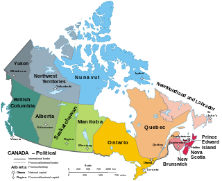
Within the geographical areas of Canada, the ten provinces and three territories are sub-national administrative divisions under the jurisdiction of the Canadian Constitution. In the 1867 Canadian Confederation, three provinces of British North America—New Brunswick, Nova Scotia, and the Province of Canada —united to form a federation, becoming a fully independent country over the next century. Over its history, Canada's international borders have changed several times as it has added territories and provinces, making it the world's second-largest country by area.
Canadian federalism involves the current nature and historical development of the federal system in Canada.

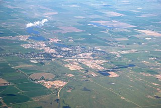
Lloydminster is a city in Canada which has the unusual geographic distinction of straddling the provincial border between Alberta and Saskatchewan. The city is incorporated by both provinces as a single city with a single municipal administration.

Crown land, also known as royal domain, is a territorial area belonging to the monarch, who personifies the Crown. It is the equivalent of an entailed estate and passes with the monarchy, being inseparable from it. Today, in Commonwealth realms such as Canada and Australia, crown land is considered public land and is apart from the monarch's private estate.
Taxation in Canada is a prerogative shared between the federal government and the various provincial and territorial legislatures.

Rangelands are grasslands, shrublands, woodlands, wetlands, and deserts that are grazed by domestic livestock or wild animals. Types of rangelands include tallgrass and shortgrass prairies, desert grasslands and shrublands, woodlands, savannas, chaparrals, steppes, and tundras. Rangelands do not include forests lacking grazable understory vegetation, barren desert, farmland, or land covered by solid rock, concrete and/or glaciers.
Brooks is a city in southeast Alberta, Canada that is surrounded by the County of Newell. It is located on Highway 1 and the Canadian Pacific Railway, approximately 186 km (116 mi) southeast of Calgary, and 110 km (68 mi) northwest of Medicine Hat. The city has an elevation of 760 m (2,490 ft).

Lac La Biche is a hamlet in Lac La Biche County within northeast Alberta, Canada. It is located approximately 220 km (140 mi) northeast of the provincial capital of Edmonton. Previously incorporated as a town, Lac La Biche amalgamated with Lakeland County to form Lac La Biche County on August 1, 2007.
The Ministry of Energy is a Cabinet-level agency of the government of the Canadian province of Alberta responsible for coordinating policy relating to the development of mineral and energy resources. It is also responsible for assessing and collecting non-renewable resource (NRR) royalties, freehold mineral taxes, rentals, and bonuses. The Alberta Petroleum Marketing Commission, which is fully integrated with the Department of Energy within the ministry, and fully funded by the Crown, accepts delivery of the Crown's royalty share of conventional crude oil and sells it at the current market value. The current ministry was formed in 1986, but ministries with other names dealing with energy resources go back to the Ministry of Lands and Mines in 1930.

The monarchy of Canada forms the core of each Canadian provincial jurisdiction's Westminster-style parliamentary democracy, being the foundation of the executive, legislative, and judicial branches of government in each province. The monarchy has been headed since September 8, 2022 by King Charles III who as sovereign is shared equally with both the Commonwealth realms and the Canadian federal entity. He, his consort, and other members of the Canadian royal family undertake various public and private functions across the country. He is the only member of the royal family with any constitutional role.
Crown corporations in Canada are government organizations with a mixture of commercial and public-policy objectives. They are directly and wholly owned by the Crown.
Land ownership in Canada is held by governments, Indigenous groups, corporations, and individuals. Canada is the second-largest country in the world by area; at 9,093,507 km² or 3,511,085 mi² of land it occupies more than 6% of the Earth's surface. Since Canada uses primarily English-derived common law, the holders of the land actually have land tenure rather than absolute ownership. The Crown is given permission to hold land by treaty granted by the Indigenous people of Canada.
Little Buffalo is an Indian settlement and hamlet in northern Alberta, Canada within Northern Sunrise County. It is located on Highway 986, approximately 100 kilometres (62 mi) northeast of the Town of Peace River and 47 kilometres (29 mi) west of Highway 88. Little Buffalo Lake is to the south of the community.
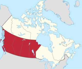
Western Canada, also referred to as the Western provinces, Canadian West or the Western provinces of Canada, and commonly known within Canada as the West, is a Canadian region that includes the four western provinces just north of the Canada–United States border namely British Columbia, Alberta, Saskatchewan and Manitoba. The people of the region are often referred to as "Western Canadians" or "Westerners", and though diverse from province to province are largely seen as being collectively distinct from other Canadians along cultural, linguistic, socioeconomic, geographic, and political lines. They account for approximately 32% of Canada's total population.

The Canadian forestry industry is a major contributor to the Canadian economy. With 39% of Canada's land acreage covered by forests, the country contains 9% of the world's forested land. The forests are made up primarily of spruce, poplar and pine. The Canadian forestry industry is composed of three main sectors: solid wood manufacturing, pulp and paper and logging. Forests, as well as forestry are managed by The Department of Natural Resources Canada and the Canadian Forest Service, in cooperation with several organizations which represent government groups, officials, policy experts, and numerous other stakeholders. Extensive deforestation by European settlers during the 18th and 19th centuries has been halted by more modern policies. Today, less than 1% of Canada's forests are affected by logging each year. Canada is the 2nd largest exporter of wood products, and produces 12.3% of the global market share. Economic concerns related to forestry include greenhouse gas emissions, biotechnology, biological diversity, and infestation by pests such as the mountain pine beetle.
The Rocky Mountains Forest Reserve is a tract of land owned by the government of Canadian province of Alberta along the eastern slopes and foothills of the Albertan section of the Canadian Rockies. It is a long strip of land just east of the more famous Canadian Rocky Mountain parks, which is managed for industrial and economic goals, rather than aesthetic and conservation goals as in the parks.
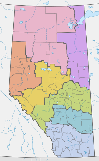
Land-use framework regions are a scheme of organizing local governments adopted by the Canadian province of Alberta. Numbering seven in total, each land-use region is named for, and roughly follows the boundary of, a major watershed. Managed by Alberta Environment and Parks, the stated aims of the program are to create a venue for regionwide planning and cooperation, promoting sustainable use of public and private lands. Every region is intended to develop and enact its own comprehensive regional land-use plan, guiding future development within its territory. However, as of 2019, approved plans have only been submitted from two of the seven regions.
References
- ↑ State of Canada's Forests 2004-2005. p. 49.
- ↑ "Green / White Areas". Archived from the original on March 12, 2009. Retrieved April 2, 2014.
- ↑ Minister of Agriculture and Lands; Crown Land Fact Sheet. Archived 2011-09-03 at the Wayback Machine
- ↑ V.P. NEIMANIS. "Crown Land". The Canadian Encyclopedia: Geography. Historica Foundation of Canada. Archived from the original on 2010-12-03. Retrieved 2007-02-12.
- ↑ Mitchell, Simon J. (June 2003), Who Owns Crown Lands?, Falls Brook Centre