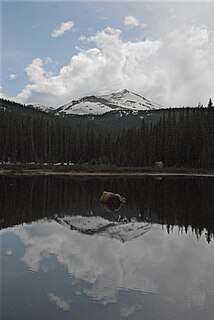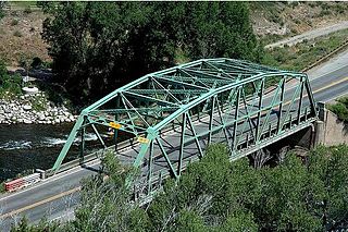
Vail Pass is a 10,662-foot-high (3,250 m) mountain pass in the Rocky Mountains of central Colorado. The pass was named for Charles Vail, a highway engineer and director of the Colorado State Highway Department from 1930 to 1945.

Beaver Creek is an unincorporated community in Eagle County, Colorado, United States. Beaver Creek is located immediately south of the town of Avon and encompasses the Beaver Creek Resort and adjacent business, lodging, and residential areas. The U.S. Post Office at Avon serves Beaver Creek postal addresses.
Beaver Lake Trail is in the northwestern Sawatch Range, part of the Rocky Mountains in the U.S. state of Colorado. It is located in the Holy Cross Wilderness north of Grouse Mountain in Eagle County. Beaver Lake Trail is south of Interstate 70, near Avon and Edwards. Beaver Lake Trail is located at the northern edge of Holy Cross Wilderness Area, west of Grouse Mountain. The Beaver Lake Trail passes south up the valley of Beaver Creek to its destination, Beaver Lake. Beaver Lake lies a short distance past the boundary of Beaver Creek Resort, west of Vail Ski Resort. Beaver Lake Trail reaches Beaver Lake after 4.4 miles of ascent and continues to Turquoise Lakes and Grouse Mountain. Hiking Colorado: Holy Cross Wilderness, a hiking guide by Kim Fenske, provides a description of Beaver Lake Trail.

Grouse Lake Trail is in the northern Sawatch Range, part of the Rocky Mountains in the U.S. state of Colorado. It is located in the Holy Cross Wilderness east of Grouse Mountain in Eagle County, south of Interstate 70, near Minturn, west of Vail and east of Avon, Colorado. It is located at the northeastern edge of Holy Cross Wilderness Area, east of Grouse Mountain.
West Grouse Creek Trail is in the northern Sawatch Range, part of the Rocky Mountains in the U.S. state of Colorado. It is located in the Holy Cross Wilderness east of Grouse Mountain and south of Beaver Creek Resort in Eagle County. West Grouse Creek Trail is south of Interstate 70, near Minturn, west of Vail and east of Avon, Colorado. West Grouse Creek Trailhead, elevation 7,880 feet, is about a half-mile north of Minturn, six miles west of Vail. West Grouse Creek Trail ascends four miles before meeting a junction with the short Olsen Lake Trail, at 11,200 feet. The trail continues winding southwest through a dense forest of spruce and fir trees to a tundra basin below the summit of Grouse Mountain. The Grouse Mountain Trail merges with the West Grouse Creek Trail, at 11,500 feet elevation, in the tundra meadow. Grouse Mountain Trail continues southwest to Grouse Mountain Pass, six miles from the trailhead, at 12,000 feet. Following the Grouse Mountain Trail southeast leads to the Martin Creek Trail and Cross Creek Trail, north of Mount of the Holy Cross. Hiking Colorado: Holy Cross Wilderness, a hiking guide by Kim Fenske, provides a description of West Grouse Creek Trail.
Notch Mountain Trail is in the northern Sawatch Range, part of the Rocky Mountains in the U.S. state of Colorado. It is located in the Holy Cross Wilderness east of Mount of the Holy Cross in Eagle County. Notch Mountain Trail is south of Interstate 70, south of Minturn, southwest of Vail and south of Beaver Creek Resort, Colorado. Notch Mountain Trail is accessible from Tigiwon Road, south of Minturn. From Fall Creek Trailhead, the hike to the summit of Notch Mountain, 13,237 feet, and back to Half Moon Campground is eight miles. Notch Mountain Trail provides access to the saddle of Notch Mountain, at 13,110 feet of elevation. The ridge of Notch Mountain overlooks the Bowl of Tears, an alpine lake, and East Cross Creek. As it tumbles north, East Cross Creek intersects with the Half Moon Trail that ascends to the summit of Mount of the Holy Cross, 14,005 feet. Notch Mountain Trail is the access route followed by thousands of pilgrims during the past century seeking the blessings of the cross formed by melting snow on the northern face of Mount of the Holy Cross. Hiking Colorado: Holy Cross Wilderness, a hiking guide by Kim Fenske, provides a description of Notch Mountain Trail.
Half Moon Pass Trail is in the northern Sawatch Range, part of the Rocky Mountains in the US state of Colorado. It is located in the Holy Cross Wilderness northeast of Mount of the Holy Cross in Eagle County. Half Moon Pass Trail is south of Interstate 70, south of Minturn, southwest of Vail and south of Beaver Creek Resort, Colorado. Half Moon Pass Trail is accessible from Tigiwon Road, south of Minturn. The hike from Half Moon Pass Trailhead, elevation 10,314 feet, to the summit of Mount of the Holy Cross and back to the trailhead is approximately twelve miles and ten hours. From Half Moon Pass, the trail descends to East Cross Creek at 10,800 feet. East Cross Creek is fed by Lake Patricia, high at 11,398 feet. Past the creek, the trail ascends rapidly above the trees into a boulder field to the top of Mount of the Holy Cross, approximately six miles from the trailhead. Hiking Colorado: Holy Cross Wilderness, a hiking guide by Kim Fenske, provides a description of Half Moon Pass Trail.
Elliot Ridge Trail is in the northern Gore Range, part of the Rocky Mountains in the U.S. state of Colorado. It is located in the Eagles Nest Wilderness, Summit County. Elliot Ridge Trail is north of Interstate 70, west of Highway 9, north of Silverthorne and near Heeney.
The Gore Range peaks provide a sharp line of delineation between Summit and Eagle Counties. The Elliot Ridge Trail slices the spine of the Gore Range and offers expansive views east to the Ptarmigan Wilderness, Summit County, and southwest to the Holy Cross Wilderness, Eagle County. Elliot Ridge Trail begins at Blue Lake, thirty-nine miles north of Silverthorne. Spring Creek Ranch Road, in Grand County, enters the White River National Forest west of Highway 9. From the highway, Elliot Ridge Trail is nearly thirteen miles up undulating gravel roads.
Buffalo Mountain Trail is in the southern Gore Range, part of the Rocky Mountains in the U.S. state of Colorado. It is located in the Eagles Nest Wilderness, Summit County. Buffalo Mountain Trail is north of Interstate 70, west of Highway 9, in Silverthorne. Buffalo Mountain Trail ascends the east ridge of Buffalo Mountain from a trailhead in Wildernest subdivision, west of Silverthorne and Dillon Reservoir.
Surprise Lake Trail is in the northern Gore Range, part of the Rocky Mountains in the U.S. state of Colorado. It is located in the Eagles Nest Wilderness, Summit County.
North Tenmile Creek Trail is in the southern Gore Range, part of the Rocky Mountains in the U.S. state of Colorado. It is located in the Eagles Nest Wilderness, Dillon Ranger District, White River National Forest, Summit County. North Tenmile Creek Trail is north of Interstate 70, in Frisco.
Gore Creek Trail is in the southern Gore Range, part of the Rocky Mountains in the U.S. state of Colorado. It is located in the Eagles Nest Wilderness, Holy Cross Ranger District, White River National Forest, Summit County. Gore Creek Trail is north of Interstate 70 in Vail.
Deluge Lake Trail is in the southern Gore Range, part of the Rocky Mountains in the U.S. state of Colorado. It is located in the Eagles Nest Wilderness, Holy Cross Ranger District, White River National Forest, Summit County. Deluge Lake Trail is north of Interstate 70 in Vail.
Booth Creek Trail is in the southern Gore Range, part of the Rocky Mountains in the U.S. state of Colorado. It is located in the Eagles Nest Wilderness, Holy Cross Ranger District, White River National Forest, Eagle County. Booth Creek Trail is north of Interstate 70 in Vail.
Booth Creek Trail ascends six miles and 3,000 feet from East Vail, at 8,400
feet, to Booth Lake, elevation 11,480 feet. Along the way, there are dozens of cataracts and small waterfalls as well as a major waterfall dropping sixty feet over a ledge.
Scarlet paintbrush, Castilleja miniata, meaning red colored, grows in meadows at the side of the trail. The sturdy spikes hold bracts of double-lobed flowers ranging in color from purple to sunset pink. Paintbrush is hemiparasitic, drawing nutrients from the roots of adjacent plants.
Pitkin Creek Trail is in the southern Gore Range, part of the Rocky Mountains in the U.S. state of Colorado. It is located in the Eagles Nest Wilderness, Holy Cross Ranger District, White River National Forest, Eagle County. Pitkin Creek Trail is north of Interstate 70 in Vail.
The Gore Range extends from Grand County in the north to Summit County and Eagle County
in the south, with many watersheds divided by steep and rugged mountain ridges. Near the middle of the western slope of the Gore Range is the Pitkin Creek Valley.
Upper Piney Lake Trail is in the northern Gore Range, part of the Rocky Mountains in the U.S. state of Colorado. It is located in the Eagles Nest Wilderness, Holy Cross Ranger District, White River National Forest, Eagle County. Upper Piney Lake Trail is north of Interstate 70 in Vail.
Upper Piney Lake Trail ascends seven miles from Piney Lake, 9,342 feet, to Upper Piney Lake, two thousand feet above the trailhead. In summer, the aspen meadows along Piney River are filled with the blooms of red columbine, Aquilegia elegantula; lambstongue groundsel, Senecio integerrimus; lovage or osha, Ligusticum porteri; common harebell, Campanula rotundifolia; and wild rose, Rosa woodsii.
Fancy Creek Trail is a hiking trail in the northern Sawatch Range, part of the Rocky Mountains in the U.S. state of Colorado. It is located in the Holy Cross Wilderness, south of Mount of the Holy Cross in Eagle County. Fancy Creek Trail is south of Interstate 70, west of Highway 24, south of Minturn, southwest of Vail and south of Beaver Creek Resort, Colorado.


