
The Sea of Okhotsk is a marginal sea of the western Pacific Ocean. It is located between Russia's Kamchatka Peninsula on the east, the Kuril Islands on the southeast, Japan's island of Hokkaido on the south, the island of Sakhalin along the west, and a stretch of eastern Siberian coast along the west and north. The northeast corner is the Shelikhov Gulf. The sea is named after the Okhota river, which in turn named after the Even word окат (okat) meaning "river".

Vitus Jonassen Bering, also known as Ivan Ivanovich Bering, was a Danish cartographer and explorer in Russian service, and an officer in the Russian Navy. He is known as a leader of two Russian expeditions, namely the First Kamchatka Expedition and the Great Northern Expedition, exploring the north-eastern coast of the Asian continent and from there the western coast on the North American continent. The Bering Strait, the Bering Sea, Bering Island, the Bering Glacier, Vitus Lake and the Bering Land Bridge were all named in his honor.

Okhotsk is an urban locality and the administrative center of Okhotsky District of Khabarovsk Krai, Russia, located at the mouth of the Okhota River on the Sea of Okhotsk. Population: 4,215 (2010 Census); 5,738 (2002 Census); 9,298 (1989 Census).

Atlasov Island, known in Russian as Ostrov Atlasova (Остров Атласова), or in Japanese as Araido (阿頼度島), is the northernmost island and volcano and also the highest volcano of the Kuril islands, part of the Sakhalin Oblast in Russia. The Russian name is sometimes rendered in English as Atlasova Island. Other names for the island include Uyakhuzhach, Oyakoba and Alaid, the name of the volcano on the island.
Gerasim Grigoryevich Izmaylov was a Russian navigator involved in the Russian colonization of the Americas and in the establishment of the colonies of Russian America in Alaska. He was responsible for the first detailed maps of the Aleutian Islands.

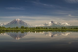
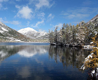
The Kamchatka Peninsula is a 1,250-kilometre-long (777 mi) peninsula in the Russian Far East, with an area of about 270,000 km2 (104,248 sq mi). The Pacific Ocean and the Sea of Okhotsk make up the peninsula's eastern and western coastlines, respectively. Immediately offshore along the Pacific coast of the peninsula runs the 10,500-metre-deep (34,449 ft) Kuril–Kamchatka Trench.

The Kuril–Kamchatka Trench or Kuril Trench is an oceanic trench in the northwest Pacific Ocean. It lies off the southeast coast of Kamchatka and parallels the Kuril Island chain to meet the Japan Trench east of Hokkaido. It extends from a triple junction with the Ulakhan Fault and the Aleutian Trench near the Commander Islands, Russia, in the northeast, to the intersection with the Japan Trench in the southwest.
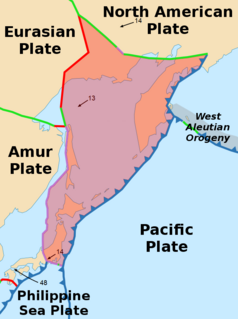
The Okhotsk Plate is a minor tectonic plate covering the Kamchatka Peninsula, Magadan Oblast, and Sakhalin Island of Russia; Hokkaido, Kantō and Tōhoku regions of Japan; the Sea of Okhotsk, as well as the disputed Kuril Islands. It was formerly considered a part of the North American Plate, but recent studies indicate that it is an independent plate, bounded on the north by the North American Plate. The boundary is a left-lateral moving transform fault, the Ulakhan Fault originating from a triple junction in the Chersky Range. On the east, the plate is bounded by the Pacific Plate at the Kuril–Kamchatka Trench and the Japan Trench, on the south by the Philippine Sea Plate at the Nankai Trough, on the west by the Eurasian Plate, and on the southwest by the Amurian Plate.
Ivan Mikhaylovich Yevreinov was a Russian geodesist and explorer.
Kamchatka Krai is a federal subject of Russia, situated in the Russian Far East, and is administratively part of the Far Eastern Federal District. Its capital and largest city is Petropavlovsk-Kamchatsky, home to over half of its population of 322,079 (2010).
Three Brothers may refer to:
The 1952 Severo-Kurilsk earthquake struck off the coast of the Kamchatka Peninsula. The 9.0 Mw earthquake triggered a major tsunami that hit Severo-Kurilsk, Kuril Islands, Sakhalin Oblast, Russian SFSR, USSR, on 4 November 1952 at 16:58 (UTC). This led to the destruction of many settlements in Sakhalin Oblast and Kamchatka Oblast, while the main impact struck the town of Severo-Kurilsk. It was the fifth most powerful earthquake since 1900, and to date, the most powerful earthquake in Russian history.
The Okhotsk Coast is an informal name for the northwest coast of the Sea of Okhotsk. Although it was never an administrative unit there is some reason to treat it as a distinct region. Here in 1639 the Russians first reached the Pacific Ocean. From here, beginning in 1716, Russian ships sailed east to the Kamchatka Peninsula, the Aleutian Islands and Alaska.
Zubchaty is an uninhabited island in Shelikhov Gulf of the northeastern Sea of Okhotsk. It lies on the eastern side of Penzhina Bay. It has a serrated summit.
Ptichy Island is a small island in the Sea of Okhotsk. It lies close to the mainland off the western coast of the Kamchatka Peninsula.

The First Kamchatka expedition was the first Russian expedition to explore the Asian Pacific coast. It was commissioned by Peter the Great in 1724 and was led by Vitus Bering. Afield from 1725 to 1731, it was Russia's first naval scientific expedition. It confirmed the presence of a strait between Asia and America and was followed in 1732 by the Second Kamchatka Expedition.
The Okhotsk-Manchurian taiga ecoregion is an area of coniferous forests in the Russian Far East, covering the Amur River delta, the west coast of the Okhotsk Sea, and the rugged extension of the northern Sikhote-Alin Mountains that run southwest-to-northeast through the Primorsky and Khabarovsk regions. It is the southernmost taiga forest in Eurasia. The ecoregion is distinguished from surrounding ecoregions by the slightly warmer climate due to the maritime influence and the shield of the mountains to the west, and by the mixing of flora and fauna species from Okhotsk-Kamchatka communities to the north and Manchurian species from the south. The forest at lower altitudes is "light taiga", and "dark taiga" at higher altitudes.
Cape Bol'shoy Dugandzha is a headland in Khabarovsk Krai, Russia.

The Kamchatka-Aleutian triple junction is a triple junction of tectonic plates of the Fault-Fault-Trench type where the Pacific Plate, the Okhotsk Plate, and the North American Plate meet. It is located east of the Kamchatka Mys peninsula and west of Bering Island. Meiji Seamount is located to the southeast of the junction.

Utichy Island is a small island in the western Sea of Okhotsk. It is one of the Shantar Islands. It lies southwest of the southwest point of Bolshoy Shantar Island and northeast of Ptichy Island.