A data set is a collection of data. In the case of tabular data, a data set corresponds to one or more database tables, where every column of a table represents a particular variable, and each row corresponds to a given record of the data set in question. The data set lists values for each of the variables, such as height and weight of an object, for each member of the data set. Each value is known as a datum. Data sets can also consist of a collection of documents or files.
In cryptography, encryption is the process of encoding a message or information in such a way that only authorized parties can access it and those who are not authorized cannot, Encryption does not itself prevent interference, but denies the intelligible content to a would-be interceptor. In an encryption scheme, the intended information or message, referred to as plaintext, is encrypted using an encryption algorithm – a cipher – generating ciphertext that can be read only if decrypted. For technical reasons, an encryption scheme usually uses a pseudo-random encryption key generated by an algorithm. It is in principle possible to decrypt the message without possessing the key, but, for a well-designed encryption scheme, considerable computational resources and skills are required. An authorized recipient can easily decrypt the message with the key provided by the originator to recipients but not to unauthorized users.
A Geographic Information System (GIS) is a system designed to capture, store, manipulate, analyze, manage, and present spatial or geographic data. GIS applications are tools that allow users to create interactive queries, analyze spatial information, edit data in maps, and present the results of all these operations. GIS sometimes refers to geographic information science (GIScience), the science underlying geographic concepts, applications, and systems. Since the mid-1980s, geographic information systems have become valuable tool used to support a variety of city and regional planning functions.

The Geographic Names Information System (GNIS) is a database that contains name and locative information about more than two million physical and cultural features located throughout the United States of America and its territories. It is a type of gazetteer. GNIS was developed by the United States Geological Survey in cooperation with the United States Board on Geographic Names (BGN) to promote the standardization of feature names.

A hotspot is a physical location where people may obtain Internet access, typically using Wi-Fi technology, via a wireless local-area network (WLAN) using a router connected to an Internet service provider.
The National Center for Education Statistics (NCES) is the part of the United States Department of Education's Institute of Education Sciences (IES) that collects, analyzes, and publishes statistics on education and public school district finance information in the United States. It also conducts international comparisons of education statistics and provides leadership in developing and promoting the use of standardized terminology and definitions for the collection of those statistics. NCES is a principal agency of the U.S. Federal Statistical System.
PubMed Central (PMC) is a free digital repository that archives publicly accessible full-text scholarly articles that have been published within the biomedical and life sciences journal literature. As one of the major research databases within the suite of resources that have been developed by the National Center for Biotechnology Information (NCBI), PubMed Central is much more than just a document repository. Submissions into PMC undergo an indexing and formatting procedure which results in enhanced metadata, medical ontology, and unique identifiers which all enrich the XML structured data for each article on deposit. Content within PMC can easily be interlinked to many other NCBI databases and accessed via Entrez search and retrieval systems, further enhancing the public's ability to freely discover, read and build upon this portfolio of biomedical knowledge.

The Twentieth United States Census, conducted by the Census Bureau, determined the resident population of the United States to be 226,545,805, an increase of 11.4 percent over the 203,184,772 persons enumerated during the 1970 Census. It was the first census in which a state – California – recorded a population of 20 million people, as well as the first in which all states recorded populations of over 400,000.
The United States Census of 1860 was the eighth Census conducted in the United States starting June 1, 1860, and lasting five months. It determined the population of the United States to be 31,443,322, in 33 states and 10 organized territories. This was an increase of 35.4 percent over the 23,191,876 persons enumerated during the 1850 Census. The total population included 3,953,762 slaves.
The United States Census of 1880 conducted by the Census Bureau during June 1880 was the tenth United States Census. It was the first time that women were permitted to be enumerators. The Superintendent of the Census was Francis Amasa Walker. This was the first census in which a city – New York – recorded a population of over one million.

The Twelfth United States Census, conducted by the Census Office on June 1, 1900, determined the resident population of the United States to be 76,212,168, an increase of 21.0 percent over the 62,979,766 persons enumerated during the 1890 Census.
The Fifteenth United States Census, conducted by the Census Bureau one month from April 1, 1930, determined the resident population of the United States to be 122,775,046, an increase of 13.7 percent over the 106,021,537 persons enumerated during the 1920 Census.
The Seventeenth United States Census, conducted by the Census Bureau, determined the resident population of the United States to be 150,697,361, an increase of 14.5 percent over the 131,669,275 persons enumerated during the 1940 Census. This was the first census in which:
The Eighteenth United States Census, conducted by the Census Bureau, determined the resident population of the United States to be 179,323,175, an increase of 18.5 percent over the 151,325,798 persons enumerated during the 1950 Census. This was the first census in which all states recorded a population of over 200,000.
The Nineteenth United States Census, conducted by the Census Bureau, determined the resident population of the United States to be 203,392,031, an increase of 13.4 percent over the 179,323,175 persons enumerated during the 1960 Census. This was the first census since 1800 in which New York was not the most populous state – California overtook it in population in November 1962. This was also the first census in which all states recorded a population of over 300,000, and the first in which a city in the geographic South recorded a population of over 1 million (Houston).
DAFIF or the Digital Aeronautical Flight Information File is a comprehensive database of up-to-date aeronautical data, including information on airports, airways, airspaces, navigation data and other facts relevant to flying in the entire world, managed by the National Geospatial-Intelligence Agency (NGA) of the United States.
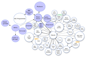
Open data is the idea that some data should be freely available to everyone to use and republish as they wish, without restrictions from copyright, patents or other mechanisms of control. The goals of the open-source data movement are similar to those of other "open(-source)" movements such as open-source software, hardware, open content, open education, open educational resources, open government, open knowledge, open access, open science, and the open web. Paradoxically, the growth of the open data movement is paralleled by a rise in intellectual property rights. The philosophy behind open data has been long established, but the term "open data" itself is recent, gaining popularity with the rise of the Internet and World Wide Web and, especially, with the launch of open-data government initiatives such as Data.gov, Data.gov.uk and Data.gov.in.
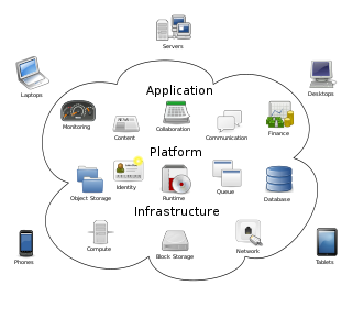
Cloud computing is the on-demand availability of computer system resources, especially data storage and computing power, without direct active management by the user. The term is generally used to describe data centers available to many users over the Internet. Large clouds, predominant today, often have functions distributed over multiple locations from central servers. If the connection to the user is relatively close, it may be designated an edge server.

Google Public Data Explorer provides public data and forecasts from a range of international organizations and academic institutions including the World Bank, OECD, Eurostat and the University of Denver. These can be displayed as line graphs, bar graphs, cross sectional plots or on maps. The product was launched on March 8, 2010 as an experimental visualization tool in Google Labs.
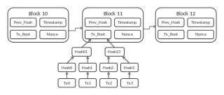
A blockchain, originally block chain, is a growing list of records, called blocks, that are linked using cryptography. Each block contains a cryptographic hash of the previous block, a timestamp, and transaction data.