
La Puente is a city in Los Angeles County, California, United States. The city had a population of 39,816 at the 2010 census and is approximately 20 miles east of downtown Los Angeles.

West Puente Valley is an unincorporated community and census-designated place in Los Angeles County, California, USA, northwest of La Puente. The population was 22,636 at the 2010 census, up from 22,589 at the 2000 census. The community is probably named for its location related to the city of La Puente.

Juan Emilio Bosch Gaviño was a Dominican politician, historian, short story writer, essayist, educator, and the first democratically elected president of the Dominican Republic for a brief time in 1963. Previously, he had been the leader of the Dominican opposition in exile to the dictatorial regime of Rafael Trujillo for over 25 years. To this day he is remembered as an honest politician and regarded as one of the most prominent writers in Dominican literature. He founded both the Dominican Revolutionary Party (PRD) in 1939 and the Dominican Liberation Party (PLD) in 1973.

Puente Nacional is a municipality in the Mexican state of Veracruz. Puente Nacional is bordered by Actopan, the port of Veracruz, and La Antigua. It stands on the railway and on Federal Highways 140 and 125. In Puente Nacional the major products are coffee, fruits, and sugar.
El puente del Papa is a bridge located in Monterrey, Nuevo León, Mexico, across the usually dry Río Santa Catarina. It took its name when Pope John Paul II offered a Catholic mass over the bridge.

Rímac is a district in the Lima Province, Peru. It lies directly to the north of downtown Lima, to which it is connected by six bridges over the Rímac River. The district also borders the Independencia, San Martín de Porres, and San Juan de Lurigancho districts. Vestiges of Lima's colonial heyday remain today in an area of the Rímac district known as the Historic centre of Lima, which was declared a UNESCO World Heritage Site in 1988. Downtown Rímac District has, like its southern counterpart, its eastern and western sides divided by Jirón Trujillo, which connects to Lima District's Jirón de la Unión through the Puente de Piedra, the oldest bridge in the whole city. Rímac's East side features the Plaza de Acho, the most famous bullfighting arena in South America and one of the most well known in the world.

Puente La Reina is a town and municipality located in the autonomous community of Navarre, in northern Spain.

Quisqueya Stadium Juan Marichal is a baseball stadium in Santo Domingo, Dominican Republic. It is often used as a multi-use stadium. Football club Atlético Pantoja used the venue for their inaugural Caribbean football championship match. The Quisqueya holds about 14,469 people after its renovation. The Dominican League of Baseball Authority is in charge of its management.
Estadio Olímpico Félix Sánchez is a multi-purpose stadium in Santo Domingo, Dominican Republic, built in 1974 for the XII Central American & Caribbean Games.
The Tito Puente Amphitheatre is a concert amphitheater in San Juan, Puerto Rico. It is named after the late mambo musician and percussionist Tito Puente. It was previously named "Luis Muñoz Marín Amphitheatre"

The Juan Pablo II Bridge, also known as Puente Nuevo, is a bridge in Chile connecting Concepción and Talcahuano with San Pedro de la Paz, through the Biobío River. Since completion in 1974 it has remained the longest bridge in the country. It was significantly damaged in the February 27, 2010 earthquake.
Monte Plata Batley Juan Sanchez Airport is located in Monte Plata, Dominican Republic. This Airport receive some charter flights from other cities in the country.

The Bridge of the Americas (BOTA) is a group of international bridges which cross the Rio Grande and Texas State Highway Loop 375, connecting the Mexico–United States border cities of Ciudad Juárez, Chihuahua and El Paso, Texas, via the MX 45 from the south and the I-110 from the north, crossing the El Paso BOTA Port of Entry. The bridge is colloquially known as "Puente Libre" in Ciudad Juárez, officially as "Puente Internacional Córdova-Las Américas" or "Puente Internacional Córdova de las Américas", and also known as "Puente Río Bravo", "Cordova Bridge" and "Free Bridge".

This portion of National Register of Historic Places listings in Puerto Rico is along the central mountain region, from Las Marías and Maricao in the central-west to Juncos in the central-east, including the slopes of the Cordillera.
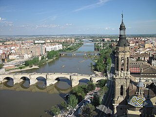
The Puente de Piedra is a bridge across the river Ebro in Zaragoza, Spain.

Atocha is a central ward (barrio) of Madrid belonging to the district of Arganzuela.

Del Otro Lado del Puente is the title of a soundtrack album released by Mexican singer-songwriter Juan Gabriel for the movie Del Otro Lado del Puente in 1979 and was re-release in 1996.

Colegio Madrid, A.C. is a private school in Col. Ex Hacienda San Juan de Dios, Tlalpan, Mexico City, serving preschool through senior high school (bachillerato). In 1941 an exile from the Spanish Civil War established the school.

The Puente de los Leones is a historic bridge in Ponce, Puerto Rico, joining Barrio Tercero to Barrio San Antón and Barrio Machuelo Abajo. It is also the city's best known bridge. The bridge is at the western terminus of Bulevar Miguel Pou, the main gateway to the Ponce Historic Zone. The Art Deco bridge carries four lanes of vehicular traffic from the two-way Miguel Pou Boulevard. It crosses Río Portugués connecting Barrio Tercero to the west with Barrios Machuelo Abajo and San Anton to the east. It is located 0.5 km east of Plaza Las Delicias.


