
The Gulf of St. Lawrence is the outlet of the North American Great Lakes via the St. Lawrence River into the Atlantic Ocean. The gulf is a semi-enclosed sea, covering an area of about 226,000 square kilometres (87,000 sq mi) and containing about 34,500 cubic kilometres (8,300 cu mi) of water, at an average depth of 152 metres (500 ft).

Adélie Land or Adélie Coast is a claimed territory of France located on the continent of Antarctica. It stretches from a portion of the Southern Ocean coastline all the way inland to the South Pole. France has administered it as one of five districts of the French Southern and Antarctic Lands since 1955 and applied the Antarctic Treaty System rules since 1961. Article 4 of the Antarctic Treaty deals with territorial claims, and although it does not renounce or diminish any preexisting claims to sovereignty, it also does not prejudice the position of contracting parties in their recognition or non-recognition of territorial sovereignty. France has had a permanent station in Adélie Land since April 9, 1950.

This is a list of the extreme points of Ireland – the points that are farthest north, south, east or west in Ireland. It includes the Republic of Ireland and Northern Ireland.
The Northumberland Islands are a scattered island chain off the eastern coast of Queensland, Australia.

Malpartida de Plasencia is a municipality located in the province of Cáceres, Extremadura, Spain. According to the 2015 census (INE), the municipality has a population of 4714 inhabitants.
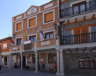
Casarrubios del Monte is a municipality located in the province of Toledo, Castile-La Mancha, Spain. According to the 2006 census (INE), the municipality has a population of 4321 inhabitants.

Quintanar de la Sierra is a municipality and town located in the province of Burgos, Castile and León, Spain. According to the 2004 census (INE), the municipality has a population of 1,896 inhabitants.

Villacarralón is a municipality located in the province of Valladolid, Castile and León, Spain. According to the 2004 census (INE), the municipality has a population of 89 inhabitants.

Joaíma is a Brazilian municipality located in the northeast of the state of Minas Gerais.
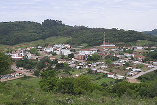
Nova Pádua is a municipality in the state of Rio Grande do Sul, Brazil. As of 2020, the estimated population was 2,558.

Chichiquila Municipality is a municipality in the Mexican state of Puebla in south-eastern Mexico.
La Bajada (San Luis) is a village and municipality in San Luis Province in central Argentina.

Comandante Fontana is an Argentinian city, located in Chaco Province in northern Argentina.

Larroque is a city in the Entre Ríos Province, in north-eastern Argentina. It is located on the South of the province, between Gualeguay and Gualeguaychú. It has a population of 6,451 according to the 2010 Census.

Apéndice Island, also known as Isla Telegrafista Rivera or Sterneck Island, is an island in Hughes Bay lying north of Renzo Point on Relyovo Peninsula and west of Sucia Point on Sladun Peninsula, Graham Land in Antarctica. The name appears on an Argentine government chart of 1957. It forms part of the Cierva Point and offshore islands Important Bird Area and ASPA 134.

Boydell Glacier is a glacier on Trinity Peninsula in northern Graham Land. It is about 9 miles (14 km) long, flowing southeastward from Detroit Plateau to enter Sjögren Inlet in Prince Gustav Channel north of the terminus of Sjögren Glacier and 6 miles (10 km) west of Mount Wild. It was mapped by the Falkland Islands Dependencies Survey from surveys (1960–61), and named by the UK Antarctic Place-Names Committee for James Boydell, English inventor of a steam traction engine, the first practical track-laying vehicle.

Caraquet Rock is a rock lying nearly 4 nautical miles (7 km) west-southwest of Bell Point, off the west part of King George Island in the South Shetland Islands. It was named by the UK Antarctic Place-Names Committee in 1960 for the sealing vessel Caraquet from Liverpool, which visited the South Shetland Islands in 1821–22.
Cumpston Glacier is a small glacier on the east coast of Graham Land, draining between Breitfuss Glacier and Quartermain Glacier into the head of Mill Inlet. It was named by the UK Antarctic Place-Names Committee for J.S. Cumpston, an Australian historian of the Antarctic.