
Kukenan Falls is the second tallest major waterfall in Venezuela after Angel Falls. It is also the second tallest free-leaping waterfall in the world. Overall, it is usually cited as the 11th highest waterfall in the world. The falls drop in a single leap of around 2,211 feet (674 m) and the final portion of the falls trickles down towards the base of the Kukenan Tepui.
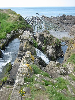
Welcombe is a village and civil parish on the coast of north Devon, England, just north of the border with Cornwall. It is part of the district of Torridge. The population taken at the 2011 census was 187.

Polentinos is a municipality located in the province of Palencia, Castile and León, Spain. According to the 2004 census (INE), the municipality has a population of 78 inhabitants.
Mount Shadow is a small peak in the Admiralty Mountains that rises above and close west of Shadow Bluff at the junction of the Tucker and Leander Glaciers. Climbed by the geological team of the New Zealand Geological Survey Antarctic Expedition (NZGSAE), 1957–58, in January 1958, and named from association with Shadow Bluff and nearby Mount Midnight.
Santiago Nacaltepec is a town and municipality in Oaxaca in south-western Mexico. The municipality covers an area of 213,06 km2. It is part of Cuicatlán District in the north of the Cañada Region.
Gaspar, Santa Catarina is a municipality in the state of Santa Catarina in the South region of Brazil.
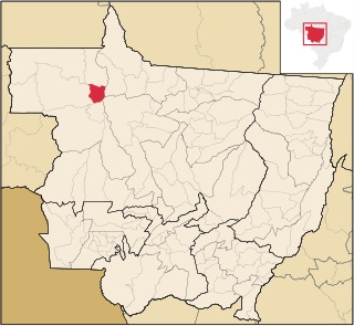
Juruena is a municipality in the state of Mato Grosso in the Central-West Region of Brazil.

Colonia Benítez is a village and municipality in Chaco Province in northern Argentina. It was one of the first towns and agricultural settlements of the province, when the cultivation of cotton and various industries were the pillars of its development with over the years.
Popgrigorovo is a village in the municipality of Dobrichka, in Dobrich Province, in northeastern Bulgaria.

Rodeillo is a village located 25 kilometers from Pichilemu, in central Chile.

Pottinger Point is a low-lying, ice-free promontory 4 km (2.5 mi) east of Round Point, about 500 m long, on the north coast of King George Island in the South Shetland Islands of Antarctica. It was named by the United Kingdom Antarctic Place-Names Committee (UK-APC) in 1960 for Captain Pottinger, Master of the Tartar from London, who visited the South Shetland Islands in 1821–22.
Goldsmith Glacier is a glacier flowing west-northwest through the Theron Mountains of Antarctica, 6 nautical miles (11 km) south of Tailend Nunatak. It was first mapped in 1956–57 by the Commonwealth Trans-Antarctic Expedition (CTAE) and named for Rainer Goldsmith, medical officer with the advance party of the CTAE in 1955–56.
The Lorn Rocks are a group of rocks lying 12 nautical miles (22 km) west of the north end of Lahille Island, in the Biscoe Islands of Antarctica. They were mapped by the Falkland Islands Dependencies Survey from photos taken by Hunting Aerosurveys Ltd in 1956–57, and were so named by the UK Antarctic Place-Names Committee because the rocks are small, forlorn and deserted.

Mount McKeown is a mountain rising to 1,880 metres (6,170 ft) on the north side of Embree Glacier, 3 nautical miles (6 km) northeast of Mount Schmid, and forming the south extremity of Sostra Heights in the northern part of the Sentinel Range, Ellsworth Mountains in Antarctica. It was first mapped by the United States Geological Survey from surveys and U.S. Navy air photos from 1957 to 1959, and was named by the Advisory Committee on Antarctic Names for First Lieutenant Donald F. McKeown of the United States Air Force who participated in establishing the South Pole Station in the 1956–57 season.
Snyder Peak is a low ice-covered peak lying 1 nautical mile (1.9 km) southwest of Anderson Dome in the Jones Mountains. It was mapped by the University of Minnesota Jones Mountains Party of 1960–61. It was named by the Advisory Committee on Antarctic Names (US-ACAN) for David R. Snyder, an aviation electronics technician with U.S. Navy Squadron VX-6, and a crew member on pioneer flights of LC-47 Dakota aircraft from Byrd Station to the Eights Coast area in November 1961.
Oulad Fares is a small town and rural commune in Settat Province of the Chaouia-Ouardigha region of Morocco. At the time of the 2004 census, the commune had a total population of 11961 people living in 1812 households.
Staritsa is the name of several inhabited localities in Russia.
Pavlov or Pavlova is the name of several rural localities in Russia.

Washfield is a village, parish and former manor in Devon, England, situated about 2 miles north-west of Tiverton. The parish church is dedicated to St Mary the Virgin. It was within the jurisdiction of the historic West Budleigh Hundred.
