Related Research Articles

Novarupta is a volcano that was formed in 1912, located on the Alaska Peninsula in Katmai National Park and Preserve, about 290 miles (470 km) southwest of Anchorage. Formed during the largest volcanic eruption of the 20th century, Novarupta released 30 times the volume of magma of the 1980 eruption of Mount St. Helens.

Mount Spurr is a stratovolcano in the Aleutian Arc of Alaska, named after United States Geological Survey geologist and explorer Josiah Edward Spurr, who led an expedition to the area in 1898. The Alaska Volcano Observatory (AVO) currently rates Mount Spurr as Level of Concern Color Code Green. The mountain is known aboriginally by the Dena'ina Athabascan name K'idazq'eni, literally 'that which is burning inside'.

Redoubt Volcano, or Mount Redoubt, is an active stratovolcano in the largely volcanic Aleutian Range of the U.S. state of Alaska. Located at the head of the Chigmit Mountains subrange in Lake Clark National Park and Preserve, the mountain is just west of Cook Inlet, in the Kenai Peninsula Borough about 110 miles (180 km) southwest of Anchorage. At 10,197 feet (3,108 m), in just over 5 miles (8 km) Mount Redoubt attains 9,150 feet (2,700 m) of prominence over its surrounding terrain. It is the highest summit in the Aleutian Range. In 1976, Redoubt Volcano was designated as a National Natural Landmark by the National Park Service.
A volcano tectonic earthquake is an earthquake caused by the movement of magma beneath the surface of the Earth. The movement results in pressure changes where the rock around the magma has experienced stress. At some point, this stress can cause the rock to break or move. This seismic activity is used by scientists to monitor volcanoes. The earthquakes may also be related to dike intrusion or occur as earthquake swarms.

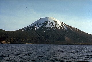
Mount Shishaldin is a moderately active volcano on Unimak Island in the Aleutian Islands chain of Alaska. It is the highest mountain peak of the Aleutian Islands. The most symmetrical cone-shaped glacier-clad large mountain on Earth, the volcano's topographic contour lines are nearly perfect circles above 6,500 feet (2,000 m). The lower north and south slopes are somewhat steeper than the lower eastern and western slopes. The volcano is the westernmost of three large stratovolcanoes along an east–west line in the eastern half of Unimak Island.
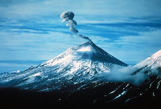
Pavlof Volcano is a stratovolcano of the Aleutian Range on the Alaska Peninsula. It has been one of the most active in the United States since 1980, with eruptions recorded in 1980, 1981, 1983, 1986–1988, 1996–1997, 2007, 2013, twice in 2014 and most recently in March 2016. Basaltic andesite with SiO2 around 53% is the most common lava type. The volcano is monitored by the Alaska Volcano Observatory- a joint program of the United States Geological Survey (USGS), the Geophysical Institute of the University of Alaska Fairbanks (UAFGI), and the State of Alaska Division of Geological and Geophysical Surveys (ADGGS). With a threat score of 95, the threat from future eruptions is considered to be high; much of this threat comes from the possibility of disruption of nearby air routes by large releases of ash. The mountain currently has basic real-time monitoring, but the USGS would like to improve instrumentation at the site. The mountain shares a name with the nearby Pavlof Sister, which last erupted in 1786.

Bogoslof Island or Agasagook Island is the summit of a submarine stratovolcano at the south edge of the Bering Sea, 35 miles (56 km) northwest of Unalaska Island of the Aleutian Island chain. It has a land area of 319.3 acres (1.292 km2) and is uninhabited. The peak elevation of the island is 490 feet (150 m). It is 1,040 meters (3,410 ft) long and 1,512 m (4,961 ft) wide. The stratovolcano rises about 6,000 ft (1,800 m) from the seabed, but the summit is the only part that projects above sea level. The island is believed to be relatively new, with the volcano being entirely below sea level before 1796, and most of the presently 300 acre island being formed by eruptions since 1900.

Mount Okmok is the highest point on the rim of Okmok Caldera on the northeastern part of Umnak Island in the eastern Aleutian Islands of Alaska. This 5.8 mile (9.3 km) wide circular caldera truncates the top of a large shield volcano. A crater lake once filled much of the caldera, but the lake ultimately drained through a notch eroded in the northeast rim. The prehistoric lake attained a maximum depth of about 150 m (500 ft) and the upper surface reached an elevation of about 475 m (1560 ft), at which point it overtopped the low point of the caldera rim. Small, shallow remnants of the lake remained north of Cone D at an altitude of about 1075 feet: a small shallow lake located between the caldera rim and Cone D; a smaller lake farther north near the caldera's gate. After the 2008 eruption, the hydrogeology of the caldera was greatly changed with five separate sizable lakes now emplaced. In addition to the caldera lakes, Cone A, Cone E, Cone G and the new 2008 vent on Cone D contain small crater lakes. The last major eruptions of Okmok—with a VEI strength of 6—occurred 8,300 and 2,400 years Before Present.

Mount Cleveland is a nearly symmetrical stratovolcano on the western end of Chuginadak Island, which is part of the Islands of Four Mountains just west of Umnak Island in the Fox Islands of the Aleutian Islands of Alaska. Mt. Cleveland is 5,675 ft (1,730 m) high, and one of the most active of the 75 or more volcanoes in the larger Aleutian Arc. Aleutian natives named the island after their fire goddess, Chuginadak, who they believed inhabited the volcano. In 1894 a team from the U.S. Coast and Geodetic Survey visited the island and gave Mount Cleveland its current name, after then-president Grover Cleveland.
The undissected stratovolcano of Amukta volcano makes up most of nearly circular, 7.7-km-wide Amukta Island. It is the westernmost of the Islands of Four Mountains chain. The cone, about 5.8 km in basal diameter and topped by a 0.4 km wide summit crater, appears on synthetic-aperture radar imagery to be built upon a 300+ meter high, east-west trending arcuate ridge. Extensions of that ridge on the southwest and east sides of the island indicate an older caldera approximately 6 km in diameter and open to the sea on the south side. No hot springs or fumaroles have been reported from Amukta. Sekora reports the presence of a cinder cone near the northeastern shore of the island.

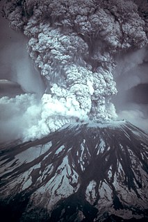
An eruption column or eruption plume is a cloud of super-heated ash and tephra suspended in gases emitted during an explosive volcanic eruption. The volcanic materials form a vertical column or plume that may rise many kilometers into the air above the vent of the volcano. In the most explosive eruptions, the eruption column may rise over 40 km (25 mi), penetrating the stratosphere. Stratospheric injection of aerosols by volcanoes is a major cause of short-term climate change.
Prediction of volcanic eruption, or volcanic eruption forecasting, is an interdisciplinary monitoring and research effort to predict the time and severity of a volcano's eruption. Of particular importance is the prediction of hazardous eruptions that could lead to catastrophic loss of life, property, and disruption of human activities.

The Alaska Volcano Observatory (AVO) is a joint program of the United States Geological Survey, the Geophysical Institute of the University of Alaska Fairbanks, and the State of Alaska Division of Geological and Geophysical Surveys (ADGGS). AVO was formed in 1988, and uses federal, state, and university resources to monitor and study Alaska's volcanology, hazardous volcanoes, to predict and record eruptive activity, and to mitigate volcanic hazards to life and property. The Observatory website allows users to monitor active volcanoes, with seismographs and webcameras that update regularly. AVO now monitors more than 20 volcanoes in Cook Inlet, which is close to Alaskan population centers, and the Aleutian Arc due to the hazard that plumes of ash pose to aviation.

On 15 December 1989, KLM Flight 867, en route from Amsterdam to Narita International Airport Tokyo, was forced to make an emergency landing at Anchorage International Airport Alaska when all four engines failed. The Boeing 747-400 combi, less than six months old at the time, flew through a thick cloud of volcanic ash from Mount Redoubt, which had erupted the day before.
Bernard A. Chouet is a geophysicist who specializes in volcanic seismology. He discovered that volcanic eruptions could be predicted by observing the frequency of certain seismic waves that are generated by volcanoes.

Alaska's Mount Redoubt volcano began erupting on March 22, 2009, and activity continued for several months.
A Volcanic Ash Advisory Center (VAAC) is a group of experts responsible for coordinating and disseminating information on atmospheric volcanic ash clouds that may endanger aviation. As at 2019, there are nine Volcanic Ash Advisory Centers located around the world, each one focusing on a particular geographical region. Their analyses are made public in the form of Volcanic Ash Advisories (VAA), involving expertise analysis of satellite observations, ground and pilot observations and interpretation of ash dispersion models.

Volcanic ash consists of fragments of rock, minerals, and volcanic glass, created during volcanic eruptions and measuring less than 2 mm (0.079 inches) in diameter. The term volcanic ash is also often loosely used to refer to all explosive eruption products, including particles larger than 2 mm. Volcanic ash is formed during explosive volcanic eruptions when dissolved gases in magma expand and escape violently into the atmosphere. The force of the gasses shatters the magma and propels it into the atmosphere where it solidifies into fragments of volcanic rock and glass. Ash is also produced when magma comes into contact with water during phreatomagmatic eruptions, causing the water to explosively flash to steam leading to shattering of magma. Once in the air, ash is transported by wind up to thousands of kilometres away.
Dispersal index is a parameter in volcanology. The dispersal index was defined by George P. L. Walker in 1973 as the surface area covered by an ash or tephra fall, where the thickness is equal or more than 1/100 of the thickness of the fall at the vent. An eruption with a low dispersal index leaves most of its products close to the vent, forming a cone; an eruption with a high dispersal index forms thinner sheet-like deposits which extends to larger distances from the vent. A dispersal index of 500 square kilometres (190 sq mi) or more of coarse pumice is one proposed definition of a Plinian eruption. Likewise, a dispersal index of 50,000 square kilometres (19,000 sq mi) has been proposed as a cutoff for an ultraplinian eruption. The definition of 1/100 of the near-vent thickness was partially dictated by the fact that most tephra deposits are not well preserved at larger distances.
References
- Casadevall, T. J. (1994). The 1989/1990 eruption of Redoubt Volcano Alaska: impacts on aircraft operations. Journal of Volcanology and Geothermal Research.62 (30). pp. 301–316.
- Keith, T. E. C., (ed.), 1995. The 1992 eruptions of Crater Peak Vent, Mount Spurr volcano, Alaska. U.S. Geological Survey Bulletin.2139 p. 220
- Miller, T. P., and Chouet, B. A., 1994, The 1989-1990 eruptions of Redoubt volcano: an introduction in: Miller, T. P. and Chouet, B. A., (eds.), The 1989-1990 eruptions of Redoubt Volcano, Alaska, Journal of Volcanology and Geothermal Research. (1), p. 10.
- Searcy, C., Dean, K. and Stringer, W. (1998). PUFF: A high-resolution volcanic ash tracking model. Journal of Volcanology and Geothermal Research. 80. p. 1-16.