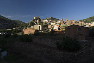
Pratdip is a municipality in the comarca of Baix Camp, in the province of Tarragona, Catalonia, Spain.

The Statistical Institute of Catalonia is the official body responsible for collecting and publishing statistics in the autonomous community of Catalonia, Spain. The institute comes under the Department of the Economy and Finances of the Generalitat de Catalunya.

The Barcelona–Vallès Line is an unconnected standard gauge railway line linking Barcelona with Sabadell and Terrassa via the Collserola mountain range, in Catalonia, Spain. Its name refers to the Catalan historical region of Vallès, whereby most part of the line runs. Plaça de Catalunya station serves as the Barcelona terminus of the line, where almost all its trains either start or terminate. The line then continues northwards and branches off twice before leaving the city limits. Its main route splits in two in Sant Cugat del Vallès, forming two major branches to Sabadell and Terrassa. It has 40 passenger stations in operation and a total line length of 48.1 kilometres (29.9 mi).
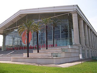
Teatre Nacional de Catalunya is a public theatre in Barcelona, Catalonia, Spain created by the Culture Department of the Catalan Government.

Bràfim is a municipality in the comarca of Alt Camp, province of Tarragona, Catalonia, in north-eastern Spain. This town produces quite good table wine.

Dreta de l'Eixample is a neighborhood in the Eixample district of Barcelona, Catalonia (Spain). It is located east of Carrer de Balmes. It includes Plaça de Catalunya, the centre of the city, and the upscale streets Rambla de Catalunya and Passeig de Gràcia. It is the bourgeois neighborhood of the city, which makes the majority of its population belong to the upper class of Barcelona. Dreta de L'Eixample is one of the most luxurious neighbors of Barcelona.
Turó de Morou is a mountain of Catalonia, Spain. It has an elevation of 1,303 metres above sea level.
Turó del Samont is a mountain of Catalonia, Spain. It has an elevation of 1,272 metres above sea level.

Sant Jeroni is a mountain of Catalonia, Spain. It has an elevation of 1,236 metres above sea level.
Turó de Bellver is a mountain of Catalonia, Spain. It has an elevation of 1,041 metres above sea level.
Puig Castellar (Balenyà) is a mountain of Catalonia, Spain. It has an elevation of 1,017 metres above sea level.
Punta de la Barrina is a mountain of Catalonia, Spain. It has an elevation of 1,013 metres above sea level.
Turó de Sant Elies is a mountain of Catalonia, Spain. It has an elevation of 1,003 m (3,291 ft) above sea level.

Turó de la Creu de Gurb is a mountain of Catalonia, Spain. It has an elevation of 841 metres above sea level.
Puig-l'agulla is a mountain of Catalonia, Spain. It has an elevation of 810 metres above sea level.
Turó Gros is a mountain of Catalonia, Spain. It has an elevation of 766 metres above sea level.
Puig Cornador is a mountain of Catalonia, Spain. It has an elevation of 621 metres above sea level.

The 2010 Catalan autonomy protest was a demonstration in central Barcelona on 10 July 2010 against limitations of the autonomy of Catalonia, and particularly against a recent decision of the Spanish Constitutional Court to annul or reinterpret several articles of the 2006 Statute of Autonomy of Catalonia. The number of people taking part in the demonstration was estimated at between 1.1 million and 1.5 million, while Madrid-based newspaper El País estimated the number of demonstrators at 425,000. The mobilisation was described as "unprecedented" by the mayor of Barcelona. The Barcelona daily newspaper El Periódico de Catalunya described it as "without a doubt one of the biggest protest marches that has ever occurred in Catalonia, possibly the biggest". It is thought that the 2012 Catalan independence demonstration involved more people, but this protest brought the dispute to light in the world.

The Catalan Transversal Range is a system of minor mountain ranges at the eastern end of the Pre-Pyrenees, between the Osona and Garrotxa comarques. The existence of the Catalan Transversal Range has made communications in the northern areas of Catalonia difficult in the past, especially between Northeastern Catalonia and Western Catalonia, a problem that has been partly solved with the development of the Eix Transversal.
The Rec Comtal was an irrigation canal near Barcelona, Catalonia, which took water from the Besòs river to the walls of the city. Construction was begun by Miro, Count of Barcelona in the 10th century, but it may date back to Roman times. It supplied water until the mid-20th century. In March 2016, extensive remains of structures associated with the system were discovered during excavations at Plaça de les Glòries Catalanes.


