
Lake Huron is one of the five Great Lakes of North America. Hydrologically, it comprises the easterly portion of Lake Michigan–Huron, having the same surface elevation as its westerly counterpart, to which it is connected by the 5-mile-wide (8.0 km), 20-fathom-deep Straits of Mackinac. It is shared on the north and east by the Canadian province of Ontario and on the south and west by the state of Michigan in the United States. The name of the lake is derived from early French explorers who named it for the Huron people inhabiting the region. The Huronian glaciation was named due to evidence collected from Lake Huron region. The northern parts of the lake include the North Channel and Georgian Bay. Across the lake to the southwest is Saginaw Bay. The main inlet is the St. Marys River, and the main outlet is the St. Clair River.

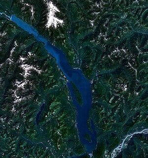
Lake Baikal is a rift lake in Russia, located in southern Siberia, between Irkutsk Oblast to the northwest and the Buryat Republic to the southeast.

The Caloosahatchee River is a river on the southwest Gulf Coast of Florida in the United States, approximately 67 miles (108 km) long. It drains rural areas on the northern edge of the Everglades, east of Fort Myers. An important link in the Okeechobee Waterway, a manmade inland waterway system of southern Florida, the river forms a tidal estuary along most of its course and has become the subject of efforts to restore and preserve the Everglades.
The Miami River is a 13.7-mile-long (22.0 km) stream in upstate New York and is a part of the Hudson River watershed. The river's headwaters rise in the Adirondack Mountains at 43°36′11″N74°30′12″W about 10 miles (16 km) northwest of Speculator and flows southeast for about 3 miles (5 km) with Pillsbury Mountain on the southwest and Page Mountain to the northeast. It turns sharply southwest for about one mile and then turns sharply east for about a mile, after which it flows mostly northeast for about 8 miles (13 km) before flowing into Lewey Lake at 43°37′58″N74°24′17″W. Lewey Lake empties into Indian Lake, which is drained by the Indian River, which then flows into the Hudson River approximately 17 miles (27 km) to the northeast of Lewey Lake.

Mjøsa is Norway's largest lake, as well as one of the deepest lakes in Norway and in Europe. It is the fourth-deepest lake in Norway. It is located in the southern part of Norway, about 100 km north of Oslo. Its main tributary is Gudbrandsdalslågen in the north; the only distributary is Vorma in the south. Inflows would theoretically need 5.6 years to fill the lake. With an average depth of 153 meters most of the lakes volume is under sea level. Average outflow is 316 m3/s or 9959 million m3. Mjøse contains about 56 km3 of water compared to 15 km3 of Røssvatnet, the second largest volume of lakes in Norway.

Lake Conroe is a 21,000-acre (85 km2) lake in Montgomery County, Texas, United States. Even though it is named Lake Conroe, only a small portion of the lake is in Conroe, Texas. Most of the lake is in unincorporated Montgomery County. The lake lies on the West Fork of the San Jacinto River, just west of Interstate 45 off State Highway 105 in Montgomery and Walker counties. Lake Conroe is a popular attraction for boating, jet-skiing, and fishing.

The Ocala National Forest ls the second largest nationally protected forest in the U.S. State of Florida. It covers 607 square miles (1,570 km2) of Central Florida. It is located three miles (5 km) east of Ocala and 16 miles (26 km) southeast of Gainesville. The Ocala National Forest, established in 1908, is the oldest national forest east of the Mississippi River and the southernmost national forest in the continental U.S. The word Ocala is thought to be a derivative of a Timucuan term meaning "fair land" or "big hammock". The forest is headquartered in Tallahassee, as are all three National Forests in Florida, but there are local ranger district offices located in Silver Springs and Umatilla.
Harrison Lake is the largest lake in the southern Coast Mountains of Canada, being about 250 square kilometres (95 mi²) in area. It is about 60 km (37 mi) in length and at its widest almost 9 km (5.6 mi) across. Its southern end, at the resort community of Harrison Hot Springs, is c. 95 km east of downtown Vancouver. East of the lake are the Lillooet Ranges while to the west are the Douglas Ranges. The lake is the last of a series of large north-south glacial valleys tributary to the Fraser along its north bank east of Vancouver, British Columbia. The others to the west are the Chehalis, Stave, Alouette, Pitt, and Coquitlam Rivers.
Premier Lake Provincial Park is a provincial park near Sparwood, British Columbia, Canada. It is located on the south and western shores of Premier Lake in the East Kootenays, a small lake situated on the eastern flank of the Kootenay trench about 50 km north of Cranbrook. Also contained within the park are several smaller lakes, including Rockbluff (Quartz) Lake, Yankee Lake and Canuck Lake, all notable for the vivid green colour of their water.
Bandak is a lake in the municipalities of Kviteseid and Tokke in Telemark county, Norway. The lake, which is part of the Telemark Canal route, belongs to the Skien watershed. The river Tokke flows into the lake, and the outlet is via the river Straumane, to Kviteseidvatn. Average depth is 121 meter or about 50 meters below sea level. The lake is 2 km at the widest. The catchment area is 2556 km2.

Sønningen is a lake in the municipality of Levanger in Trøndelag county, Norway. The 0.86 km2 (210-acre) lake lies about 2.5 km (1.6 mi) southwest of the village of Ekne, about 2 km (1.2 mi) west of the lake Byavatnet, and about 2.3 kilometres (1.4 mi) southeast of the shore of the Trondheimsfjorden.

The Millers River is a 52.1-mile-long (83.8 km) river in northern Massachusetts, originating in Ashburnham and joining the Connecticut River just downstream from Millers Falls, Massachusetts. The river was formerly known as Paquag or Baquag, a Nipmuc word meaning "clear water". Sections of the river are used for whitewater kayaking, and a section upriver is popular with flatwater racers.
Highway 941 is a highway in the Canadian province of Saskatchewan. It runs from Highway 904 to the Waterhen Lake First Nation. Highway 941 is about 22 km (14 mi) long.
Highway 917 is a provincial highway in the northwest region of the Canadian province of Saskatchewan. It runs from Highway 916 to a dead end near Doré Lake. Highway 917 is about 25 km (16 mi) long.

Veeranam Lake is located 14 km (8.7 mi) SSW in Cuddalore district in the state of Tamil Nadu in South India. It is located 1 km (0.62 mi) from Kattumannarkoil and 235 km (146 mi) from Chennai, India. It is one of the water reservoirs from where water is supplied to Chennai city. The lake has a capacity to store about 1,465 mcft of water. Though the level in the Veeranam lake has dipped to 323 million cubic feet (mcft), the same amount of 180 mld was being drawn for city supply.
Highway 905 is a provincial highway in the far north region of the Canadian province of Saskatchewan. It runs from Highway 102 to Stony Rapids. The highway is approximately 469 km (291 mi) long and is entirely unpaved. A 185 km (115 mi) section between Points North Landing and Black Lake is a seasonal winter road.
The Pennamaquan River is a short, 8.1-mile (13 km) river in the U.S. state of Maine, draining from medium-sized, low-elevation Pennamaquan Lake into Cobscook Bay.
The West Branch Mattawamkeag River is a 52.6-mile-long (84.7 km) tributary of the Mattawamkeag River in Maine. From its source in Maine Township 6, Range 6, WELS, the river runs 10 miles (16 km) northeast by Pleasant Lake and through Mud Lake and Rockabema Lake, then 42 miles (68 km) south and southeast through Upper Mattawamkeag Lake and Mattawamkeag Lake to its confluence with the East Branch Mattawamkeag River in Haynesville, about 10 miles (16 km) west of the Canada–United States border.

Floras Lake is a natural 236-acre (96 ha) body of water on the southern Oregon Coast of the United States. Fed by four small tributaries from a basin of about 10 square miles (26 km2) in Curry County, it lies about 10 miles (16 km) north of Port Orford and 2 miles (3 km) west of U.S. Route 101. It was probably named for Fred Flora, a 19th-century settler and miner who lived nearby.
