Related Research Articles
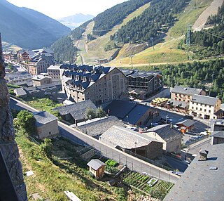
Soldeu is a village and ski resort in Andorra in the Pyrenees mountains, located in the parish of Canillo.

Panchayati raj is the system of local self-government of villages in rural India as opposed to urban and suburban municipalities.
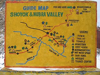
Tegar, also known as Kyagar, is a high-altitude village in the Leh district of Ladakh, India. It is located in the Nubra tehsil, in the Nubra Valley.

Kodai Road railway station is an NSG–5 category Indian railway station in Madurai railway division of Southern Railway zone. It is a railway station in Tamil Nadu state, India, lying between Dindigul and Madurai at 10°10′45″N77°54′34″E. It is formally listed as Kodaikanal Road.

Belotić or Mačvanski Belotić is a village in Serbia. It is situated in the Bogatić municipality, in the Mačva District. The village has a Serb ethnic majority and the population numbered 1,557 people in a 2011 census.

Barekamavan is a village in the Noyemberyan Municipality of the Tavush Province of Armenia.
Paghaghbyur is a village in the Lori Province of Armenia. The village was populated by Azerbaijanis before the exodus of Azerbaijanis from Armenia after the outbreak of the Nagorno-Karabakh conflict. In 1988-1989 Armenian refugees from Azerbaijan settled in the village.
Pələkli is a village in the Tovuz Rayon of Azerbaijan. The village forms part of the municipality of Çatax.

The Suchindram Theroor Vembannur Wetland Complex is a protected area comprising the Suchindram Kulam wetlands at 8°7′30″N77°27′30″E, and the Theroor Kulam wetlands at 8°10′45″N77°27′45″E, and the Vembannur Wetland Complex, all near Suchindram town in Kanyakumari District, Tamil Nadu, India. It is located between Nagercoil and Kanyakumari on the National Highway No. 47. Being at the extreme southern tip of India, this area underlies the southernmost continental range of the Central Asian Flyway. Constitution of this new wildlife sanctuary was proposed in 2002 and remains under consideration of the Government. International name is Suchindram Therur, Vembanoor, Important bird area code no. IN279, criteria: A1, A4i. Parts of the sanctuary have been designated as protected Ramsar sites since 2022.

The Thyagaraj Sport Complex is a sports stadium in New Delhi, India. It is owned by the Government of the National Capital Territory of Delhi and was built at the cost of ₹300 crore (US$36 million). It was designed by leading architects PTM of Australia and Kapoor & Associates of Delhi. The venue was built for the 2010 Commonwealth Games, and was named after the 18th century Telugu composer Thyagaraja.
The Jayanti Stadium in Bhilai is a multi-purpose stadium at Indra Place in Bhilai, India. The 20,000-capacity stadium is used mostly for football and field hockey and also for athletics.
Nevada is a village in the municipality of Kuršumlija, Serbia. According to the 2002 census, the village has a population of 30 people.

Klokočevac is a village in the municipality of Majdanpek, Serbia. According to the 2002 census, the village has a population of 711 people.
Rajaküla is a village in Vinni Parish, Lääne-Viru County, in northeastern Estonia. Between 1992 and 2017 the village was located in Laekvere Parish.
Kukunoor is a village in Eluru District of the Indian state of Andhra Pradesh. It was in Khammam district, until the formation of Telangana state in 2 June 2014.
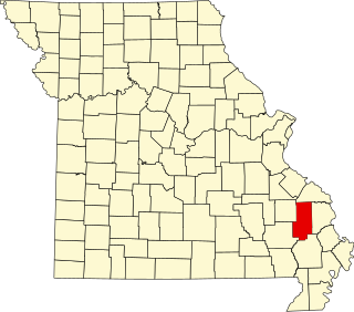
Lixville is an unincorporated community in the northeastern part of Whitewater Township in the northeast part of Bollinger County, Missouri, United States. Lixville lies seven miles northeast of Alliance. An early pioneer to settle in the area of Lixville was a German immigrant named Henry Lix. The community was officially established in 1897 and was named for the first post master, Louis W. Lix. A post office was in operation between the years 1895–1945.
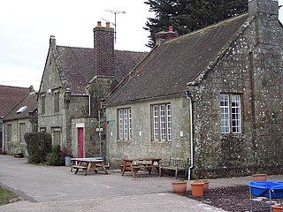
Sedgehill and Semley is a civil parish in the English county of Wiltshire, about 3 miles (4.8 km) north of the town of Shaftesbury on the main A350 road. It is in the southwest of Wiltshire and adjoins Dorset. The parish includes the villages of Sedgehill and Semley, and the hamlets of Barkers Hill and Sem Hill. The population of the parish at the 2021 census was 643.
Gidhour is a community development block that forms an administrative division in Simaria subdivision of Chatra district, Jharkhand state, India.
Barn is an unincorporated community in Mercer County, in the U.S. state of West Virginia.

Ichgam, also known as Ichigam, is a census town located in the Indian administered union territory of Jammu and Kashmir's Budgam district. It falls under the administrative division of tehsil Budgam, one of the nine tehsils of district Budgam. It is one of the most populated area of Budgam district. It is roughly 5 km (3.1 mi) away from district Budgam and nearly 19 km (12 mi) away from Srinagar, the summer capital of union territory of Jammu and Kashmir. Ichgam village consists of four blocks — Ichgam-A, Ichgam-B, Ichgam-C and Ichgam-D. The village consists of both major sects of Islam, Shias (85-90%) and Sunnis(10-15%). There is also a Hindu minority.
References
- ↑ "Villagers ostracised after voting for Congress". Rediff. 24 March 1998. Retrieved 2 December 2009.
- ↑ Singh, Rajinder Pal (1996). Census of India, 1991. Vol. 10. Delhi, India: Controller of Publications, Government of India. p. 110. OCLC 187460550.
- ↑ "Pulaparru VILLAGE". OurVillageIndia.org. Retrieved 2 December 2009.
6°34′37″N81°10′45″E / 6.57694°N 81.17917°E