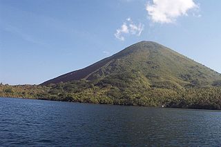
Makian is a volcanic island, one of the Maluku Islands within the province of North Maluku in Indonesia. It lies near the southern end of a chain of volcanic islands off the western coast of Halmaherato, to the south of Tidore and to the north of Kayoa and Bacan.

The Barat Daya Islands are a group of islands in the Maluku province of Indonesia. The Indonesian phrase barat daya means 'south-west'.
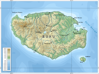
Buru is the third largest island within Maluku Islands of Indonesia. It lies between the Banda Sea to the south and Seram Sea to the north, west of Ambon and Seram islands. The island belongs to Maluku province and includes the Buru and South Buru regencies. Their administrative centers, Namlea and Namrole, respectively, have ports and the largest towns of the island. There is a military airport at Namlea which supports civilian cargo transportation.
The Babar Islands(Indonesian: Kepulauan Babar) are located in Maluku Province, Indonesia between latitudes 7 degrees 31 minutes South to 8 degrees 13 minutes South and from longitudes 129 degrees 30 minutes East to 130 degrees 05 minutes East. Tepa is the administrative center of the Babar Islands municipality now reduced to encompass only the western half of Babar Island, Wetang Island and Dai Island. The town of Letwurung on the east side of Babar island is the capital of the new municipality called "East Babar" in the east half of the Babar Islands, consisting of the East half of Babar Island, Masela Island, and Dawera Island and Dawelor Island.
Kisar, also known as Yotowawa, is a small island in the Southwestern Moluccas in Indonesia. It is included within the Southernmost Islands District within the Southwest Islands Regency of the Maluku Province; the District also includes the larger Romang Island further north. It is one of the 92 officially listed outlying islands of Indonesia. The principal town is Wonreli, with 6,652 inhabitants at the 2010 Census.
Liran is a small island off the southwest coast of Wetar Island, Indonesia. The East Timorese island Atauro is 12 km to the southwest. Liran is the westernmost of the Barat Daya Islands in the province of Maluku.

The Leti Islands of Indonesia are part of the Maluku Islands, in southwest Maluku Province. The main islands are Moa, Leti and Lakor.

Romang is an island, part of Barat Daya Islands in Indonesia, located at 7.5833333°S 127.4333333°E, east of Wetar Island. Alternate names in use are Roma, Romonu and Fataluku. It is included within the Terselatan Islands District within the Barat Daya Islands Regency of the Maluku Province; the District also includes the smaller Kisar Island further south.

The Banyak Islands are a group of inhabited islands located between Simeulue and Nias off the western coast of Sumatra in Indonesia's Aceh Province. Surveys of the area approximate around 71 islands and additional mangrove stands in shallow off-shore areas, although locals count 99 islands. The largest island in the group is Tuangku, with the principal town of Haloban. Two other major islands located either side of Tuangku are Bangkaru and Ujung Batu. Tuangku is separated from Bangkaru by a fault line.
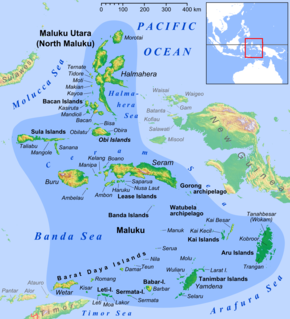
The province of Maluku in Indonesia is divided into nine regencies (kabupaten) and two independent cities (kota); these in turn are divided administratively into 118 districts known as Kecamatan. The 118 districts of Maluku, with the regency or city each falls into, are as follows:
The Timoric, or sometimes Timor–Babar, languages are a group of fifty Austronesian languages spoken on the islands of Timor, neighboring Wetar, and the Babar Islands to the east.

Southwest Maluku Regency is a regency of Maluku Province, Indonesia. It comprises a number of islands and island groups in the south of the province, including Liran Island, Wetar Island, Kisar Island, Romang Island, the Leti Islands, the Damar Islands, the Sermata Islands and the Babar Islands. The administrative centre lies at Tiakur on the Moa Island, but the largest town is Wonreli.

East Seram Regency is a regency of Maluku, Indonesia. It is mainly located on the island of Seram, but also includes smaller islands to the southeast such as Gorom and Wakate. The Regency covers a land area of 6,429.88 sq,km, and had a population of 99,065 at the 2010 Census; the latest official estimate was 110,350. The principal town lies at Bula.

Haruku Island is an island in Central Maluku Regency, Maluku Province, Indonesia - lying east of Ambon Island, off the southern coast of Seram and just west of Saparua. It is administered as a single district, Kecamatan Pulau Haruku, with a 2010 census population of 24,170. The inhabitants on Haruku speak the Haruku language, as well as Indonesian and Ambonese Malay.
Kisar is a Central Malayo-Polynesian language spoken on Kisar Island, northeast of East Timor in Maluku, Indonesia. It shares the island with Oirata, which is a Papuan language.

Manipa Island is an island in West Seram Regency, Maluku Province, Indonesia. It is located 8 km off the western coast of Kelang at the western end of Seram Island and 25 km off the western coast of Buru. The inhabitants speak the Manipa language, as well as Indonesian and Ambonese Malay.
The Oirata–Makasai, or Eastern Timor, languages are a small family of Papuan languages spoken in eastern Timor and the neighboring island of Kisar.
Damer, or Damar, is a small volcanic island in the Barat Daya Islands group in Indonesia's Maluku province, on the southern side of the Banda Sea.