
Portland is the most populous city in the U.S. state of Maine and the seat of Cumberland County. Portland's population was 68,408 in April 2020. The Greater Portland metropolitan area has a population of approximately 550,000 people. Historically tied to commercial shipping, the marine economy, and light industry, Portland's economy in the 21st century relies mostly on the service sector. The Port of Portland is the second-largest tonnage seaport in the New England area as of 2019.

Westbrook is a city in Cumberland County, Maine, United States and a suburb of Portland. The population was 20,400 at the 2020 census, making it the fastest-growing city in Maine between 2010 and 2020. It is part of the Portland–South Portland–Biddeford, Maine metropolitan statistical area.

Edward Payson Park is a 47.5-acre (19.2 ha) public park in the Back Cove neighborhood of Portland, Maine. The park is bordered by Ocean Avenue to the north and Baxter Boulevard to the south. The offices of the Roman Catholic Diocese of Portland are located across from the park on Ocean Avenue.
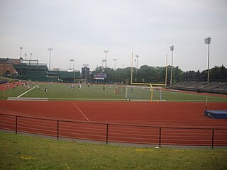
James J. Fitzpatrick Stadium is a 6,000 seat multi-purpose outdoor stadium in Portland, Maine, United States. It is located between Interstate 295, Hadlock Field baseball stadium, King Middle School, and the Portland Exposition Building. It is located across the street from Deering Oaks. Formerly known as Portland Stadium, it was renamed in 1989 to honor James J. Fitzpatrick, one of the most respected figures in Maine athletic history.

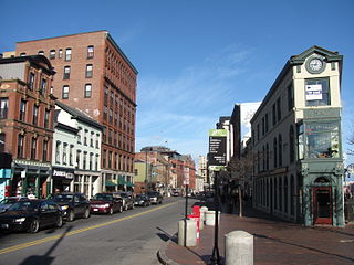
Exchange Street is a main commercial thoroughfare in the Old Port of Portland, Maine, United States. Originally laid out in 1724, today it features a number of designer clothing stores, as well as several small, locally owned businesses, including Sherman's Maine Coast Books. It runs, one-way, for around 0.24 miles (0.39 km), from Congress Street in the northwest to Fore Street in the southeast. Its main intersections are with Congress Street, Federal Street, Middle Street and Fore Street.

The great fire of Portland, Maine, sometimes known as the 1866 great fire of Portland, occurred on July 4, 1866—the second Independence Day after the end of the American Civil War. Five years before the Great Chicago Fire, this was the greatest fire yet seen in an American city. It started in a boat house on Commercial Street, likely caused by a firecracker or a cigar ash. The fire spread to a lumber yard and on to a sugar house, then spread across the city, eventually burning out on Munjoy Hill in the city's east end. Two people died in the fire and 10,000 people were made homeless. 1,800 buildings were burned to the ground. This included the federal Exchange Building by which was replaced with the custom house. Soon after the fire, Portland native and acclaimed poet Henry Wadsworth Longfellow described his old home town: "Desolation, desolation, desolation. It reminded me of Pompeii, that 'sepult city."
The Maine Mall is an enclosed shopping mall in South Portland, Maine, United States. Owned and managed by Brookfield Properties, it is the largest shopping mall in the state of Maine, and the second-largest in northern New England, behind New Hampshire's the Mall at Rockingham Park.

Franklin Towers is a 16-story high-rise building located in Portland, Maine, at the corner of Franklin Street and Cumberland Avenue, rising to a height of 175 feet (53 m). Construction was completed in 1969, and its primary use is residential. It was listed on the National Register of Historic Places in 2024.
Kennedy Park is a neighborhood in East Bayside in downtown Portland, Maine, built around a park, athletic fields, basketball courts, a playground and the Boyd Street Urban Garden.
The West End is a downtown neighborhood in Portland, Maine. It is located on the western side of Portland's peninsula primarily on Bramhall Hill and is noted for its architecture and history. The neighborhood is home to many late 19th- and early 20th-century homes and, in 2010, it was called "one of the best preserved Victorian neighborhoods in the country". The Western Promenade, a park laid out in 1836, overlooks the forests and small settlements of Southwestern Maine, along with the distant White Mountains. Other historic structures include 68 High Street, The Gothic House, Brown House, Butler House, Ingraham House, Morrill Mansion and the Minott House.

East Bayside is a neighborhood in Portland, Maine. It is bordered by Franklin Street on the west, Washington Avenue on the east, to the north by Marginal Way, and the south by Congress Street. It is bordered by the neighborhoods of Bayside, the Old Port and Munjoy Hill. It is often confused with the Bayside neighborhood, which is on the opposite side of Franklin Street.
The Portland Farmers Market is a farmers market in Portland, Maine, U.S., which has been in continuous operation since 1768. Since 1990, the market has been held place year-round. From May to November, it is held on Wednesdays in Monument Square and on Saturdays in Deering Oaks Park. From December to April, the winter market is held on Saturdays in the former Catherine McAuley High School building.
The Arts District is a section of downtown Portland, Maine’s designated in 1995 as to promote the cultural community and creative economy of the city. It covers a large part of upper Congress Street towards the West End and spans Congress Street toward the East ending at Portland City Hall and its Merrill Auditorium concert hall.

Florence House is a 31⁄2 story building in Portland, Maine, United States, named after Florence Young "a social worker who spent more than 20 years working at Preble Street."
Commercial Street is a downtown street in the Old Port of Portland, Maine, United States. It is part of U.S. Route 1A. It became the Old Port's waterfront in the early 20th century, replacing Fore Street, after land was reclaimed from the waters of Casco Bay and the Fore River.
The following is a timeline of the history of the city of Portland, Maine, USA.

The Baxter Building is an historic building located at 619 Congress Street in downtown Portland, Maine. Completed in 1888, it served as the Portland Public Library from its founding until 1978, when the Library moved to another location on Congress Street. The building went unused from 1978 to 1983, when it was purchased by the Maine College of Art (MECA). MECA utilized the space for studio space, dark rooms, as a computer lab and library. In 2010, MECA sold the building to Northland Enterprises LLC, which then leased it to the VIA Group.

The Press Herald Building is an historic building in Portland, Maine, built in 1923 and expanded in 1948. It is strategically located across Congress Street from Portland City Hall. It was occupied by the Portland Press Herald newspaper until 2010. In 2015, the renovated building reopened as the Press Hotel.
George Burnham was an American architect from Portland, Maine. He was active in the second half of the 20th century and first half of the 21st century.

India Street is a downtown street and neighborhood in Portland, Maine, United States. Situated near the western foot of Munjoy Hill, it runs for around 0.28 miles (0.45 km), from Congress Street in the northwest to Commercial Street and Thames Street in the southeast. It was the city's first street, and the location of the first settlement of European immigrants to the city in the 17th century. There are thirty handmade bricks in the sidewalk commemorating the neighborhood's notable events. In 1680, when Thomas Danforth was Deputy Governor of the Massachusetts Bay Colony, the street was known as Broad Street. After the incorporation of the Town of Falmouth in 1718, the street was known as High King Street.
