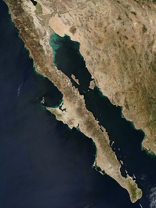
The Baja California peninsula is a peninsula in northwestern Mexico. It separates the Gulf of California from the Pacific Ocean. The peninsula extends from Mexicali, Baja California, in the north to Cabo San Lucas, Baja California Sur, in the south.
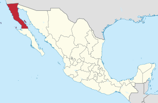
Baja California, officially the Free and Sovereign State of Baja California, is a state in Mexico. It is the northernmost and westernmost of the 32 federal entities of Mexico. Before becoming a state in 1952, the area was known as the North Territory of Baja California. It has an area of 70,113 km2 (27,071 sq mi) and comprises the northern half of the Baja California Peninsula, north of the 28th parallel, plus oceanic Guadalupe Island. The mainland portion of the state is bordered on the west by the Pacific Ocean; on the east by Sonora, the U.S. state of Arizona, and the Gulf of California; on the north by the U.S. state of California; and on the south by Baja California Sur.

Baja California Sur, officially the Free and Sovereign State of Baja California Sur, is the least populated state and the 31st admitted state of the 32 federal entities which comprise the 31 States of Mexico. It is also the ninth-largest Mexican state in terms of area.

Sierra de San Pedro Mártir is a mountain range located within southern Ensenada Municipality and southern Baja California state, of northwestern Mexico.

Ensenada is a city in Ensenada Municipality, Baja California, situated on the Pacific Coast of Mexico. Located on the Bahía de Todos Santos, the city had a population of 279,765 in 2018, making it the third-largest city in Baja California. The city is an important international trade center and home to the Port of Ensenada, the second-busiest port in Mexico. Ensenada is a major tourist destination, owing to its warm Mediterranean climate and proximity to the Pacific Ocean, and is commonly known as La Cenicienta del Pacífico.
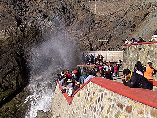
La Bufadora is a blowhole and tourist attraction located on the Punta Banda Peninsula in Baja California, Mexico, about 17 miles south of Ensenada.

In geology, a blowhole or marine geyser is formed as sea caves grow landward and upward into vertical shafts and expose themselves toward the surface, which can result in hydraulic compression of seawater that is released through a port from the top of the blowhole. The geometry of the cave and blowhole along with tide levels and swell conditions determine the height of the spray.

The municipality of Ensenada is the fourth-largest municipality in Mexico with a land area of 19,526.8 km2 (7,539.3 sq mi) in 2020, about the same size as Hidalgo state and larger than five Mexican states.

Federal Highway 1 is a free (libre) part of the federal highway corridors of Mexico, and the highway follows the length of the Baja California Peninsula from Tijuana, Baja California, in the north to Cabo San Lucas, Baja California Sur, in the south. The road connects with Via Rapida, which merges into the American Interstate 5 (I-5) at the San Ysidro Port of Entry, which crosses the international border south of San Ysidro, California.

Todos Santos is a small coastal town in the foothills of Mexico's Sierra de la Laguna Mountains, on the Pacific coast side of the Baja California Peninsula, about an hour's drive north of Cabo San Lucas on Highway 19 and an hour's drive southwest from La Paz. Todos Santos is located near the Tropic of Cancer in the municipality of La Paz. The population was 6,485 at the census of 2015. It is the second-largest town in the municipality.

Isla Todos Santos is a pair of islands about 19.3 km (12.0 mi) off Ensenada, Baja California, at 31°47′59″N116°47′20″W best known for surfing. Access is only by boat, which can be rented in Ensenada, or La Bufadora. The waves off the smallest island are among the biggest in North America. There are no facilities on the islands except for two lighthouses and a fish farm operation.

XHFZO-FM is a Spanish & English Adult Contemporary language radio station in Ensenada, Baja California, Mexico, broadcasting on 92.9 FM. The station broadcasts from Cerro La Bufadora, located northwest of Ensenada.
Ribes viburnifolium, is an uncommon North American species in the gooseberry family. It is known by the common names Catalina currant, Santa Catalina Island currant, island gooseberry and evergreen currant.

Punta Colonet is a town located in Ensenada Municipality, Baja California, Mexico. Located 115 km (71 mi) south of the city of Ensenada, the community is located in an agriculturally productive region of Baja California spurred on by its location along Mexican Federal Highway 1 and proximity to agricultural markets in the United States.

The California coastal sage and chaparral is a Mediterranean forests, woodlands, and scrub ecoregion located in southwestern California and northwestern Baja California (Mexico). It is part of the larger California chaparral and woodlands ecoregion.

Bahía Todos Santos, or Bay of All Saints, is a sheltered bay in Ensenada, Baja California, Mexico. The bay is home to the deepwater busy international Port of Ensenada.

Punta Brava Golf Club is a private golf and surf club currently under development in Ensenada, Baja California, Mexico at the tip of the Punta Banda Peninsula. The site is framed by the Pacific Ocean on one side and the Bay of Todos Santos on the other. Golf course architect Tom Doak announced he will lead the project design on The Fried Egg podcast in 2022.
Brian Christopher Tucker worked at Charles Schwab Corporation and founded Punta Brava Golf Club, a private golf and surf club with Red McCombs. Tucker serves on the board of The Century Club of San Diego in support of San Diego community and local youth programs.

Dudleya attenuata is a species of perennial succulent plant known by the common name taper-tip liveforever, native to Baja California and a small portion of California. A rosette-forming leaf succulent, it has narrow pencil shaped leaves that can often be found covered in a white epicuticular wax. The thin, sprawling stems branch to form the clusters of rosettes, with plants creating a "clump" up to 40 cm wide. The small flowers are white or yellow, with 5 spreading petals. It is a diverse, variable species that extends from the southernmost coast of San Diego County to an area slightly north of the Vizcaino Desert, hybridizing with many other species of Dudleya in its range. Some plants with white or pinkish flowers were referred to as Orcutt's liveforever, referring to a former subspecies split on the basis of the flower color.
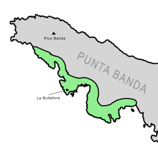
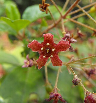
Dudleya campanulata is a species of perennial succulent plant known by the common name as the Punta Banda liveforever, native to Baja California and endemic to the Punta Banda peninsula, a promontory south of Ensenada that encloses the southern limit of the Bahía de Todos Santos, a deepwater bay. One of many species of Dudleya native to the peninsula and surrounding islands, it is distinguished by its campanulate flowers and its occupation of a narrow habitat that consists of ocean bluffs on the southern end of the Punta Banda, near the well-known blowhole La Bufadora.


