Punta de los Llanos | |
|---|---|
Municipality and village | |
| Country | |
| Province | La Rioja Province |
| Time zone | UTC−3 (ART) |
Punta de los Llanos is a municipality and village in La Rioja Province in northwestern Argentina. [1]
Punta de los Llanos | |
|---|---|
Municipality and village | |
| Country | |
| Province | La Rioja Province |
| Time zone | UTC−3 (ART) |
Punta de los Llanos is a municipality and village in La Rioja Province in northwestern Argentina. [1]

Bear Peninsula is a peninsula about 50 nautical miles long and 25 nautical miles wide which is ice-covered except for several isolated rock bluffs and outcrops along its margins, lying 3 nautical miles east of Martin Peninsula on Walgreen Coast, Marie Byrd Land, Antarctica.
Northeast Glacier is a steep, heavily crevassed glacier, 13 nautical miles long and 5 nautical miles wide at its mouth, which flows from McLeod Hill westward and then south-westwards into Marguerite Bay between the Debenham Islands and Roman Four Promontory, on the west coast of Graham Land, Antarctica.

German submarine U-550 was a Type IXC/40 German Navy U-boat built during World War II. She was laid down on 2 October 1942 by Deutsche Werft in Hamburg as yard number 371, launched on 12 May 1943 and commissioned on 28 July under the command of Kapitänleutnant Klaus Hänert.
German submarine U-253 was a Type VIIC U-boat built for Nazi Germany's Kriegsmarine for service during World War II.
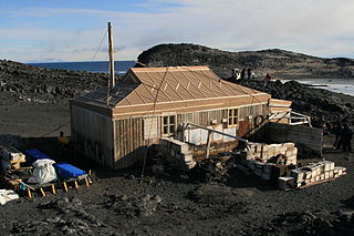
Cape Royds is a dark rock cape forming the western extremity of Ross Island, facing on McMurdo Sound, Antarctica. It was discovered by the British National Antarctic Expedition (BrNAE) (1901–1904) and named for Lieutenant Charles Royds, Royal Navy, who acted as meteorologist on the expedition. Royds subsequently rose to become an Admiral and was later Commissioner of the Metropolitan Police, London. The cape is the site of Shackleton's Hut, the expedition camp of the British Antarctic Expedition, 1907–09.

Busen Point or Busen Peninsula is a headland forming the southeast side of the entrance to Stromness Bay, on the north coast of South Georgia island. It lies on the Lewin Peninsula in between Stromness Bay and Cumberland West Bay.
Tamboara is a municipality in the state of Paraná in the Southern Region of Brazil.
Santa Mariana is a municipality in the state of Paraná in the Southern Region of Brazil.

Apoyaco is a village and municipality in Catamarca Province in northwestern Argentina bordering Chle. The indigenous Atacama people live in this province and village. The village and region is home to lamini, alpaca and llama herding as well as farming pumpkins, zucchini, chili, beans, tobacco, melon, corn, potatoes, and quinoa.
La Hoyada is a village and municipality in Catamarca Province in northwestern Argentina.
Nahuel Niyeu is a village and municipality in Río Negro Province in Argentina.
On the continent of Antarctica, the Aramis Range is the third range south in the Prince Charles Mountains, situated 11 miles southeast of the Porthos Range and extending for about 30 miles in a southwest–northeast direction. It was first visited in January 1957 by Australian National Antarctic Research Expeditions (ANARE) southern party led by W.G. Bewsher, who named it for a character in Alexandre Dumas' novel The Three Musketeers, the most popular book read on the southern journey.
The Anderson Hills are an irregular group of hills, ridges and peaks between Mackin Table and the Thomas Hills in the Patuxent Range, Pensacola Mountains, Antarctica.
Beaglehole Glacier is a glacier between Spur Point and Friederichsen Glacier on the east coast of Graham Land. It was named by the UK Antarctic Place-Names Committee after John Cawte Beaglehole, New Zealand historian of the Antarctic and biographer of Captain James Cook.
The Werner Mountains are a group of mountains located just west-southwest of New Bedford Inlet and between the Meinardus Glacier and Bryan Glacier, in Palmer Land, Antarctica.

Perutz Glacier is a glacier, 10 nautical miles (18 km) long and 2 nautical miles (3.7 km) wide, which flows west-northwest from Hemimont Plateau into Bourgeois Fjord, close east of Thomson Head, on the west coast of Graham Land, Antarctica. The mouth of the glacier was first surveyed in 1936 by the British Graham Land Expedition (BGLE) under Rymill. The entire glacier was surveyed in 1946-47 and 1948-49 by the Falkland Islands Dependencies Survey (FIDS), and named by them for Max F. Perutz of the Cavendish Laboratory, Cambridge, who has made important studies on the mechanism of glacier flow.
Friederichsen Glacier is a glacier 7 nautical miles (13 km) long, which flows in an easterly direction into Cabinet Inlet, close north of Mount Hulth, on the east coast of Graham Land, Antarctica. It was charted by the Falkland Islands Dependencies Survey (FIDS) and photographed from the air by the Ronne Antarctic Research Expedition in 1947. It was named by the FIDS for Ludwig Friederichsen, a German cartographer who in 1895 published a chart based upon all existing explorations of the Antarctic Peninsula and the South Shetland Islands.
The Reeves Glacier is a broad glacier originating on the interior upland and descending between Eisenhower Range and Mount Larsen to merge with the Nansen Ice Sheet along the coast of Victoria Land, Antarctica.
30°09′S66°33′W / 30.150°S 66.550°W
| | This article about a place in La Rioja Province, Argentina is a stub. You can help Wikipedia by expanding it. |