
The Taupō Volcanic Zone (TVZ) is a volcanic area in the North Island of New Zealand. It has been active for at least the past two million years and is still highly active.
Skelton Glacier is a large glacier flowing from the polar plateau into the Ross Ice Shelf at Skelton Inlet on the Hillary Coast, south of Victoria Land, Antarctica.

Moturoa / Rabbit Island is a small island that lies across the southernmost part of Tasman Bay / Te Tai-o-Aorere, on the northern coast of New Zealand's South Island. The long narrow island runs east–west for 8 kilometres (5 mi), and covers 15 km2 (5.8 sq mi).
The Prince Olav Mountains is a mountain group in the Queen Maud Mountains in Antarctica stretching from Shackleton Glacier to Liv Glacier at the head of the Ross Ice Shelf.

Mercury Bay is a large V-shaped bay on the eastern coast of the Coromandel Peninsula on the North Island of New Zealand. It was named by the English navigator Captain James Cook during his exploratory expeditions. It was first named Te-Whanganui-a-Hei, the great bay of Hei, by the Māori.

Te Onetapu, commonly known as the Rangipo Desert, is a barren desert-like environment located in New Zealand, located in the Ruapehu District on the North Island Volcanic Plateau; to the east of the three active peaks of Mount Tongariro, Mount Ngauruhoe, and Mount Ruapehu, and to the west of the Kaimanawa Range.

Convoy Range is a broad range in Antarctica. It is south of the Kirkwood Range and north of the Clare Range.

Purangi is a locality east of Inglewood, New Zealand, situated on the banks of the Waitara River. It is within the traditional tribal lands of Ngāti Maru iwi. Today, Ngāti Maru's headquarters are at Tarata. The Marae is called Te Upoko o te Whenua.

Manaia is a locality on the western side of the Coromandel Peninsula of New Zealand. It lies to the east of State Highway 25, south of Coromandel and north of Tapu. The Manaia River flows from the Coromandel Range through the area and into the Manaia Harbour to the west. The harbour contains mussel farms.
The Edison River is a river of the Westland District of New Zealand. It arises in the Solution Range near Mount Elliot and flows north-west and north into the Mahitahi River.
Pambula River is an open semi-mature wave dominated barrier estuary or perennial river located in the South Coast region of New South Wales, Australia.
The Kūaotunu River is a short river on the eastern Coromandel Peninsula on the North Island of New Zealand. It flows north towards the coast at Kūaotunu.
The Opitonui River is a river of the Coromandel Peninsula in New Zealand's North Island. It flows north to reach the peninsula's east coast at Whangapoua Harbour, close to the small settlement of Te Rerenga. The river provides a water supply for Matarangi by way of a pipe laid across the Whangapoua harbour.
The Waitekuri River is a river of the Coromandel Peninsula in New Zealand's North Island. It flows east from its sources in the Coromandel Range east of Coromandel to reach Whangapoua Harbour four kilometres south of Whangapoua.
The Wharekawa River is a river of the Coromandel Peninsula, in the Waikato Region of New Zealand's North Island. It flows northeast to reach the Wharekawa Harbour halfway between Pauanui and Whangamatā.
Canyon Glacier is a narrow glacier, 35 nautical miles long, flowing to the Ross Ice Shelf. It drains the northwest slopes of Mount Wexler and moves northward between steep canyon walls of the Separation Range and Hughes Range to join the ice shelf immediately west of Giovinco Ice Piedmont. The glacier was observed from nearby Mount Patrick by the New Zealand Alpine Club Antarctic Expedition (1959–60) who gave the descriptive name.
The Cumulus Hills are several groups of largely barren hills in Antarctica. Divided by the Logie Glacier, they are bounded by Shackleton Glacier on the west, McGregor Glacier on the north and Zaneveld Glacier on the south.

Eastern Creek, a watercourse that is part of the Hawkesbury-Nepean catchment, is located in Greater Western Sydney, New South Wales, Australia.
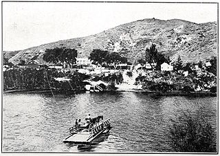
Upokongaro or Ūpokongaro is a settlement adjacent to the Whanganui River, located 12 kilometres (7.5 mi) upriver from Whanganui, New Zealand, in the Makirikiri Valley. Settled by Europeans in the 1860s, it was an important ferry crossing and riverboat stop. A spectacular discovery of moa bones was made in the area in the 1930s.

