This article needs additional citations for verification .(April 2018) |
Puravadayanar River is a branch river of Cauvery River in India. It flows through Karaikal district. It joins the Bay of Bengal near Karaikal Port. [1]
This article needs additional citations for verification .(April 2018) |
Puravadayanar River is a branch river of Cauvery River in India. It flows through Karaikal district. It joins the Bay of Bengal near Karaikal Port. [1]

Puducherry, also known as Pondicherry or Pondichéry, is a union territory of India, consisting of four small geographically unconnected districts. It was formed out of four territories of former French India, namely Pondichéry, Karikal (Karaikal), Mahé and Yanaon, excluding Chandannagar (Chandernagore), and it is named after the largest district, Puducherry, which was also the capital of French India. Historically known as Pondicherry, the territory changed its official name to Puducherry on 20 September 2006.
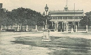
Karaikal is a town of the Indian Union Territory of Puducherry. Karaikal was sold to the French by the Rajah of Thanjavur and became a French Colony in 1739. The French held control, with occasional interruptions from the British, until 1954, when it was de facto incorporated into the Republic of India, along with Mahé, Yanaon, and Pondichéry.

The Coromandel Coast is the southeastern coastal region of the Indian subcontinent, bounded by the Utkal Plains to the north, the Bay of Bengal to the east, the Kaveri delta to the south, and the Eastern Ghats to the west, extending over an area of about 22,800 square kilometres. The coast has an average elevation of 80 metres and is backed by the Eastern Ghats, a chain of low lying and flat-topped hills.

Google Maps is a web mapping platform and consumer application offered by Google. It offers satellite imagery, aerial photography, street maps, 360° interactive panoramic views of streets, real-time traffic conditions, and route planning for traveling by foot, car, bike, air and public transportation. As of 2020, Google Maps was being used by over one billion people every month around the world.

Ilaiyangudi is a town in Sivaganga district, Tamil Nadu state, India. It is the center of government for the surrounding tehsils. The town has a predominant Muslim population. Islam was introduced to Ilayangudi during the 15th and 16th centuries by Arab traders. The Tamil Muslim community was traditionally engaged in Business. Bazaar(Kadai Theru) is the central business district.

Thirunallar is a small town in Karaikal, India, in the Union Territory of Puducherry, and can be reached by road from the town of Karaikal, an enclave which lies within the neighbouring state of Tamil Nadu. Thirunallar contains the shrine of Lord Sani (Saturn), Tirunallar Saniswaran Temple within the temple dedicated to Lord Darbharanyeswaran, a form of Lord Shiva.
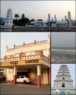
Nagore is a town in the Nagapattinam District, Tamil Nadu, India. It is located approximately 12 km North of Karaikal and 5 km South of Nagapattinam. Nearby towns are Karaikal, Tiruvarur, and Velankanni. It has a population of approximately 39,000. The prime attraction of the town is the Nagore Dargah Shareef. A sixteenth-century Islamic shrine, Nagore Dargah attracts millions of pilgrims irrespective of caste, creed or religion.
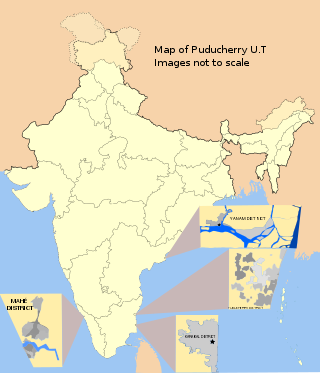
Karaikal district is one of the four districts of the Union Territory of Puducherry in India.
The river Arasalar is a river that flows through Tamil Nadu and Pudducherry, and a tributary of Kaveri river which splits into 5 different rivers when it enters into Thanjavur district from Trichy. It separates from river Kaveri in the place near Pullambadi where the Kaveri is stopped by Lower Anaicut and from Thiruvaiyaru. The river is one of the seven rivers that run in the Karaikal region of Puducherry.

Tirumalairayanpattinam is a census town and commune in the Karaikal District of Puducherry, India. Tirumalairayanpattinam is situated at a distance of 6 kilometres to the south of Karaikal municipality.
Thirumalairajan is a river flowing in the Thanjavur, Tiruvarur and Nagapattinam districts of the Indian state of Tamil Nadu and Karaikal district of Puducherry. The river splits from Kudamurutti, a tributary of Kaveri river at Rajagiri near Papanasam, Thanjavur district. The river enters Bay of Bengal at Tirumalarajanpattinam near Karaikal.The river has a 150 years old bridge built by a king, who ruled the nearby places of the river.The bridge is also named after the river, the thirumalairajan river bridge.
Karaikal Airport under construction at Karaikal, in the union territory of Puducherry, India. The District Administration of Karaikal had acquired around 300 acres of land in 2013 near Nedungadu and handed over to Coimbatore based Super Airport Infrastructure Private Limited to build the airport. By August 2019, since no progress had been made in executing the project and since the licence issued to the company had expired, the district administration decided to engage CIAL, the operators of Cochin International Airport to advise it on carrying the airport project forward.

Tiruchirappalli railway division(Tamil: [ திருச்சிராப்பள்ளி ரயில் கோட்டம்]) is one of the six railway divisions of Southern Railway zone (SR) of India. It has its administrative headquarters located at Tiruchirappalli. It serves most of the districts of delta region and Central Tamil Nadu.
Nagapattinam Junction is a junction railway station serving the town of Nagapattinam in Tamil Nadu, India.
Peralam Junction railway station is a railway junction station serving the village of Peralam in Tamil Nadu, India.
Vishnampettai is a large village in Budalur block, Thiruvaiyaru taluk of Thanjavur district, Tamil Nadu. This village is located in the banks of Kaveri River, Kollidam River and Kudamurutti River.
Vizhithiyur is a village in Puducherry, India. It is one of the three revenue villages in Neravy Taluk, Karaikal district. It is located west from Karaikal city.

The Carnon River is a heavily polluted river in Cornwall, United Kingdom. It starts in Chacewater. Trewedna Water and River Kennall flow into the Carnon before it merges with Tallack's Creek to become Restronguet Creek, which eventually flows into the English Channel at the mouth of Carrick Roads.
Rajacholeesvarar Temple is a Hindu temple dedicated to the deity Shiva, located at Thirumalairayanpattinam in Karaikal district, in Puducherry, India.