
Purbeck's Cove
Location of Purbeck's Cove in Newfoundland and Labrador
Purbeck's Cove is a settlement in Newfoundland and Labrador. [1]
Purbeck's Cove is a settlement in Newfoundland and Labrador. [1]
Division No. 1, Subdivision A is an unorganized subdivision on the Avalon Peninsula in Newfoundland and Labrador, Canada. It is in Division No. 1, and lies between Trinity Bay and Placentia Bay.
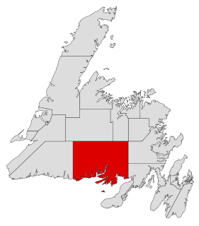
Fortune Bay—Cape La Hune is a provincial electoral district for the House of Assembly of Newfoundland and Labrador, Canada. When created in 1975 it was called Fortune-Hermitage. As of 2011, there are 6,053 eligible voters living within the district.

Baie Verte-Green Bay is a provincial electoral district for the House of Assembly of Newfoundland and Labrador, Canada. As of 2011 it has 8,067 eligible voters. The district was redistributed in 2015.

Baie Verte is a town located on the north coast of the island portion of the Canadian province of Newfoundland and Labrador on the Baie Verte Peninsula.
Victoria Cove, Newfoundland is situated on the west side of Gander Bay, near the town of Gander.
Back Cove is a hamlet on the Labrador Coast. The nearest port of call is Dead Island, Labrador.
Bayview is a collaboration of small fishing communities along the southern island of Twillingate, Newfoundland and Labrador. The communities within Bayview were formerly called Bluff Head Cove, Gillard's Cove, Manuel's Cove and Ragged Point. Older residents of the community still refer to these places separately but street signs only read Bayview and Ragged Point.
Route 410, also known as Dorset Trail, is a 89.9-kilometre-long (55.9 mi) north-south highway on the northern coast of Newfoundland in the Canadian province of Newfoundland and Labrador. It leads from Sheppardville, at Route 1, to a dead end in Fleur de Lys, Newfoundland and Labrador. Route 410 serves as the primary roadway access on-and-off the Baie Verte Peninsula.

Humber Arm South is a town in the Canadian province of Newfoundland and Labrador. The town had a population of 1,599 in the Canada 2016 Census. The Town's Post Office is located in the section of the town referred to as Benoit's Cove. Humber Arm South is located in the Bay of Islands, and is in the Humber-Bay of Islands electoral district.
Miles Cove is a town on Sunday Cove Island in the Canadian province of Newfoundland and Labrador. The town had a population of 104 in 2016, down from 140 in the Canada 2006 Census.
South River is an incorporated municipality in the Canadian province of Newfoundland and Labrador, located at the south-southeast side of Bay de Grave, in Conception Bay. The town had a population of 647 according to the 2016 Canadian Census. South River is the site of the western terminus of Newfoundland and Labrador Route 60, also known as the Conception Bay Highway, which proceeds eastward to downtown St. John's. The river itself forms a natural boundary with neighbouring Clarke's Beach and is a scheduled salmon river. A second river, known as the Gould Brook, forms another natural boundary with the unincorporated local service district of Makinsons. South River is home to the Bay de Grave Regional Fire Department, a first step in developing successful regional cooperation amongst municipalities.
Confusion Bay is a natural bay located on the north-east tip of the Baie Verte Peninsula of the island of Newfoundland, in the Canadian province of Newfoundland and Labrador.

St. Barbe is a settlement in Newfoundland and Labrador. It is located on the Great Northern Peninsula of the island of Newfoundland near Pigeon Cove.
Pumbley Cove is a settlement in Newfoundland and Labrador.
Brown's Cove is a settlement in Newfoundland and Labrador.
Division No. 1, Subdivision C is an unorganized subdivision on the Avalon Peninsula in Newfoundland and Labrador, Canada. It is in Division 1 and contains the unincorporated communities of Cape St. Mary's, Cuslett, Gooseberry Cove, Great Barasway, Lears Cove, Patrick's Cove-Angels Cove, Ship Cove and Stoney House.

Division No. 1, Subdivision G is an unorganized subdivision on the Avalon Peninsula in Newfoundland and Labrador, Canada. It is in Division 1 and contains the unincorporated communities of Baccalieu Island, Besom Cove, Bradley's Cove, Burnt Point, Caplin Cove, Daniel's Cove, Grates Cove, Gull Island, Job's Cove, Kingston, Long Beach, Lower Island Cove, Low Point, Northern Bay, Ochre Pit Cove, Red Head Cove, Riverhead, Smooth Cove and Western Bay.
Division No. 1, Subdivision U is an unorganized subdivision on the Avalon Peninsula in Newfoundland and Labrador, Canada, in Division 1. It contains the unincorporated communities of Admiral's Cove, Bauline East, Bauline South, Burnt Cove, Devils Kitchen, Flat Rock, St. Michaels and Seal Cove.
Route 411, also known as Purbeck's Cove Road, is a 27.7-kilometre-long (17.2 mi) east–west highway on the Baie Verte Peninsula of Newfoundland in the Canadian province of Newfoundland and Labrador. It connects the town of Westport, along with the community of Purbeck's Cove, with Route 410, serving as the only road access to these aforementioned settlements.
Wild Cove is a community and designated place on the Baie Verte Peninsula of Newfoundland in the Canadian province of Newfoundland and Labrador. It is located on the western side of the peninsula along the hilly coastline of White Bay. Roadway access to the rest of Newfoundland is provided by the winding, two-lane Route 419. The community had a population of 49 at the 2016 census, as well as a population of 66 at the 2011 census. The community mainly consists of homes and a small harbour.
Coordinates: 49°44′49″N56°38′49″W / 49.747°N 56.647°W
| | This Newfoundland and Labrador location article is a stub. You can help Wikipedia by expanding it. |