
The Tohono O'odham are a Native American people of the Sonoran Desert, residing primarily in the U.S. state of Arizona and the northern Mexican state of Sonora. Tohono O'odham means "Desert People". The federally recognized tribe is known as the Tohono O'odham Nation in the United States.

The Pimería Alta was an area of the 18th century Sonora y Sinaloa Province in the Viceroyalty of New Spain, that encompassed parts of what are today southern Arizona in the United States and northern Sonora in Mexico.
The San Xavier Indian Reservation is an Indian reservation of the Tohono O’odham Nation located near Tucson, Arizona, in the Sonoran Desert. The San Xavier Reservation lies in the southwestern part of the Tucson metropolitan area and consists of 111.543 sq mi (288.895 km²) of land area, about 2.5 percent of the Tohono O’odham Nation. It had a 2000 census resident population of 2,053 persons, or 19 percent of the Tohono O’odham population.

The Pima are a group of Native Americans living in an area consisting of what is now central and southern Arizona, as well as northwestern Mexico in the states of Sonora and Chihuahua. The majority population of the surviving two bands of the Akimel O'odham are based in two reservations: the Keli Akimel Oʼotham on the Gila River Indian Community (GRIC) and the On'k Akimel O'odham on the Salt River Pima-Maricopa Indian Community (SRPMIC).
Native Americans have inhabited what is now Arizona for thousands of years. It remains a state with one of the largest percentages of Native Americans in the United States, and has the second largest total Native American population of any state. In addition, the majority of the Navajo Nation, the largest Native American reservation in the US, and the entire Tohono O'odham Nation, the second largest, are located in Arizona. Over a quarter of the area of the state is reservation land.

Edward Sheriff Curtis was an American photographer and ethnologist whose work focused on the American West and on Native American people.

Elbridge Ayer Burbank was an American artist who sketched and painted more than 1200 portraits of Native Americans from 125 tribes. He studied art in Chicago and in his 30s traveled to Munich, Germany for additional studies with notable German artists. He is believed to be the only person to paint the war chief Geronimo from life.
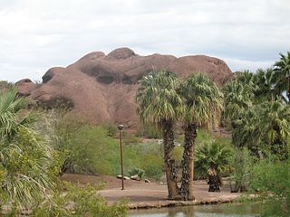
Papago Park is a municipal park of the cities of Phoenix and Tempe, Arizona, United States. It has been designated as a Phoenix Point of Pride. It includes Hunt's Tomb, which is listed on the National Register of Historic Places.

The Yavapai are a Native American tribe in Arizona. Historically, the Yavapai – literally “people of the sun” – were divided into four geographical bands who identified as separate, independent peoples: the Ɖo:lkabaya, or Western Yavapai; the Yavbe', or Northwestern Yavapai; the Guwevkabaya, or Southeastern Yavapai; and the Wi:pukba, or Northeastern Yavapai – Verde Valley Yavapai.

Presidio San Agustín del Tucsón was a presidio located within Tucson, Arizona, United States. The original fortress was built by Spanish soldiers during the 18th century and was the founding structure of what became the city of Tucson. After the American arrival in 1846, the original walls were dismantled, with the last section torn down in 1918. A reconstruction of the northeast corner of the fort was completed in 2007 following an archaeological excavation that located the fort's northeast tower.

The Yuma War was the name given to a series of United States military operations conducted in southern California and what is today southwestern Arizona from 1850 to 1853. The Quechan were the primary opponent of the United States Army, though engagements were fought between the Americans and other native groups in the region.

The Battle of Pima Butte, or the Battle of Maricopa Wells, was fought on September 1, 1857 at Pima Butte, Arizona near Maricopa Wells in the Sierra Estrella. Yuma, Mohave, Apache and Yavapai warriors attacked a Maricopa village named Secate in one of the largest battles in Arizona's history. It was also the last major battle fought by the Yumas and the last major battle fought solely between Native Americans in North America.

Charles A. Shibell was a teamster, miner, hotel owner, customs inspector, recorder, and Pima County, Arizona County Sheriff and a contemporary of Wyatt Earp and his brothers. Shibell promised a job as Deputy Sheriff to Earp, but when Earp announced his support for Bob Paul as the next sheriff, Shibell appointed Earp's antagonist Johnny Behan to the position instead.
The Yavapai Wars, or the Tonto Wars, were a series of armed conflicts between the Yavapai and Tonto tribes against the United States in the Arizona Territory. The period began no later than 1861, with the arrival of American settlers on Yavapai and Tonto land. At the time, the Yavapai were considered a band of the Western Apache people due to their close relationship with tribes such as the Tonto and Pinal. The war culminated with the Yavapai's removal from the Camp Verde Reservation to San Carlos on February 27, 1875, an event now known as Exodus Day.

The agricultural practices of the Native Americans inhabiting the American Southwest, which includes the states of Arizona and New Mexico plus portions of surrounding states and neighboring Mexico, are influenced by the low levels of precipitation in the region. Irrigation and several techniques of water harvesting and conservation were essential for successful agriculture. To take advantage of limited water, the southwestern Native Americans utilized irrigation canals, terraces (trincheras), rock mulches, and floodplain cultivation. Success in agriculture enabled some native Americans to live in communities which may have numbered as many as 40,000 people as compared to their former lives as hunter-gatherers in which their bands numbered only a few dozen.
Pima Villages, sometimes mistakenly called the Pimos Villages in the 19th century, were the Akimel O’odham (Pima) and Pee-Posh (Maricopa) villages in what is now the Gila River Indian Community in Pinal County, Arizona. First, recorded by Spanish explorers in the late 17th century as living on the south side of the Gila River, they were included in the Viceroyalty of New Spain, then in Provincias of Sonora, Ostimuri y Sinaloa or New Navarre to 1823. Then from 1824 to 1830, they were part of the Estado de Occidente of Mexico and from September 1830 they were part of the state of Sonora. These were the Pima villages encountered by American fur trappers, traders, soldiers and travelers along the middle Gila River from 1830s into the later 19th century. The Mexican Cession following the Mexican American War left them part of Mexico. The 1853 Gadsden Purchase made their lands part of the United States, Territory of New Mexico. During the American Civil War, they became part of the Territory of Arizona.
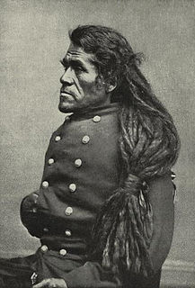
Irataba was a leader of the Mohave Nation, known as a mediator between the Mohave and the United States. He was born near the Colorado River in present-day Arizona. Irataba was a renowned orator and one of the first Mohave to speak English, a skill he used to develop relations with the United States.
Edward Franklin Castetter was an American ethnobotanist who studied the use of plants by Native American people in arid environments. He was a professor and served as the chair of the Department of Biology at the University of New Mexico. The biology building at UNM is named Castetter Hall in his honor.

Fort Tyson was a privately owned fort built in 1856 by Charles Tyson in the area which is now called Quartzsite, Arizona. He built the fort to protect the local miners and water supply from the raids of the Yavapai (Mohave-Apache), a Native-American tribe. The area in which Fort Tyson was located has been known as Fort Tyson, Tyson’s Well and is now called the town of Quartzsite because of the large amount of quartz found in its surrounding areas.

The indigenous peoples of the North American Southwest are those in the current states of Colorado, Arizona, New Mexico, Utah, and Nevada in the western United States, and the states of Sonora and Chihuahua in northern Mexico. An often quoted statement from Erik Reed (1964) defined the Greater Southwest culture area as extending north to south from Durango, Mexico to Durango, Colorado and east to west from Las Vegas, Nevada to Las Vegas, New Mexico. Other names sometimes used to define the region include "American Southwest", "Northern Mexico", "Chichimeca", and "Oasisamerica/Aridoamerica". This region has long been occupied by hunter-gatherers and agricultural people.
