
The Church of the Virgin Mary’s Immaculate Conception is a Roman Catholic church in Baku, Azerbaijan.

Strachów is a village in the administrative district of Gmina Kondratowice, within Strzelin County, Lower Silesian Voivodeship, in south-western Poland. Prior to 1945 it was in Germany. It lies approximately 6 kilometres (4 mi) south-west of Kondratowice, 15 km (9 mi) south-west of Strzelin, and 45 km (28 mi) south of the regional capital Wrocław.
Miedniki is a village in the administrative district of Gmina Uchanie, within Hrubieszów County, Lublin Voivodeship, in eastern Poland. It lies approximately 8 kilometres (5 mi) east of Uchanie, 13 km (8 mi) north-west of Hrubieszów, and 91 km (57 mi) south-east of the regional capital Lublin.
Kiersnówek is a village in the administrative district of Gmina Brańsk, within Bielsk County, Podlaskie Voivodeship, in north-eastern Poland. It lies approximately 4 kilometres (2 mi) south-east of Brańsk, 22 km (14 mi) west of Bielsk Podlaski, and 47 km (29 mi) south-west of the regional capital Białystok.
Podwysokie is a village in the administrative district of Gmina Skierbieszów, within Zamość County, Lublin Voivodeship, in eastern Poland. It lies approximately 6 kilometres (4 mi) north-east of Skierbieszów, 22 km (14 mi) north-east of Zamość, and 72 km (45 mi) south-east of the regional capital Lublin.
Wiatrowiec is a village in the administrative district of Gmina Pniewy, within Grójec County, Masovian Voivodeship, in east-central Poland. It lies approximately 6 kilometres (4 mi) south-west of Pniewy, 14 km (9 mi) west of Grójec, and 44 km (27 mi) south-west of Warsaw.
Kowalewo is a village in the administrative district of Gmina Drobin, within Płock County, Masovian Voivodeship, in east-central Poland. It lies approximately 8 kilometres (5 mi) west of Drobin, 24 km (15 mi) north-east of Płock, and 95 km (59 mi) north-west of Warsaw.
Borowo is a village in the administrative district of Gmina Rościszewo, within Sierpc County, Masovian Voivodeship, in east-central Poland. It lies approximately 4 kilometres (2 mi) north-west of Rościszewo, 6 km (4 mi) north-east of Sierpc, and 116 km (72 mi) north-west of Warsaw.
Gębiczyn is a village in the administrative district of Gmina Czarnków, within Czarnków-Trzcianka County, Greater Poland Voivodeship, in west-central Poland. It lies approximately 12 kilometres (7 mi) east of Czarnków and 56 km (35 mi) north of the regional capital Poznań.
Wtórek is a village in the administrative district of Gmina Ostrów Wielkopolski, within Ostrów Wielkopolski County, Greater Poland Voivodeship, in west-central Poland. It lies approximately 13 kilometres (8 mi) east of Ostrów Wielkopolski and 105 km (65 mi) south-east of the regional capital Poznań.
Koperno is a village in the administrative district of Gmina Gubin, within Krosno Odrzańskie County, Lubusz Voivodeship, in western Poland, close to the German border. It lies approximately 8 kilometres (5 mi) south of Gubin, 31 km (19 mi) south-west of Krosno Odrzańskie, and 54 km (34 mi) west of Zielona Góra.
Nowa Rola is a village in the administrative district of Gmina Tuplice, within Żary County, Lubusz Voivodeship, in western Poland. It lies approximately 7 kilometres (4 mi) north-east of Tuplice, 21 km (13 mi) north-west of Żary, and 49 km (30 mi) south-west of Zielona Góra.
Bełk is a village in the administrative district of Gmina Lidzbark, within Działdowo County, Warmian-Masurian Voivodeship, in northern Poland. It lies approximately 5 kilometres (3 mi) east of Lidzbark, 21 km (13 mi) west of Działdowo, and 72 km (45 mi) south-west of the regional capital Olsztyn.
Mycielin is a village in the administrative district of Gmina Dźwierzuty, within Szczytno County, Warmian-Masurian Voivodeship, in northern Poland. It lies approximately 5 kilometres (3 mi) north-west of Dźwierzuty, 21 km (13 mi) north of Szczytno, and 26 km (16 mi) east of the regional capital Olsztyn.

Yuancheng (Chinese: 源城; pinyin: Yuánchéng is the only district of the city of Heyuan, Guangdong Province, China.

Church of Michael the Archangel or Flotskaya is a Russian Orthodox church in central Baku, Azerbaijan, on Zargarpalan street. The church is dedicated to St. Michael. The church is serviced by Bishop Mefodi Efendiyev, three priests and one deacon.
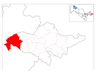
Paxtaobod District is a raion (district) of Andijan Region in Uzbekistan. The capital lies at Paxtaobod. The population is 147,500.

Shahrixon district is a tuman (district) of Andijan Region in Uzbekistan. The capital lies at Shahrixon.
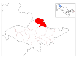
Ulugʻnor District is a raion (district) of Andijan Region in Uzbekistan. The capital lies at Oqoltin. The population is 47,300.
Ferwan is a Syrian village located in Sinjar Nahiyah in Maarrat al-Nu'man District, Idlib. According to the Syria Central Bureau of Statistics (CBS), Ferwan had a population of 395 in the 2004 census.


