The United Provinces of Agra and Oudh was a province of India under the British Raj, which existed from 22 March 1902 to 1937; the official name was shortened by the Government of India Act 1935 to United Provinces (UP), by which the province had been commonly known, and by which name it was also a province of independent India until 1950.

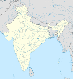
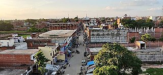
Ghazipur, is a city in the state of Uttar Pradesh, India. Ghazipur city is the administrative headquarters of the Ghazipur district, one of the four districts that form the Varanasi division of Uttar Pradesh. It is located on the Ganges (Ganga) River near the border with Bihar state, about 40 miles (65 km) northeast of Varanasi (Benares).The city of Ghazipur also constitutes one of the seven distinct tehsils, or subdivisions, of the Ghazipur district.

Shah Alam II, also known by his birth name Ali Gohar, or Ali Gauhar, was the seventeenth Mughal emperor and the son of Alamgir II. Shah Alam II became the emperor of a crumbling Mughal Empire. His power was so depleted during his reign that it led to a saying in the Persian language, Sultanat-e-Shah Alam, Az Dilli ta Palam, meaning, 'The empire of Shah Alam is from Delhi to Palam', Palam being a suburb of Delhi.

Varanasi division is one of the 18 administrative geographical units of the northern Indian state of Uttar Pradesh. Varanasi city is the administrative headquarters of the division. The division consists of 4 districts, i.e. Varanasi, Chandauli, Ghazipur, and Jaunpur and is loosely equivalent to the Benares State.

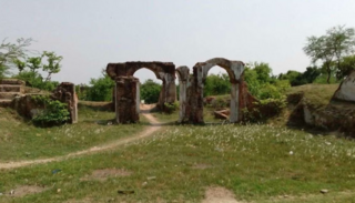
Ghazipur district is a district of Uttar Pradesh state in northern India. The city of Ghazipur is the district headquarters. The district is part of Varanasi Division. The region of Ghazipur is famous mainly for the production of its unique rose-scented Spray called Gulab Jal, and for the tomb of the Governor General of British India, Lord Cornwallis, who died here. His tomb is situated in Western part of City, and is conserved by Archaeological Survey of India.
Zamania is a town in the Indian state of Uttar Pradesh. Its municipal council is subordinate to the Ghazipur District. It is also the administrative head of Zamania tehsil,. It is also a very historical town, it derives its name from Ali Quli Khan Zaman, who was also known as Khan Zaman or Zaman Khan, he was a governor of Jaunpur, and Ghazipur during the time of Akbar.
Iraqi Biradri is a Sunni Muslim caste found chiefly in Ghazipur, Azamgarh, Ballia, Deoria and Gorakhpur districts of the eastern Uttar Pradesh in India. Iraqi Biradri is also referred to as Iraqi Shaikh.
Bahadurganj is a Municipality located in Zahurabad pargama of the Kasimabad Tehsil in Ghazipur district of Uttar Pradesh, India. Bahadurganj is located one the banks of Tamsa and Bhainsahi rivers.The town also served as the capital of Qasimabad estate.
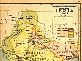
The Ceded and Conquered Provinces constituted a region in northern India that was ruled by the British East India Company from 1805 to 1834; it corresponded approximately—in present-day India—to all regions in Uttar Pradesh state with the exception of the Lucknow and Faizabad divisions of Awadh; in addition, it included the Delhi territory and, after 1816, the Kumaun division and a large part of the Garhwal division of present-day Uttarakhand state. In 1836, the region became the North-Western Provinces, and in 1904, the Agra Province within the United Provinces of Agra and Oudh.

Pariyar, also spelled Pariar, is a village in Sikandarpur Sarausi block of Unnao district, Uttar Pradesh, India. It is located on the left bank of the Ganges, 23 km northwest of the city of Unnao. Nearby the village is the Mahua lake. Pariyar holds religious significance to Hindus; it is considered to be the place where the goddess Sita was exiled to, and the birthplace of her two sons Lava and Kusha. The village is known for holding a major fair during the month of Kartika, on the day of the full moon, which is attended by over 100,000 people. Historically, Pariyar was the seat of a pargana since 1785, and under the Nawabs of Awadh it was the seat of a tehsildar. Today, it is the headquarters of a nyaya panchayat. Pariyar is connected by road with Mohan and Rasulabad. As of 2011, its population is 7,363, in 1,355 households.
Yusufpur and Mohammadabad is a Twin Town/Qasba in Mohammadabad Tahsil of the Ghazipur district of Uttar Pradesh, India.It belongs to Varanasi Division. Coordinates: 25°37′22″N 83°45′27″E It is located 21 km East of District headquarters Ghazipur and 347 km from the state capital, Lucknow. It borders the Ballia District, Mau District and Buxar District of Bihar. Yusufpur has a railway station which lies on the railway line linking Varanasi to Chhapra via Ghazipur and Ballia in the North Eastern Railway Zone. Yusufpur was founded by Qazi Ahmed Ansari in 1593.
Dildarnagar Kamsar is a pargana (region) and a mashra comprising 34 settlements located around the Karamnasa River in the Ghazipur district of Uttar Pradesh and the Kaimur district of Bihar, India. Of these, 18 mouzas are the primary settlements. It is a prominent settlement of Khanzadas, also known as Kamsari Pathans, as well as Afghan Pathans, primarily of the Niazi and Yusufzai clans. The original name of the region was Kamsar, but due to close and historical ties with the family of Bara Pathans, the region is often referred to as Kamsar-O-Bar. It was established in 1542 by Raja Narhar Khan.
Mahārāja Kam Dév Singh Urf Rao Dalpat Karam Singh (1438–1532) was a Sikarwar Bhumeehar, king of the Kanyakubja Gotra and belonged to Sikri dynasty, which ruled over the region of Fatehpur Sikri and then Fatuhabad near Fatehpur. He was ruler of the Pahargarh Estate, which mainly comprised what are now the cities of Morena, Gwalior, Jhansi, and Shivpuri, in old Rajputana region. Kam Dev was the son of Maharaja Jay Raj Dev Singh who was the ruler of the Vijaypur Sikri state. With this Kam Dev and Dham Dev were an ally of Rana Sanga.
Seorai is a village of Dildarnagar Kamsar, and also serve as the headquarters of SeoraiTahsil in region of Ghazipur District of Uttar Pradesh, India. The Seorai tehsil was made a tehsil of the Ghazipur District in year 2016. It consists of 142 villages and one town. Seorai main village has a total area of 878.02 hectares and a population of 20000 but its total area is 1,082.83 hectares and a population of 20,530 which also includes Bhadaura. Seorai tehsil has the total area of 366.62 km2 (141.55 sq mi). Seorai also served as the capital of Kamsaar estate from late 1500s to mid 1600s.
Nawali is a village in Seorai tehsil of Ghazipur District, Uttar Pradesh, India.
Qasimabad Estate, was a Zamindari estate and a jagir, named as Pargana, Zahurabad, located in the Ghazipur district of Uttar Pradesh, India it got the status of jagir in year 1675. The capital of Qasimabad estate was the town of Qasimabad but later, in 1758 the capital was shifted to Bahadurganj. It consisted of many places in the pargana of Zahurabad in 1901. The estate was established in year 1700 and it ended in 1956, completing a life span of 256 years.
Dewaitha is a village of Dildarnagar Kamsar,in Zamania tehsil of Ghazipur, India, located on the banks of the Karmanasa River and it's tributary Eknaiya, The village had a population of 7,104 as of the 2011 Census of India. The place is inhabited by Kamsar Pathans..

Inhauna is a village in the Singhpur block of Rae Bareli district, Uttar Pradesh, India. As of 2011, it has a population of 13,049 in 2,021 households.
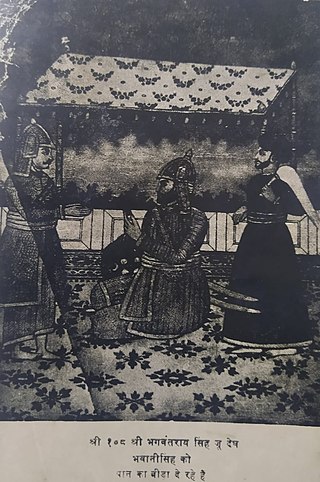
Raja Bhagwant Rai was an 18th-century Khichi Rajput ruler of Asothar and Ghazipur in the Fatehpur District of the Indian state of Uttar Pradesh. He is known for his resistance against the Mughal Empire and for establishing an independent state throughout his reign.
Maharaja Beni Bahadur was an administrator, minister, soldier and househelp in the courts of the Nawabs of Awadh from 1733 / 1734 to at least 1798 and at most 1814. He was most notable for his rapid rise to power, industry and charity.