
Healy is a census-designated place (CDP) in the borough seat of Denali Borough in the U.S. state of Alaska. The population was 1,021 at the 2010 census, up from 1,000 in 2000.

Bear Creek is a census-designated place (CDP) in Kenai Peninsula Borough, Alaska, United States. At the 2010 census the population was 1,956, up from 1,748 in 2000. Bear Creek is a few miles north of Seward near the stream of the same name and its source, Bear Lake.
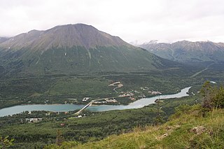
Cooper Landing is a census-designated place (CDP) in Kenai Peninsula Borough, Alaska, United States, about 100 miles (160 km) south of Anchorage, at the outlet of Kenai Lake into the Kenai River. The town was first settled in the 19th century by gold and mineral prospectors, and has become a popular summer tourist destination thanks to its scenic location and proximity to the salmon fishery of the Kenai River and Russian River. As of the 2010 census, the population in Cooper Landing was 289, down from 369 in 2000.

The willow ptarmigan is a bird in the grouse subfamily Tetraoninae of the pheasant family Phasianidae. It is also known as the willow grouse and in Ireland and Britain, where it was previously considered to be a separate species, as the red grouse. It is a sedentary species, breeding in birch and other forests and moorlands in northern Europe, the tundra of Scandinavia, Siberia, Alaska and northern Canada, in particular in the province of Newfoundland and Labrador. It is the state bird of Alaska. In the summer the birds are largely brown, with dappled plumage, but in the winter they are white with some black feathers in their tails. The species has remained little changed from the bird that roamed the tundra during the Pleistocene. Nesting takes place in the spring when clutches of four to ten eggs are laid in a scrape on the ground. The chicks are precocial and soon leave the nest and while they are young, both parents play a part in caring for them. The chicks eat insects and young plant growth while the adults are completely herbivorous, eating leaves, flowers, buds, seeds and berries during the summer and largely subsisting on the buds and twigs of willow and other dwarf shrubs and trees during the winter.
Turnagain Arm is a waterway into the northwestern part of the Gulf of Alaska. It is one of two narrow branches at the north end of Cook Inlet, the other being Knik Arm. Turnagain is subject to climate extremes and large tide ranges.

Birch Creek is a 150-mile (240 km) tributary of the Yukon River in the U.S. state of Alaska. Beginning at the confluence of Ptarmigan and Eagle creeks near Porcupine Dome, it flows southwest, then south under the Steese Highway and into the Steese National Conservation Area. It then turns east, then north, again passing under the Steese Highway and entering the Yukon Flats National Wildlife Refuge. Turning northwest, it ends where it splits into two distributaries, Lower Mouth Birch Creek and Upper Mouth Birch Creek, near Birch Creek, Alaska. The distributaries flow into the Yukon River at separate locations downstream of Fort Yukon.

Chugiak is an unincorporated community in the Municipality of Anchorage in the U.S. state of Alaska, situated approximately 20 miles (32 km) northeast of downtown Anchorage.

Chugach State Park covers 495,204 acres immediately east of the Anchorage Bowl in south-central Alaska. Though primarily in the Municipality of Anchorage, a small portion of the park north of the Eklutna Lake area in the vicinity of Pioneer Peak lies within the Matanuska-Susitna Borough. Established by legislation signed into law on August 6, 1970, by Alaska Governor Keith Miller, this state park was created to provide recreational opportunities, protect the scenic value of the Chugach Mountains and other geographic features, and ensure the safety of the water supply for Anchorage. The park, managed by Alaska State Parks, is the third-largest state park in the United States, and consists of geographically disparate areas each with different attractions and facilities. Only Anza-Borrego Desert State Park in California and Wood-Tikchik State Park in western Alaska are larger. Hunting and fishing are permitted in the Chugach under regulations established by the Alaska Department of Fish and Game for game management unit 14c. Target practice is not allowed within the park boundaries.

Lamplugh Glacier is an 8-mile-long (13 km) glacier located in Glacier Bay National Park and Preserve in the U.S. state of Alaska. It leads north to its 1961 terminus in Johns Hopkins Inlet, 1.4 miles (2.3 km) west of Ptarmigan Creek and 76 miles (122 km) northwest of Hoonah. The glacier was named by Lawrence Martin of the U.S. Geological Survey around 1912 for English geologist George William Lamplugh (1859–1926), who visited Glacier Bay in 1884.
Ptarmigan Creek Provincial Park and Protected Area is a provincial park in British Columbia, Canada.
Stony Creek is a 23.0-mile-long (37.0 km) tributary of the Susquehanna River in Dauphin County, Pennsylvania, in the United States.
Ptarmigan is the common name of birds of the genus Lagopus

Trail Creek also known as Trail River is a stream in the Chugach Mountains near Moose Pass, Alaska. It flows through the Trail Lakes and ends at Kenai Lake. There is a USFS campground near where the river empties into Kenai Lake, the river can be fished in the late summer for various species of trout.
Kern is a ghost town in the Municipality of Anchorage in the U.S. state of Alaska, located off of the Seward Highway. It was destroyed by a tsunami in 1964.

Resurrection Creek is a waterway in the Kenai Peninsula, Alaska, US. Along with Bear Creek, Sixmile Creek, and Glacier Creek, it is a tributary of Turnagain Arm. The stream's watershed drains 161 square miles (420 km2) on the north side of the Kenai Peninsula, and the community of Hope, Alaska is located at the creek's mouth. The Hope Highway passes alongside Resurrection Creek.
Palmer Creek is a waterway in the Kenai Peninsula, Alaska, US. It is an affluent of Resurrection Creek, itself a tributary of Turnagain Arm.
Troublesome Creek is a stream in Yukon–Koyukuk Census Area, Alaska, in the United States. It is a tributary of Hess Creek.
Ready Money Creek is a stream in Yukon–Koyukuk Census Area, Alaska, in the United States.
Nappy Creek is a stream in Nome Census Area, Alaska, in the United States.

Glacier Creek is a stream flowing out of the Chugach Mountains, which enters the Turnagain Arm of Cook Inlet near Girdwood, Alaska.

