Quebec Boundary Extension Act, 1898

Last updated
Quebec Boundary Extension Act, 1898
Act of Parliament
Evolution of the borders of the Province of Quebec Canada provinces evolution 2.gif
Evolution of the borders of the Province of Quebec

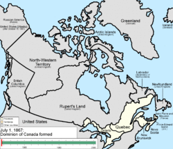
The Quebec Boundary Extension Act, 1898 was an Act of the Parliament of Canada that expanded the territory of the province of Quebec. [1] The province's northern boundary was set along the eastern shore of James Bay to the mouth of the Eastmain River, north along the river, then due east to the Hamilton River and down the river to the western boundary of Labrador. The area was part of the North-West Territories, formerly Rupert's Land, claimed by England in 1670.

The first of two such acts, a second act was passed by Parliament in 1912 and entitled the Quebec Boundaries Extension Act, 1912 . [2] Together, these two expansions more than tripled the size of the Province of Quebec to what it is today.

Related Research Articles

<span class="mw-page-title-main">Constitution of Canada</span> Principles, institutions and law of political governance in Canada

The Constitution of Canada is the supreme law in Canada. It outlines Canada's system of government and the civil and human rights of those who are citizens of Canada and non-citizens in Canada. Its contents are an amalgamation of various codified acts, treaties between the Crown and Indigenous Peoples, uncodified traditions and conventions. Canada is one of the oldest constitutional monarchies in the world.

<span class="mw-page-title-main">Quebec Act</span> 1774 law setting up Quebec as part of the British Empire

The Quebec Act, 1774 was an Act of the Parliament of Great Britain which set procedures of governance in the Province of Quebec. One of the principal components of the Act was the expansion of the province's territory to take over part of the Indian Reserve, including much of what is now southern Ontario, Illinois, Indiana, Michigan, Ohio, Wisconsin, and parts of Minnesota.

<span class="mw-page-title-main">Provinces and territories of Canada</span> Top-level subdivisions of Canada

Canada has ten provinces and three territories that are sub-national administrative divisions under the jurisdiction of the Canadian Constitution. In the 1867 Canadian Confederation, three provinces of British North America—New Brunswick, Nova Scotia, and the Province of Canada —united to form a federation, becoming a fully independent country over the next century. Over its history, Canada's international borders have changed several times as it has added territories and provinces, making it the world's second-largest country by area.

<span class="mw-page-title-main">Devolution</span> Granting of some competences of central government to local government

Devolution is the statutory delegation of powers from the central government of a sovereign state to govern at a subnational level, such as a regional or local level. It is a form of administrative decentralization. Devolved territories have the power to make legislation relevant to the area, thus granting them a higher level of autonomy.

<span class="mw-page-title-main">New Territories</span> Region of Hong Kong

The New Territories is one of the three main regions of Hong Kong, alongside Hong Kong Island and the Kowloon Peninsula. It makes up 86.2% of Hong Kong's territory, and contains around half of the population of Hong Kong. Historically, it is the region described in the Convention for the Extension of Hong Kong Territory. According to that treaty, the territories comprise the mainland area north of Boundary Street on the Kowloon Peninsula and south of the Sham Chun River, as well as over 200 outlying islands, including Lantau Island, Lamma Island, Cheung Chau, and Peng Chau in the territory of Hong Kong.

<span class="mw-page-title-main">Province of Quebec (1763–1791)</span> British colony of Quebec from 1763 to 1791

The Province of Quebec was a colony in British North America which comprised the former French colony of Canada. It was established by the Kingdom of Great Britain in 1763, following the conquest of New France by British forces during the Seven Years' War. As part of the Treaty of Paris, France gave up its claim to the colony; it instead negotiated to keep the small profitable island of Guadeloupe.

<span class="mw-page-title-main">Timeline of Quebec history (1867–1899)</span>

This section of the Timeline of Quebec history concerns the events relating to the province of Quebec, Canada between the enactment of the British North America Act of 1867 and the end of the 19th century.

<span class="mw-page-title-main">Timeline of Quebec history (1900–1930)</span>

This section of the Timeline of Quebec history concerns the events relating to the province of Quebec, Canada between the beginning of the 20th century and the Westminster statute.

<span class="mw-page-title-main">Electoral district (Canada)</span> Federal or provincial electoral district in Canada

An electoral district in Canada is a geographical constituency upon which Canada's representative democracy is based. It is officially known in Canadian French as a circonscription but frequently called a comté (county). In Canadian English it is also colloquially and more commonly known as a riding or constituency.

<i>Quebec Boundaries Extension Act, 1912</i>

The Quebec Boundaries Extension Act, 1912 was passed by the Parliament of Canada on April 1, 1912. It expanded the territory of the Province of Quebec, extending the northern boundary to its present location. The act transferred to the province all of the Northwest Territories' former District of Ungava except offshore islands. This is a vast area bounded by the Eastmain River, the Labrador coast, and Hudson and Ungava Bays. It was first claimed by England in 1670 as Rupert's Land by royal decree, becoming part of Canada after Confederation. The indigenous people of the region are Cree, Montagnais, Naskapi, and Inuit.

<span class="mw-page-title-main">District of Ungava</span>

The District of Ungava was a regional administrative district of Canada's Northwest Territories from 1895 to 1920, although it effectively ceased operation in 1912. It covered the northern portion of what is today Quebec, the interior of Labrador, and the offshore islands to the west and north of Quebec, which are now part of Nunavut.

Canadian Senate divisions refers to two aspects of the Senate of Canada. First, it refers to the division of Canada into four regional Senate divisions of 24 senators each, as set out in section 22 of the Constitution Act, 1867. The four regions are the Western Provinces, Ontario, Quebec and the Maritimes. These regions are intended to serve the Senate's purpose of providing regional representation in the Parliament of Canada, in contrast to the popular representation that the House of Commons is intended to provide. While not within any of the original four Senate divisions, Senate seats are also allocated to Newfoundland and Labrador and the three territories. The four divisions can be expanded when the need arises to have an extra two senators appointed to each regional division.

<span class="mw-page-title-main">Ahuntsic-Cartierville</span> Borough of Montreal in Quebec, Canada

Ahuntsic-Cartierville is a borough (arrondissement) of the city of Montreal, Quebec, Canada. The borough was created following the 2002 municipal reorganization of Montreal. It comprises two main neighbourhoods, Ahuntsic, a former village annexed to Montreal in 1910 and Cartierville, a town annexed to Montreal in 1916.

<span class="mw-page-title-main">Territorial evolution of Canada</span>

The history of post-confederation Canada began on July 1, 1867, when the British North American colonies of Canada, New Brunswick, and Nova Scotia were united to form a single Dominion within the British Empire. Upon Confederation, the United Province of Canada was immediately split into the provinces of Ontario and Quebec. The colonies of Prince Edward Island and British Columbia joined shortly after, and Canada acquired the vast expanse of the continent controlled by the Hudson's Bay Company, which was eventually divided into new territories and provinces. Canada evolved into a fully sovereign state by 1982.

Saint Maurice was an electoral district of the Legislative Assembly of the Parliament of the Province of Canada, in Canada East, on the north shore of the Saint Lawrence River, between Montreal and Quebec City. It was created for the first Parliament in 1841, and was based on the previous electoral district of the same name for the Legislative Assembly of Lower Canada. It was represented by one member in the Legislative Assembly.

<span class="mw-page-title-main">Territorial evolution of North America since 1763</span> Timeline of notable events

The 1763 Treaty of Paris ended the major war known by Americans as the French and Indian War and by Canadians as the Seven Years' War / Guerre de Sept Ans, or by French-Canadians, La Guerre de la Conquête. It was signed by Great Britain, France and Spain, with Portugal in agreement. Preferring to keep Guadeloupe, France gave up Canada and all of its claims to territory east of the Mississippi River to Britain. With France out of North America this dramatically changed the European political scene on the continent.

<span class="mw-page-title-main">Former colonies and territories in Canada</span> Former political entities in what is now Canada.

A number of states and polities formerly claimed colonies and territories in Canada prior to the evolution of the current provinces and territories under the federal system. North America prior to colonization was occupied by a variety of indigenous groups consisting of band societies typical of the sparsely populated North, to loose confederacies made up of numerous hunting bands from a variety of ethnic groups, to more structured confederacies of sedentary farming villages, to stratified hereditary structures centred on a fishing economy. The colonization of Canada by Europeans began in the 10th century, when Norsemen explored and, ultimately unsuccessfully, attempted to settle areas of the northeastern fringes of North America. Early permanent European settlements in what is now Canada included the late 16th and 17th century French colonies of Acadia and Canada, the English colonies of Newfoundland (island) and Rupert's Land, the Scottish colonies of Nova Scotia and Port Royal.

Ottawa County was an electoral district of the Legislative Assembly of the Parliament of the Province of Canada, in Canada East, in the Outaouais region across the Ottawa River from the city of Ottawa. It was created in 1841 and was based on the previous electoral district of the same name for the Legislative Assembly of Lower Canada. It was represented by one member in the Legislative Assembly.

<span class="mw-page-title-main">Newfoundland and Labrador–Quebec border</span> Border between two Canadian provinces

The border between the province of Quebec and the province of Newfoundland and Labrador is the longest interprovincial border in Canada. It stretches for more than 3,500 kilometres (2,200 mi) on land, and, according to both provincial governments, also contains a maritime part. Starting from the north, the border follows the Laurentian Divide on the Labrador Peninsula for the majority of the border's length, then follows the divide between the Côte-Nord-Gaspé and Newfoundland-Labrador drainage basins as far as Brûlé Lake, after which it goes along the Romaine River downstream to the 52nd parallel, which it follows east to its southeastern terminus at Blanc-Sablon.

<span class="mw-page-title-main">Ashuanipi</span>

The Territory of Ashuanipi was a formerly disputed area and territory of Quebec that was claimed by Quebec and the Dominion of Newfoundland from 1899 and 1927.

References

  1. Bur, Donald F. (2021-02-13). Laws of the Constitution: Consolidated. University of Alberta. p. 846. ISBN   978-1-77212-528-3.
  2. Desbiens, Caroline (2013-05-03). Power from the North: Territory, Identity, and the Culture of Hydroelectricity in Quebec. UBC Press. pp. 8–11. ISBN   978-0-7748-2419-4.