| Queguay Chico River | |
|---|---|
 | |
| Location | |
| Country | Uruguay |
The Queguay Chico River is a river of Uruguay.
| Queguay Chico River | |
|---|---|
 | |
| Location | |
| Country | Uruguay |
The Queguay Chico River is a river of Uruguay.

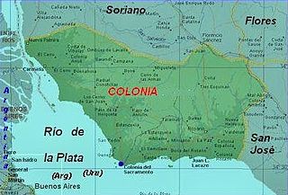
Colonia is a department of southwestern Uruguay. Its capital is Colonia del Sacramento, the country's second oldest city.

The Tagant Plateau is located in eastern Mauritania, forming a stony part of the Sahara Desert. The Tagant Region, a national administrative division, is named after the plateau.
Río Negro Department is a department of the northwestern region of Uruguay. It has an area of 9,282 km2 (3,584 sq mi) and a population of 54,765. Its capital is Fray Bentos. It borders Paysandú Department to the north, Tacuarembó Department to the east, Durazno Department to the southeast, Soriano Department to the south and has the Río Uruguay flowing at its west, separating it from Argentina.
Basketball at the 1948 Summer Olympics was the second appearance of the sport of basketball as an official Olympic medal event. A total number of 23 nations entered the competition.
Paysandú Department is a department of the northwestern region of Uruguay. It has an area of 13,922 km2 (5,375 sq mi) and a population of 113,124. Its capital is the city of Paysandú. It borders Salto Department to its north, Tacuarembó Department to its east, Río Negro Department to its south and has the Río Uruguay flowing at its west, separating it from Argentina.
Soriano is a department of Uruguay. Its capital is Mercedes. It is located on the west of the country, south of Río Negro Department, north of Colonia Department and west of Flores Department. Its western border is the Río Uruguay, separating it from Argentina.

The River Gade is a river running almost entirely through Hertfordshire. It rises from a spring in the chalk of the Chiltern Hills at Dagnall, Buckinghamshire and flows through Hemel Hempstead, Kings Langley, then along the west side of Watford through Cassiobury Park. After passing Croxley Green it reaches Rickmansworth, where it joins the River Colne. For its whole course the Gade is unnavigable.

Brazilian Island is a small uninhabited river island at the confluence of the Uruguay River and the Quaraí (Cuareim) River, between the borders of Argentina, Brazil and Uruguay, which is disputed by the two latter countries. The island is approximately 3.7 km (2.3 mi) long by 0.9 km (0.6 mi) wide, and it is located at 30°10′56″S57°37′43″W.

The Quaraí or Cuareim River is a tributary of the Uruguay River.

The Sefid-Rud is a river approximately 670 kilometres (416 mi) long, rising in the Alborz mountain range of northwestern Iran and flowing generally northeast to enter the Caspian Sea at Rasht. The river is Iran's second longest river after the Karun.
The Grande River (Uruguay) is a river in Uruguay.
Wedge Pass, also known as Billygoat Pass, 1430 m (4692 ft), is a mountain pass in the northern Garibaldi Ranges, the southwesternmost subdivisions of the Pacific Ranges of the Coast Mountains in British Columbia, Canada. Located immediately on the southern flank of Wedge Mountain and to the immediate north of the Spearhead Range, site of the Blackcomb half of the Whistler Blackcomb Ski Area, it connects the head of Wedge Creek (W), a tributary of the Green River with those of Billgoat Creek (E), a tributary of the Lillooet River. The pass is within Garibaldi Provincial Park and has no road access.

Ellen Wilkinson High School was housed, until it closed in 2000, in a Grade II* listed building in Ardwick, Manchester, England, designed in 1879–80 by the prolific Manchester architect Thomas Worthington. Formerly known as Nicholls Hospital, the building was funded by Benjamin Nicholls as a memorial to his son, John Ashton Nicholls. Nicholls commissioned Worthington to prepare designs in 1867, with instructions that building was only to commence after his own death. It was Worthington's last significant commission in the city. The original usage was as an orphanage; the Ashton family gave over £100,000 to its construction and endowment.

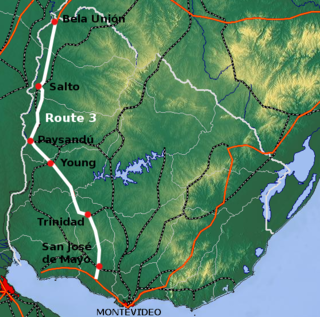
Route 3 is a national route of Uruguay. In 1975, it was assigned the name General José Artigas, the foremost national hero of Uruguay. It is one of the most important highways in the country along with Route 5, connecting the south coast near Rafael Perazza with Bella Unión in the extreme northwest. The road is approximately 592 kilometres (368 mi) in length.

This is a list of the extreme points of Uruguay, the points that are farther north, south, east or west than any other location, and the highest and lowest points. It is also notable that Uruguay's northernmost point is farther south than the northernmost point of any other nation.

Gartental is a Mennonite agricultural settlement in Río Negro Department, Uruguay. It is located 360 km (220 mi) NW of Montevideo, near San Javier, not far from Route 24.
Polk Township is an inactive township in Ray County, in the U.S. state of Missouri. It is part of the Kansas City metropolitan area.

The Brazil–Uruguay border is a strip of land located south of the southern Brazilian state of Rio Grande do Sul. It stretches for 985 km from the triple border Brazil-Argentina-Uruguay west to the mouth of Arroyo Chuí, the southernmost point in Brazil.
Coordinates: 32°09′12″S57°28′09″W / 32.1533°S 57.4692°W